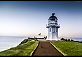
Location | Otiki Hill, East Cape North Island New Zealand |
---|---|
Coordinates | 37°41′20.2″S178°32′53.3″E / 37.688944°S 178.548139°E Coordinates: 37°41′20.2″S178°32′53.3″E / 37.688944°S 178.548139°E |
Tower | |
Constructed | 1900 |
Construction | cast iron tower |
Automated | 1985 |
Height | 15 metres (49 ft) |
Shape | cylindrical tower with balcony and lantern |
Markings | white tower, black lantern roof |
Power source | mains electricity |
Operator | Maritime New Zealand [1] |
Light | |
First lit | 1900 |
Focal height | 154 metres (505 ft) |
Range | 35 kilometres (22 mi) |
Characteristic | Fl W 10s. |
East Cape Lighthouse is a lighthouse sited on Otiki Hill [2] above East Cape, the easternmost point on the North Island of New Zealand. [3] [4] It is owned and operated by Maritime New Zealand. The lighthouse was originally constructed on nearby East Island. However the island was difficult to access (four men died during tower construction when their boat capsized) [4] and proved to be susceptible to earthquakes and subsequent landslips. In 1920 a decision was made to relocate the light to the mainland and in April 1922, the light was extinguished and then relit at its current location in December of that year. Originally manned by three lighthouse keepers, the light's staffing was progressively reduced until it was fully automated in 1985. [4] It is now controlled from the Maritime New Zealand headquarters in Wellington. While the area around the light is accessible by foot, the lighthouse itself is not open to the public.
East Cape is the easternmost point of the main islands of New Zealand. It is located at the northern end of the Gisborne District of New Zealand's North Island. It can also refer to the broader Gisborne cape.
Cape Reinga Lighthouse is a lighthouse at Cape Reinga in the Northland Region of the North Island of New Zealand. It is owned and operated by Maritime New Zealand. The lighthouse is a common New Zealand icon and a popular tourist destination although the lighthouse itself is not open to the public.
Cuvier Island Lighthouse is a lighthouse on Cuvier Island, a small island off the east coast of the North Island of New Zealand. It is owned and operated by Maritime New Zealand.
Cape Egmont Lighthouse is a lighthouse at Cape Egmont in the Taranaki Region of the North Island of New Zealand. It is owned and operated by Maritime New Zealand. The light was manufactured by Simpson & Co., Pimlico, London, in 1864 and erected on Mana Island to the north west of Porirua in 1865, but it was sometimes confused with the Pencarrow Head light at the entrance to Wellington Harbour and in 1877 the light was dismantled and moved to Cape Egmont.
Cape Palliser Lighthouse is a lighthouse at Cape Palliser in the Wellington region of the North Island of New Zealand. It is owned and operated by Maritime New Zealand.
Castle Point Lighthouse, located near the village of Castlepoint in the Wellington Region of the North Island of New Zealand, is the North Island's tallest lighthouse standing 52 metres above sea level and is one of only two left in New Zealand with a rotating beam. It is owned and operated by Maritime New Zealand.
Nugget Point Lighthouse is a lighthouse at Nugget Point in the Otago region of the South Island of New Zealand. It is owned and operated by Maritime New Zealand.
Mokohinau Islands Lighthouse is a lighthouse on Burgess Island, one of the Mokohinau Islands, which lie off the northeast coast of the North Island of New Zealand. It is owned and operated by Maritime New Zealand. The lighthouse sits at the entrance to the Hauraki Gulf as the landfall light for vessels approaching Auckland from the north and northeast.
Cape Campbell Lighthouse is a lighthouse at Cape Campbell in the Marlborough region of the South Island of New Zealand. It is owned and operated by Maritime New Zealand. The original lighthouse at this site was first lit on 1 August 1870. However, this lighthouse was constructed of timber, and in 1898 these timbers were found to be decaying. This led to the construction of the current cast iron tower, which began operating in October 1905.
Waipapa Point Lighthouse is a lighthouse located at Waipapa Point, Southland, New Zealand. It was first lit on 1 January 1884.
Cape Baily Light is an active lighthouse located at Cape Baily, a headland at the south side of the entrance to Botany Bay, New South Wales, Australia. The light serves to help north-bound shipping hug the coast to avoid the strong southerly currents further out to sea.
Cape Fourcroy Light is an active lighthouse located on Cape Fourcroy, on the southwestern tip of Bathurst Island, Northern Territory, Australia. The lighthouse marks the beginning of the route from the Timor Sea to Darwin.
Cape Hotham Light is an active lighthouse in the Northern Territory of Australia located on Cape Hotham on the coastline of the Van Diemen Gulf about 80 kilometres (50 mi) northeast of the territory capital of Darwin, The lighthouse marks the entrance to Clarence Strait, the eastern approach to Darwin.
Archer Point Light is an active lighthouse on Archer Point, a conical, 60-metre-high (200 ft) grassy headland about 14 kilometres (8.7 mi) southeast of Cooktown, Queensland, Australia. Originally an 1883 timber frame lighthouse covered with galvanised iron, it was replaced in 1975 with a modern square concrete equipment room topped with a lantern.
The New Burnett Heads Light, also known as South Head Light, is an active lighthouse standing on the south side of the Burnett River entrance, in Burnett Heads, Queensland, Australia. In 1971 it replaced the Old Burnett Heads Light, which was relocated inland.
Point Danger Light, also known as the Captain Cook Memorial Light, is an active lighthouse located on Point Danger, a headland between Coolangatta and Tweed Heads, marking the border between Queensland and New South Wales, Australia. It lays claim to be the first lighthouse in the world to experiment with laser as a light source.
Cape Bowling Green Light is an active lighthouse located on Cape Bowling Green, a lengthy headland ending with a long low sandspit, about 30 kilometres (19 mi) from Ayr, Queensland, Australia. The lighthouse is at the end of the headland, near the base of the sandspit. The first lighthouse at the location, established in 1874, was moved multiple times. It was prefabricated in Brisbane, shipped to the location, moved twice due to coastal erosion and finally transferred for display at the Australian National Maritime Museum at Darling Harbour in Sydney.
Cape Cleveland Light is an active heritage-listed lighthouse located on the northern tip of Cape Cleveland, a promontory projecting into the Coral Sea west of Cleveland Bay in the locality of Cape Cleveland about 40 kilometres (25 mi) east of Townsville, Queensland, Australia. The lighthouse marks the northern point of the Cape, and the entrance to Cleveland Bay.
The Tuhawaiki Point Lighthouse or Jack's Point Lighthouse stands near to Timaru at the east coast of the South Island of New Zealand.
Wikimedia Commons has media related to East Cape Lighthouse . |