Related Research Articles
Ruatoria is a town in the Waiapu Valley of the Gisborne Region in the northeastern corner of New Zealand's North Island. The town was originally known as Cross Roads then Manutahi and was later named Ruatorea in 1913, after the Māori Master female grower Tōrea who had some of the finest storage pits in her Iwi at the time (Te-Rua-a-Tōrea). In 1925 the name was altered to "Ruatoria", although some texts retain the original spelling.

Te Araroa is a town in the Gisborne Region of the North Island of New Zealand. It is situated 175 km north of Gisborne city, along State Highway 35 between Tokata and Awatere. Te Araroa is the birthplace of noted Māori politician Sir Āpirana Ngata. Māori in the area are generally associated with the Ngāti Porou iwi. It is 100 metres from its local beach.

Te Aitanga-a-Māhaki is one of the three principal Māori iwi of the Tūranga district; the others being Rongowhakaata and Ngai Tamanuhiri. It is numerically the largest of the three, with 6,258 affiliated members as of 2013.
Raukokore is a small settlement close to the East Cape in the northeastern North Island of New Zealand. It is located on State Highway 35, close to the mouth of the Raukokore River, 40 kilometres to the west of Hicks Bay.
Te Karaka is a small settlement inland from Gisborne, in the northeast of New Zealand's North Island. It is located in the valley of the Waipaoa River close to its junction with its tributary, the Waihora River. Te Karaka is located on State Highway 2, and is the largest settlement between Gisborne and Ōpōtiki in the Bay of Plenty.
Pātūtahi is a small settlement 15 kilometres from Gisborne, in the northeast of New Zealand's North Island. It is located in the valley of the Waipaoa River. From 1915 to 1931 Pātūtahi had a railway station on the Ngātapa Branch.
Mātāwai is a small inland settlement in the Gisborne Region in the northeast of New Zealand's North Island. It is located on the upper reaches of the Motu River, in the Raukumara Range. It is on State Highway 2 between Gisborne and Ōpōtiki.
Makaraka is an outer suburb of Gisborne, in New Zealand's North Island, located in the west of the city. The suburb features Gisborne's horse-racing circuit, Makaraka Racecourse. It is part of the statistical area of Makaraka-Awapuni, which is covered at Awapuni.
Manutūkē is a settlement in the Gisborne District of New Zealand's North Island. It is located to the west of the city of Gisborne on State Highway 2, close to the mouth of the Waipaoa River.
Whatatutu is a small settlement in the northeast of New Zealand's North Island. It is located north of Te Karaka on the upper reaches of the Waipaoa River, close to its meeting with its tributaries, the Mangatu River and Waingaromia River.

Kaiwhaiki is a settlement 18 kilometres (11 mi) upriver from Whanganui, New Zealand.
Putere is a village and rural community in the Wairoa District of the Hawke's Bay Region, on New Zealand's North Island. It is located around the small Lake Rotoroa and Lake Rotonuiaha. The main road to Putere runs from Raupunga on State Highway 2.
Muriwai is a settlement and rural community at the southern end of Poverty Bay, in the Gisborne District of New Zealand's North Island, south of Manutuke. The main settlement is just west of Young Nick's Head. State Highway 2 runs through Muriwai on its way from Gisborne to Hawke's Bay.
Horoera is a village and rural community in Gisborne District of New Zealand's North Island. It is located east of Te Araroa and north of East Cape, at Horoera Point.
Potaka is a village and rural community in Gisborne District of New Zealand's North Island. It marks the northern and western end of the Gisborne District and the Ngāti Porou tribal territory.
Whareponga is a bay and rural community in the Gisborne District of New Zealand's North Island. It is located north of Waipiro Bay, and is the mouth of Whareponga Stream and Wharekaka Stream.
Ngātapa is a rural community in the Gisborne District of New Zealand's North Island.
Wharerātā or Bartletts is a rural coastal community in the Gisborne District of New Zealand's North Island. It is located on State Highway 2 between Wairoa and Gisborne.
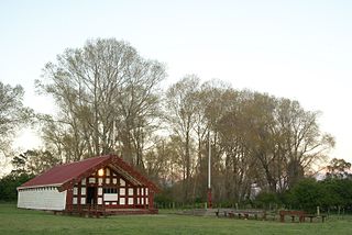
Makarika is a rural community and valley in the Gisborne District of New Zealand's North Island. It is located just south of Ruatoria and Hiruharama, off State Highway 35. The Penu Pā includes a memorial to Private Parekura Makarini McLean, who was killed in combat in Egypt in 1941, during World War II.
References
- ↑ "Kapa haka, a way of life". Gisborne Herald. 1 September 2017.
- ↑ "Te Kāhui Māngai directory". tkm.govt.nz. Te Puni Kōkiri.
- ↑ "Māori Maps". maorimaps.com. Te Potiki National Trust.
- ↑ Peters, Mark (25 September 2020). "Short film based on well-told family story". Gisborne Herald.
- ↑ "Marae Announcements" (Excel). growregions.govt.nz. Provincial Growth Fund. 9 October 2020.
- ↑ "Gisborne Parks and Reserves". gdc.govt.nz. Gisborne District Council.