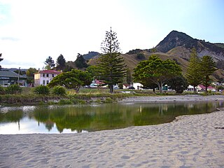
Tokomaru Bay is a small beachside community located on the isolated East Coast of New Zealand's North Island. It is 91 km north of Gisborne, on State Highway 35, and close to Mount Hikurangi. The district was originally known as Toka-a-Namu, which refers to the abundance of sandflies. Over the years the name was altered to Tokomaru Bay.

East Cape is the easternmost point of the main islands of New Zealand. It is located at the northern end of the Gisborne District of New Zealand's North Island. It can also refer to the broader Gisborne cape.

Māhia Peninsula is located on the east coast of New Zealand's North Island, in the Hawke's Bay region, between the towns of Wairoa and Gisborne.

Tolaga Bay is both a bay and small town on the East Coast of New Zealand's North Island located 45 kilometres northeast of Gisborne and 30 kilometres south of Tokomaru Bay.
Tiniroto is a small farming and forestry community on the “inland” road from Gisborne to Wairoa in the eastern part of the North Island of New Zealand.

Wharekahika or Hicks Bay is a bay and coastal area in the Gisborne District of the North Island of New Zealand. It is situated 150 km east of Opotiki and 186 km north of Gisborne city, along State Highway 35 between Potaka and Te Araroa.
Rawhiti is a small beachfront town about 27km from Russell in the Bay of Islands of New Zealand.

Gisborne District or the Gisborne Region is a local government area of northeastern New Zealand. It is governed by Gisborne District Council, a unitary authority. It is named after its largest settlement, the city of Gisborne. The region is also commonly referred to as the East Coast.
Awapuni is a suburb of the New Zealand city of Gisborne, located in the southwest of the city. It is named after the Awapuni lagoon, where the Waipaoa River runs into the ocean. The New Zealand Ministry for Culture and Heritage gives a translation of "blocked-up river" for Awapuni.

Whataupoko is the central suburb of the New Zealand city of Gisborne. It is located to the northeast of the city business district.
Te Karaka is a small settlement inland from Gisborne, in the northeast of New Zealand's North Island. It is located in the valley of the Waipaoa River close to its junction with its tributary, the Waihora River. Te Karaka is located on State Highway 2, and is the largest settlement between Gisborne and Opotiki in the Bay of Plenty.
Manutūkē is a settlement in the Gisborne District of New Zealand's North Island. It is located to the west of the city of Gisborne on State Highway 2, close to the mouth of the Waipaoa River.

Wainui Beach is a small settlement on the coast of New Zealand's North Island, located just to the north of Tuaheni Point, some 8 km to the east of Gisborne, to which it is linked by State Highway 35.

Pataua is a settlement in Northland Region, New Zealand. It lies at the mouth of the Pataua River on the Pacific Ocean. Pataua North and Pataua South are separated by a footbridge over the estuary.
Waitahanui is a village in the Taupō District, Waikato region, New Zealand. The village is on the eastern shore of Lake Taupō, 14 km (9 mi) south of the district seat of Taupō.
Hexton is a village and rural area in the Gisborne District of New Zealand's North Island. It is located north-west of Gisborne City, and includes the settlements of Makauri and Waerengaahika.
Riverdale is a suburb of Gisborne, in the Gisborne District of New Zealand's North Island.
Elgin is a suburb of Gisborne, in the Gisborne District of New Zealand's North Island. It is located east and north of Awapuni, south of Te Hapara and west of Gisborne Central.

Gisborne Central is the central business district and central suburb of Gisborne, in the Gisborne District of New Zealand's North Island. It is located east of Elgin, south of Whataupoko and west of Kaiti.
Whakaki is a settlement east of Wairoa within the Wairoa District and Hawke's Bay Region of New Zealand's North Island. State Highway 2 runs through it.


