Related Research Articles

Gisborne is a city in northeastern New Zealand and the largest settlement in the Gisborne District. It has a population of 38,200. Gisborne District Council has its headquarters in the central city.

Young Nick's Head / Te Kurī is a headland at the southern end of Tūranganui-a-Kiwa / Poverty Bay in New Zealand's North Island. The area is the landing place of the Horouta and Te Ikaroa-a-Rauru waka which carried Māori settlers to the region around 1350 AD. In Māori, the promontory is named Te Kuri o Pāoa.
The Ruahine Range is the largest of several mountain ranges in the North Island of New Zealand that form a ridge running parallel with the east coast of the island between East Cape and Wellington. The ridge is at its most pronounced from the central North Island down to Wellington, where it comprises the Ruahine, Tararua and Remutaka Ranges.

Mount Hikurangi is a 1,752 m (5,748 ft) peak in the eastern corner of New Zealand's North Island, about 80 kilometres (50 mi) north of Gisborne, and 50 kilometres (31 mi) southwest of the East Cape Lighthouse. On a spur of the Raukumara Range in the Waiapu Valley, it is the North Island's highest non-volcanic peak.
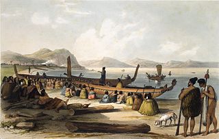
Waka are Māori watercraft, usually canoes ranging in size from small, unornamented canoes used for fishing and river travel to large, decorated war canoes up to 40 metres (130 ft) long.

Tainui was one of the great ocean-going canoes in which Polynesians migrated to New Zealand approximately 800 years ago. It was commanded by the chief Hoturoa, who had decided to leave Hawaiki because over-population had led to famine and warfare. The ship first reached New Zealand at Whangaparāoa in the Bay of Plenty and then skirted around the north coast of the North Island, finally landing at Kawhia in the western Waikato. The crew of the Tainui were the ancestors of the iwi that form the Tainui confederation.

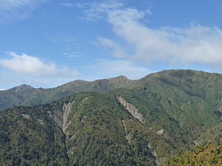
The Raukūmara Range runs from the north-eastern end of the Huiarau Range north-eastward to Wharekahika / Hicks Bay, between Cape Runaway and East Cape, at the northern end of the Gisborne District, on the North Island of New Zealand. It is the north-northeastern end segment of the North Island's main mountain chain, which runs from Wellington in the south to the Gisborne District. The western side of the range is in the Ōpōtiki District of the eastern Bay of Plenty and the eastern side in the East Coast region of the Gisborne District. State Highway 2 runs between the Raukūmara Range and the Huiarau Range on its route between the town of Ōpōtiki and the city of Gisborne.

Mount Taupiri is a hill at the southern end of the Taupiri Range in the Waikato. The highest peak in the range, it rises to 288 metres above sea level and overlooks Taupiri township immediately to its south. It is separated from the Hakarimata Range to the south by the Taupiri Gorge, through which the Waikato River flows from the Waikato Basin to the Lower Waikato. The Mangawara Stream joins the Waikato River at the base of the hill.

Te Aitanga-a-Hauiti is a Māori iwi (tribe) on the East Coast of New Zealand's North Island. Its rohe covers the area from Tawhiti-a-Paoa Tokomaru Bay to Te Toka-a-Taiau Gisborne on the East Coast of the North Island of New Zealand.
Ngāriki Kaipūtahi, Ngāriki Kaiputahi or Te Iwi o Ngāriki Kaipūtahi is a Māori iwi (tribe) in the Mangatu area of Gisborne District, New Zealand. Its present-day members are all descended from Rawiri Tamanui.
Mount Arowhana is a 1440-metre (4724 ft) mountain that is part of the backbone of the Raukumara Range in the northeast of New Zealand's North Island. The range forms part of a line of mountains extending along the eastern side of the North Island between the Gisborne District and Wellington.

Mount Raukūmara is a 1413-metre (4636 ft) mountain that is the northernmost major peak in the Raukūmara Range in the northeast of New Zealand's North Island. It is part of the backbone of the range, which forms part of a line of mountains extending along the eastern side of the North Island between the Gisborne District and Wellington.
Mātāwai is a small inland settlement in the Gisborne Region in the northeast of New Zealand's North Island. It is located on the upper reaches of the Motu River, in the Raukumara Range. It is on State Highway 2 between Gisborne and Ōpōtiki.
The Huiarau Range is a range of mountains in Te Urewera in the northeast of New Zealand's North Island. Part of the spine of mountains that run roughly parallel with the island's east coast, it is a southwestern extension of the Raukumara Range, lying between the end of that range and the North Island Volcanic Plateau. Peaks within the range include Mount Manuoha, Maungataniwha, and Maungapohatu. Lake Waikaremoana lies close to the southern edge of the range.
Waituhi is a small settlement in the Gisborne District of New Zealand's North Island. It is 21 km (13 mi) northwest of the city of Gisborne, on the western bank of the Waipaoa River. It is notable as the historic site of Popoia pā, and as the setting for several novels and short stories of Witi Ihimaera. Members of the Te Whanau-a-Kai Te Aitanga-a-Māhaki iwi (tribe) are the tangata whenua. In 2009 a project to develop a community drinking water supply was started.
The Raukumara Region of New Zealand corresponds to the East Cape of the North Island, and associated mountain ranges.

Waiapu Valley, also known as the Waiapu catchment, Waiapu River valley or simply Waiapu, is a valley in the north of the Gisborne Region on the East Coast of the North Island of New Zealand. It is the catchment area for the Waiapu River and its tributaries, and covers 1,734 square kilometres (670 sq mi). The Raukumara Range forms the western side of the valley, with Mount Hikurangi in the central west. The towns of Ruatoria and Tikitiki are in the north-east of the valley.

The Takitimu Mountains extend in a north–south direction southeast of Te Anau and Manapouri. The mountain range is about 30 kilometres (19 mi) long and contains several peaks of around 1,600 metres (5,200 ft) height, with the Brunel Peaks reaching 1,650 metres (5,410 ft).

Ōpōtiki District is a territorial authority district in the eastern Bay of Plenty Region on the North Island of New Zealand. It stretches from Kutarere and the eastern shore of Ōhiwa Harbour in the west to Cape Runaway in the north-east, and south from Ōpōtiki town up the Waioeka River into the Raukumara Range. Ōpōtiki District Council is headquartered in Ōpōtiki, the largest town.
The Kakaramea-Tihia Massif is an andesitic volcano in the central North Island of New Zealand. It extends from the peak of Kakaramea at 1,300 metres (4,300 ft) in the west to the peak of Tinui at 1,169 metres (3,835 ft). The term Kakaramea means many colours in Māori and relates to rock/soil colour on parts of the massif so is a common place name in New Zealand. The massif is located in the North Island Volcanic Plateau, to the south of Lake Taupō. Lake Rotoaira lies to the south-east as does further away Mount Tongariro and to the east is Pihanga on the other side of the Te Ponanga Saddle from Tihia.
References
- 1 2 "Our History". mahaki.com. Retrieved 3 November 2016.
| | This Gisborne District-related geography article is a stub. You can help Wikipedia by expanding it. |