
Dungeness is a headland on the coast of Kent, England, formed largely of a shingle beach in the form of a cuspate foreland. It shelters a large area of low-lying land, Romney Marsh. Dungeness spans Dungeness Nuclear Power Station, the hamlet of Dungeness, and an ecological site at the same location. It lies within the civil parish of Lydd.

Te-Oneroa-a-Tōhē / Ninety Mile Beach is on the western coast of the far north of the North Island of New Zealand. The beach is actually 88 kilometres long. Its southern end is close to the headland of Tauroa Point, to the west of Ahipara Bay, near Kaitaia. From there it sweeps briefly northeast before running northwest along the Aupouri Peninsula for the majority of its length. It ends at Tiriparepa / Scott Point, 5 kilometres (3 mi) south of Cape Maria van Diemen and about 10 kilometres (6 mi) south of Cape Reinga / Te Rerenga Wairua.

Cape Kidnappers, known in Māori as Te Kauwae-a-Māui and officially gazetted as Cape Kidnappers / Te Kauwae-a-Māui, is a headland at the southeastern extremity of Hawke's Bay on the east coast of New Zealand's North Island and sits at the end of an 8 kilometres (5.0 mi) peninsula which protrudes into the Pacific Ocean. It is 20 kilometres (12 mi) south-east of the city of Napier. Access to the Cape by road stops at Clifton, which is the departure point for many tourists. The Cape Kidnappers Golf Course lies between the headland and the nearby coastal community of Te Awanga.

North Cape is the northernmost point of New Zealand's main islands. At the northeastern tip of the Aupouri Peninsula, the cape lies 30 kilometres (19 mi) east and three kilometres (1.9 mi) north of Cape Reinga. The name North Cape is sometimes used to refer just to the cape that is known in Māori as Otou and which overlooks Murimotu Island, and sometimes just to the eastern point of Murimotu Island. It is also used to refer to the whole larger headland stretching about five kilometres from Murimotu Island westwards to Kerr Point and including the Surville Cliffs. Statistics New Zealand uses a statistical area called North Cape for population data, extending south down the Aupouri Peninsula to the Houhora Heads.

Bream Head is a promontory on the east coast of Northland in the North Island of New Zealand. Located at the end of a 30 kilometre-long peninsula, the head juts into the Pacific Ocean to the southeast of Whangārei. The Te Whara Track in the Bream Head Scenic Reserve is at least 700 years old. The Hen and Chicken Islands are located off the headland at a distance of 12 kilometres. It forms the northern extremity of Bream Bay, and guards the entrance to Whangārei Harbour, a natural inlet extending to the northwest. The Marsden Point Oil Refinery is located on the opposing shore of the harbour five kilometres to the west.
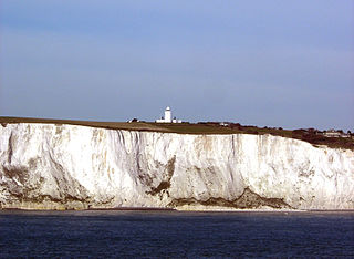
South Foreland is a chalk headland on the Kent coast of southeast England. It presents a bold cliff to the sea, and commands views over the Strait of Dover. It is centred 3 miles (4.8 km) northeast of Dover and 15 miles south of North Foreland. It includes the closest point on the Island of Britain to the European mainland at a distance of 20.6 miles (33.2 km).

Lawyers Head is a prominent landmark on the coast of Otago, New Zealand. Located within the city of Dunedin, this rocky headland juts into the Pacific Ocean at the eastern end of the city's main beach, Saint Kilda Beach. It is named for the likeness of the cliff face to the profile of a lawyer in traditional legal wig.
Pakiri is a locality in Auckland, in the former Rodney District of New Zealand. Leigh is about 9 kilometres (6 mi) to the south-east. The Pakiri River flows through the area and into the Hauraki Gulf to the north-east.

Cuspate forelands, also known as cuspate barriers or nesses in Britain, are geographical features found on coastlines and lakeshores that are created primarily by longshore drift. Formed by accretion and progradation of sand and shingle, they extend outwards from the shoreline in a triangular shape.

Foreland Point is a rocky headland in Devon near Lynmouth, and is the most northerly point along the Devon and Exmoor coast. The highest cliff is 89 metres (292 ft) above the high tide, although the highest point of the entire headland is near Countisbury at 302 metres (991 ft). The headland is owned by the National Trust; some areas are open to public access all year, as part of the South West Coast Path, while other areas have limited access. The Trinity House-operated Lynmouth Foreland Lighthouse is also located here.
Shag Point / Matakaea is a headland and township in East Otago, New Zealand.
Whangara is a small community in the northeast of New Zealand's North Island, located between Gisborne and Tolaga Bay, five kilometres southwest of Gable End Foreland and two kilometres east of State Highway 35.
The Cascade River is a river of the South Island of New Zealand. It flows north for 30 kilometres (19 mi) from its source in Mount Aspiring National Park in the Southern Alps, forming a deep valley between the Olivine Range and Red Hills Range. From the end of this valley it turns west to cross a low-lying swampy floodplain before entering the Tasman Sea close to Cascade Point, a headland halfway between Big Bay and Jackson Bay.

False Round Point is a point 16 km (9.9 mi) west of North Foreland and 4 km (2.5 mi) south of Ridley Island, on the north coast of King George Island in the South Shetland Islands of Antarctica. The point has appeared on charts since about 1822. It was probably named for its similarity to Round Point, which lies 22 km (14 mi) to the west, by Discovery Investigations personnel on the Discovery II who charted the north coast of this island in 1937.
Skarvsnes Foreland is an extensive foreland surmounted by bare rock peaks and indented by several coves, protruding into the east part of Lutzow-Holm Bay, Antarctica. It was first mapped by Norwegian cartographers from air photos taken by the Lars Christensen Expedition (LCE) of 1936–37. Its name means "barren mountain headland." Most other features on the foreland were mapped and named by LCE personnel, with a few others mapped from surveys and air photos by Japanese Antarctic Research Expedition (JARE) of 1957–62. Unless otherwise specified, the following features were mapped and named by LCE personnel.

North Foreland is an ice-free headland on the northern coast of King George Island, the largest of the South Shetland Islands of Antarctica. It lies at the eastern entrance to Emerald Cove, 4.5 km east of Milosz Point, extending northwards for about 2 km and forming the northernmost extremity of the Island.

Cape Banks is a headland in the Australian state of South Australia located in the gazetted locality of Carpenter Rocks at the south end of Bucks Bay and the north end of Bungaloo Bay on the state's south east coast about 36 kilometres west south west of the city of Mount Gambier.
Cape Northumberland is a headland in the southeast of the Australian state of South Australia. It is the southernmost point of South Australia. It is located about 3 kilometres (1.9 mi) from the town of Port MacDonnell, 28 kilometres south southwest from the municipal seat of Mount Gambier and about 393 kilometres (244 mi) southeast of the state's capital Adelaide.

Sculpture on the Gulf is a temporary outdoor art exhibition on a coastal headland on Matiatia Bay, Waiheke Island, New Zealand. It is a biennial event founded in 2003 by the Waiheke Community Art Gallery.
