Related Research Articles

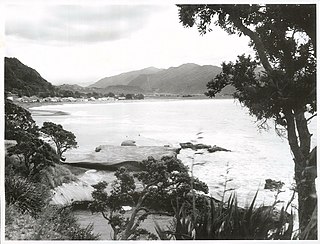
Tokomaru Bay is a small beachside community located on the isolated East Coast of New Zealand's North Island. It is 91 km north of Gisborne, on State Highway 35, and close to Mount Hikurangi. The district was originally known as Toka-a-Namu, which refers to the abundance of sandflies. Over the years the name was altered to Tokomaru Bay.

Ruatahuna is a town in the northeast of New Zealand's North Island, 90 kilometres west of Gisborne, and 18 kilometres northwest of Lake Waikaremoana. It is situated on the unsealed part of SH38, from Wai-O-Tapu via Murupara to Wairoa.

Te Kaha is a small New Zealand community situated in the Bay of Plenty near Ōpōtiki.
Nuhaka is a small settlement in the northern Hawke's Bay Region of New Zealand's eastern North Island, lying on State Highway 2 between Wairoa and Gisborne.
Frasertown is a small settlement in the northern Hawke's Bay Region of New Zealand's eastern North Island.
Te Araroa is a town in the Gisborne Region of the North Island of New Zealand. It is situated 175 km north of Gisborne city, along State Highway 35 between Tokata and Awatere. Te Araroa is the birthplace of noted Māori politician Sir Āpirana Ngata. Māori in the area are generally associated with the Ngāti Porou iwi. It is 100 metres from its local beach.

Te Aitanga-a-Mahaki is one of the three principal Māori iwi of the Tūranga district; the others being Rongowhakaata and Ngai Tamanuhiri. It is numerically the largest of the three, with 6,258 affiliated members as of 2013.
Rangitukia is a small settlement 10 kilometres south of East Cape in the northeast of New Zealand's North Island. It is located close to the mouth of the Waiapu River.
Kaiti is a suburb of the New Zealand city of Gisborne. It is located immediately to the east of the city centre, on the opposing bank of the Waimata River. Kaiti Hill or Titirangi overlooks Poverty Bay with Young Nick's Head across the Bay. Titirangi also overlooks the city. The Turanganui River is below it, and separates Kaiti from the Gisborne Central Business District.

Te Karaka is a small settlement inland from Gisborne, in the northeast of New Zealand's North Island. It is located in the valley of the Waipaoa River close to its junction with its tributary, the Waihora River. Te Karaka is located on State Highway 2, and is the largest settlement between Gisborne and Opotiki in the Bay of Plenty.
Matawai is a small inland settlement in the Gisborne Region in the northeast of New Zealand's North Island. It is located on the upper reaches of the Motu River, in the Raukumara Range. It is on State Highway 2 between Gisborne and Opotiki.
Manutuke is a settlement in the Gisborne District of New Zealand's North Island. It is located to the west of the city of Gisborne on State Highway 2, close to the mouth of the Waipaoa River.
Ruatoki or 'Rūātoki is a locality in the Bay of Plenty Region of New Zealand. It is located at the base of the Urewera Valley, approximately 20 km south of Whakatāne.
Muriwai is a settlement and rural community at the southern end of Poverty Bay, in the Gisborne District of New Zealand's North Island. It is located south of Manutake State Highway 2.
Potaka is a village and rural community in Gisborne District of New Zealand's North Island. It marks the northern and western end of the Gisborne District and the Ngāti Porou tribal territory.
Ngatapa is a rural community in the Gisborne District of New Zealand's North Island.
Hexton is a village and rural area in the Gisborne District of New Zealand's North Island. It is located north-west of Gisborne City, and includes the settlements of Makauri and Waerengaahika.
Makarika is a rural community and valley in the Gisborne District of New Zealand's North Island. It is located just south of Ruatoria and Hiruharama, off State Highway 35. The Penu Pā includes a memorial to Private Parekura Makarini McLean, who was killed in combat in Egypt in 1941, during World War II.
Tuai is a village and rural community located around Lake Whakamarino, in the Wairoa District of the Hawke's Bay Region, on New Zealand's North Island.
Omaio is a coastal township in the Ōpōtiki District and Bay of Plenty Region of New Zealand's North Island.
References
- ↑ Hariss, Gavin. "Patutahi, Gisborne". topomap.co.nz. NZ Topo Map.
- ↑ "Te Kāhui Māngai directory". tkm.govt.nz. Te Puni Kōkiri.
- ↑ "Māori Maps". maorimaps.com. Te Potiki National Trust.
- ↑ "Marae Announcements" (Excel). growregions.govt.nz. Provincial Growth Fund. 9 October 2020.
- ↑ "Education Review Office Report". ero.govt.nz. Education Review Office.
- ↑ "Ministry of Education School Profile". educationcounts.govt.nz. Ministry of Education.
Coordinates: 38°37′S177°54′E / 38.617°S 177.900°E
| This Gisborne District-related geography article is a stub. You can help Wikipedia by expanding it. |