
The Tasman Sea is a marginal sea of the South Pacific Ocean, situated between Australia and New Zealand. It measures about 2,000 km (1,200 mi) across and about 2,800 km (1,700 mi) from north to south. The sea was named after the Dutch explorer Abel Janszoon Tasman, who was the first recorded European to encounter New Zealand and Tasmania. British explorer Lieutenant James Cook later extensively navigated the Tasman Sea in the 1770s as part of his first voyage of exploration.

Viti Levu is the largest island in the Republic of Fiji, the site of the nation's capital, Suva, and home to a large majority of Fiji's population.
The Ruahine Range is the largest of several mountain ranges in the North Island of New Zealand that form a ridge running parallel with the east coast of the island between East Cape and Wellington. The ridge is at its most pronounced from the central North Island down to Wellington, where it comprises the Ruahine, Tararua and Remutaka Ranges.

Mount Hikurangi is a 1,752 m (5,748 ft) peak in the eastern corner of New Zealand's North Island, about 80 kilometres (50 mi) north of Gisborne, and 50 kilometres (31 mi) southwest of the East Cape Lighthouse. On a spur of the Raukumara Range in the Waiapu Valley, it is the North Island's highest non-volcanic peak.

The Torlesse Composite Terrane is a plate tectonic terrane forming part of the South Island of New Zealand. It contains the Rakaia, Aspiring and Pahau Terranes and the Esk Head Belt. Greywacke is the dominant rock type of the composite terrane; argillite is less common and there are minor basalt occurrences. The Torlesse Composite Terrane is found east of the Alpine Fault in the Southern Alps of New Zealand. Its southern extent is a cryptic boundary with the Caples Terrane within the Haast Schists in Central Otago. It is named for the Torlesse Range in Canterbury.

The Haast Schist which contains both the Alpine and Otago Schist is a metamorphic unit in the South Island of New Zealand. It extends from Central Otago, along the eastern side of the Alpine Fault to Cook Strait. There are also isolated outcrops of the Haast Schist within the central North Island. The schists were named after Haast Pass on the West Coast. The Haast Schist can be divided geographically from north to south into the Kaimanawa, Terawhiti, Marlborough, Alpine, Otago and Chatham schist.

The volcanism of New Zealand has been responsible for many of the country's geographical features, especially in the North Island and the country's outlying islands.

The Gisborne District is an area of northeastern New Zealand governed by the Gisborne District Council. A unitary authority, it is also known as the Gisborne Region. It is named after its largest settlement, the city of Gisborne. The region is also commonly referred to as the East Coast.

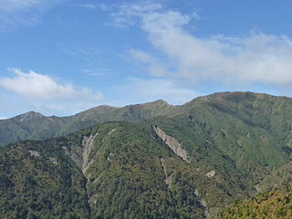
Mount Raukumara is the northernmost major peak in the Raukumara Range in the northeast of New Zealand's North Island. Part of the backbone of the range, which forms part of a line of mountains extending across much of the North Island, 1343 metre (4404 ft) Raukumara is the third-highest peak in the range. It is clearly visible from a great distance at sea, being located only 25 kilometres from both Cape Runaway and East Cape.

The geology of New Zealand is noted for its volcanic activity, earthquakes and geothermal areas because of its position on the boundary of the Australian Plate and Pacific Plates. New Zealand is part of Zealandia, a microcontinent nearly half the size of Australia that broke away from the Gondwanan supercontinent about 83 million years ago. New Zealand's early separation from other landmasses and subsequent evolution have created a unique fossil record and modern ecology.
The Poroporo River is a river of the Gisborne Region of New Zealand's North Island. It flows east from its sources in the eastern foothills of the Raukumara Range, reaching the Waiapu River close to its mouth, having shared the Waiapu's bed since the town of Tikitiki.
The Raukumara Region of New Zealand corresponds to the East Cape of the North Island, and associated mountain ranges.

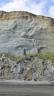
The Tahora Formation is a Late Cretaceous geologic formation that outcrops in northeastern New Zealand near Gisborne. It is Haumurian in age according to the New Zealand geologic time scale. It forms part of the Upper Cretaceous to Teurian (Danian) Tinui Group. It unconformably overlies the Jurassic to Lower Cretaceous Urewera Group or the Upper Cretaceous Matawai Group. It is conformably overlain by the Haumurian to Teurian Whangai Formation. It consist of three members, the Maungataniwha Sandstone Member, the Mutuera Member and the Houpapa Member. It is named for Tahora Station, south of Matawai in the Gisborne Region. The aptly named Maungataniwha Sandstone Member is known for its rich reptile fossil remains, first investigated by amateur palaeontologist Joan Wiffen.

The Wairau Fault is an active dextral strike-slip fault in the northeastern part of South Island, New Zealand. It forms part of the Marlborough Fault System, which accommodates the transfer of displacement along the oblique convergent boundary between the Indo-Australian Plate and Pacific Plate, from the transform Alpine Fault to the Hikurangi Trench subduction zone.

Waiapu Valley, also known as the Waiapu catchment, Waiapu River valley or simply Waiapu, is a valley in the north of the Gisborne Region on the East Coast of the North Island of New Zealand. It is the catchment area for the Waiapu River and its tributaries, and covers 1,734 square kilometres (670 sq mi). The Raukumara Range forms the western side of the valley, with Mount Hikurangi in the central west. The towns of Ruatoria and Tikitiki are in the north-east of the valley.
The 1934 Pahiatua earthquake struck at 11:46 pm on 5 March, causing severe damage in much of the lower North Island. Wairarapa, Wellington and Hawke's Bay felt the strongest levels of shaking, with much of New Zealand feeling the tremor.

This is a list of the units into which the rock succession of New Zealand is formally divided. As new geological relationships have been discovered new names have been proposed and others are made obsolete. Not all these changes have been universally adopted. This table is based on the 2014 New Zealand Stratigraphic Lexicon (Litho2014). However, obsolete names that are still in use and names postdating the lexicon are included if it aids in understanding.

The geology of the West Coast of New Zealand's South Island is divided in two by the Alpine Fault, which runs through the Region in a North-East direction. To the West of the fault Paleozoic basement rocks are interluded by plutones and both are unconformably covered in a sedimentary sequence. To the East of the Alpine Fault are the Mesozoic Alpine Schist and Greywacke of the Southern Alps. There are numerous active faults throughout the region.

The Southland Syncline is a major geological structure located in the Southland Region of New Zealand's South Island. The syncline folds the Mesozoic greywackes of the Murihiku Terrane. The northern limb of the fold is steep to overturned, while the southern limb dips shallowly to the northeast. The axial plan dips to the northeast and the axis plunges to the southeast.
The Wanganui Basin is an onshore-offshore basin on the North Island of New Zealand. The basin provides an important stratigraphic and palaeontological record for the late Neogene marine environment of New Zealand.
