Dog Island Lighthouse

Last updated

Dog Island Lighthouse
Dog Island Lighthouse 03 crop.jpg
The Dog Island Lighthouse in 2011 with its distinctive stripes
Dog Island Lighthouse
Location Dog Island, Foveaux Strait, New Zealand
Coordinates 46°39′07″S168°24′38″E / 46.65190°S 168.4105°E / -46.65190; 168.4105
Tower
Constructed1865
Constructionstone tower
Automated1989
Height36 metres (118 ft)
Shapecylindrical tower with balcony and lantern
Markingswhite tower with two black bands, black lantern dome
Power sourcesolar power  OOjs UI icon edit-ltr-progressive.svg
OperatorMaritime New Zealand [1]
HeritageHeritage New Zealand Category 1 historic place listing  OOjs UI icon edit-ltr-progressive.svg
Light
Focal height46 metres (151 ft)
Range19 nautical miles (35 km; 22 mi)
Characteristic FI W 10s.
Designated22 November 1984
Reference no. 395

The Dog Island Lighthouse on Dog Island in Foveaux Strait is New Zealand's tallest lighthouse, and one of its oldest. It is notable for its masonry construction, and is a work example by an engineer who was prominent at the time. The lighthouse employed the first revolving beam in New Zealand, and the unique original light apparatus was in use for 60 years. Dog Island Lighthouse is one of the most distinct lighthouses in New Zealand, with only two others having stripes painted on them for better visibility at daytime. The lighthouse is registered by Heritage New Zealand as a Category I structure, and the adjacent lighthouse keepers cottage has a Category II registration. Originally operated by three lighthouse keepers, the structure has since 1989 been remote controlled from Maritime New Zealand's Wellington office, with Dog Island since having been uninhabited. Dog Island Lighthouse has twice featured on New Zealand stamps.

Contents

Background

It was clear that a lighthouse was needed in Foveaux Strait, but there were long discussions in the 1860s where to place it. Captains with local experience were asked for their opinion, and they suggested possible sites on Centre Island, Ruapuke Island, Stewart Island, Solander Islands, and Dog Island. [2] The latter was chosen as Southland's first site for a lighthouse; the recommendation was made by the Invercargill Harbour Master to James Alexander Robertson Menzies, the first Superintendent of the Southland Province. [3] The Harbour Master's rationale was that the island was dangerous, as "it is very low and not seen till close upon it". [2] At the time, the Southland Province had just split from Otago Province, and both provincial governments were involved. There was confusion over who would take ownership of the situation, and in the end, the central government assumed responsibility for the construction of all lighthouses throughout the colony. [4]

Construction

James Balfour, at the time marine engineer to the Otago Provincial Council and later to the Colonial Government of New Zealand, [5] was commissioned during 1863 to design the lighthouse. [4] Balfour ordered the lighthouse equipment and the light apparatus from the renowned Edinburgh lighthouse designer Alan Stevenson. [6] Balfour had trained under Stevenson's brothers David and Thomas Stevenson. In 1848, Balfour's older sister Maggie had married Thomas Stevenson, hence the Stevensons were his brothers-in-law. [7] [8]

The equipment arrived on the ship City Of Dunedin from Glasgow in Port Chalmers on 3 September 1863, and the light apparatus arrived via the ship Resolute on 17 March 1864. The light apparatus for the Taiaroa Head lighthouse also arrived on the Resolute. [9]

Dog Island is low-lying and rocky, and its highest (natural) point is about 15 metres (49 ft) above sea level. [2] Calculations showed that the lighthouse would have to be some 110 feet (34 m) tall if built on the highest point to be effective. An investigation showed that there was enough rock that could be quarried on the island for the structure, and that it would be too expensive to build such a tall tower from steel. [10]

The tower designed by Balfour was 36 metres (118 ft) tall. It had a diameter of 6.6 metres (22 ft) at its base, and 5.0 metres (16.4 ft) below the balcony. The lantern was placed at a height of 30.5 metres (100 ft). Two dwellings, also designed by Balfour, were constructed for the lighthouse keepers and their families. [11] The total cost came to £10,480-12s-8d, which was significantly more than the average cost of between £4,000 and £6,000 at the time. [12] The light apparatus was specifically designed for the remoteness of the location. Instead of the usual central burner system with one lamp, sixteen lamps were used arranged in four, each with their own mirror behind it. The lamps were mounted on a frame with a square base that completed a revolution powered by a massive clockwork every two minutes, thus achieving a beam every 30 seconds. The reason behind the arrangement was redundancy; even if one of the lamps failed, the other three pointing in the same direction would still produce a, albeit somewhat weaker, beam. The light mechanism was also reasonably simple to repair should the need arise. [12] It was the first revolving light apparatus in New Zealand. [9]

History

Dog Island Lighthouse in the early 1900s Dog Island Lighthouse, early 1900s.jpg
Dog Island Lighthouse in the early 1900s
Dog Island Lighthouse keeper's wife and baby in 1924 Dog Island Lighthouse Keeper's wife and baby.jpg
Dog Island Lighthouse keeper's wife and baby in 1924

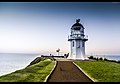
The lighthouse was first operated on 5 August 1865. Within a year of its construction, it was noted that the tower oscillated in high winds much more than other towers. [13] Due to weak peaty subsoils, the tower took on a slight lean. [14] During storms, the tower leaked severely and it was feared that this would strengthen the mortar between the stones. Weak mortar was scraped out in 1867 and replaced with Portland cement. At the same time, the tower was painted with a large white stripe in the middle, with the remainder painted in black, both to make the tower more visible during daylight, but also to further waterproof the structure. This colour scheme has remained ever since. [13]

In 1871, a crack appeared at the base of the tower and the Marine Engineer of the day ordered immediate strengthening. This was carried out with strong hardwood and wrought iron bands. This work, significantly hindered by bad weather, cost £978-4s-3d. [15] By 1916, it was decided that major strengthening was necessary again, as the cement grout was failing. Plans drawn up then and amended two years later saw a reinforced concrete skin of 2 feet (0.61 m) in thickness being applied to the outside up to just below the balcony, and an internal 6 inches (150 mm) reinforced concrete lining up to the fourth floor. The tower was repainted in its previous colour scheme. [16]

The burners for the lights were changed from colza oil to paraffin oil in 1876. The original system was in use for 60 years, and in 1925, the optical apparatus was upgraded to a second order dioptric lens with an incandescent oil burner. This changed the light output to three flashes in quick succession every 30 seconds. A diesel electric plant was installed in 1954, and electrical operation of the beam started in October of that year. The diesel generator was replaced in 1970. [16] In September 1999, the light was replaced again, this time with a rotating beacon, with a 35-watt halogen bulb as the light source. The energy comes from solar panels and a battery bank. [14]

A third dwelling for lighthouse keepers was built in 1884. [17] The three original dwellings were in a poor state by the 1920s and two houses with six rooms each were built for the families; at the same time, the two original cottages became storage sheds. A new house was built in 1979 for the by then single lighthouse keeper. [18]

There were originally three lighthouse keepers with their families on the island. [14] The initial rotating light mechanism had to be wound up hourly, and in 1883, the principal lighthouse keeper died when he fell down the central shaft trying to attach weights to the mechanism. [14] In 1977, the number of lighthouse keepers were reduced from two to one due to operational improvements. There was a Committee of Inquiry into lighthouse automation in 1981 and the Dog Island site was one of nine sites throughout New Zealand that was to remain staffed; in this case, it was due to its remoteness, and its ability to help with search and rescue in the area. In August 1989, Dog Island was fully automated and the last permanent lighthouse keeper in New Zealand was withdrawn from service. [18] The lighthouse is remote controlled from Maritime New Zealand's Wellington office. [14]

Despite the lighthouse, the steamer SS Waikouaiti ran aground on Dog Island on 28 November 1939 during dense fog and was wrecked. [19]

Stamps

Dog Island Lighthouse has twice featured on New Zealand stamps. In 1969, the New Zealand Government Life Insurance Department (better known as Government Life) issued five stamps showing lighthouses, [nb 1] with the highest denomination (15c) depicting the Dog Island Lighthouse. [20] In 2009, New Zealand Post issued five stamps commemorating the 150th anniversary of New Zealand's oldest lighthouse at Pencarrow Head; the Dog Island Lighthouse was included with a $1 value. [21]

Today

Dog Island Lighthouse 02.jpg

The lighthouse was automated in 1989, and the island has since been uninhabited. [14] The lighthouse is the tallest lighthouse in New Zealand, and one of its oldest. [22] Due to its black and white stripes, it might be one of New Zealand's most distinctive lighthouses. [22] There are only two other lighthouses in New Zealand of similar appearance; Cape Campbell Lighthouse also has black and white stripes, whilst Cape Palliser Lighthouse has red and white stripes. [14] The lens from 1925 is on display at the Museum of Wellington City & Sea on Jervois Quay in Wellington, on loan from Maritime New Zealand. [9] [23] The 1865 rotating mechanism can be seen at the Bluff Maritime Museum. [9]

There is no public access to Dog Island or to the lighthouse. [22] The lighthouse is being maintained by Maritime New Zealand. [22]

Heritage registrations

The lighthouse keepers cottage was registered by the New Zealand Historic Places Trust (now Heritage New Zealand) on 24 November 1983 as a Category II structure, with registration number 2562. [24] On 22 November 1984, the Dog Island Lighthouse was registered as a Category I structure, with registration number 395. The lighthouse is significant for its height, its age, and the relatively rare use of masonry for such a structure. It is also an example of the work of an engineer who was prominent at his time. [25]

See also

Footnotes

  1. Government Life was established in 1869 and since an unprecedented decision in 1890 could issue its own stamps for its correspondence. Government Life has always used lighthouses on its stamps, but mostly stylised. The organisation is now called Tower Insurance. [20]

Citations

  1. Rowlett, Russ. "Lighthouses of New Zealand: South Island". The Lighthouse Directory. University of North Carolina at Chapel Hill . Retrieved 23 February 2016.
  2. 1 2 3 Bain 2010, p. 7.
  3. Bain 2010, pp. 7f.
  4. 1 2 Bain 2010, p. 8.
  5. Grace's Guide: Balfour.
  6. Bain 2010, pp. 8f.
  7. "The Late Mr Balfour". The Star . No. 503. 29 December 1869. p. 3. Retrieved 4 January 2015.
  8. Beaglehole, Helen (9 July 2013). "Lighthouses - A national system". Te Ara: The Encyclopedia of New Zealand . Retrieved 4 January 2015.
  9. 1 2 3 4 Phillips, Mark (29 December 2009). "New Zealand Lighthouses". newzealandlighthouses.com. Archived from the original on 16 December 2014. Retrieved 4 January 2015.
  10. Bain 2010, p. 9.
  11. Bain 2010, pp. 9, 13.
  12. 1 2 Bain 2010, p. 10.
  13. 1 2 Bain 2010, p. 11.
  14. 1 2 3 4 5 6 7 "Dog Island Lighthouse". Maritime New Zealand. Archived from the original on 22 January 2019. Retrieved 30 March 2019.
  15. Bain 2010, p. 12.
  16. 1 2 Bain 2010, p. 13.
  17. Bain 2010, pp. 13f.
  18. 1 2 Bain 2010, p. 14.
  19. "Waikouaiti (1939)". Tripod. Retrieved 13 July 2012.
  20. 1 2 "Government Life". New Zealand Post . Retrieved 4 January 2015.
  21. "Lighthouses of New Zealand". New Zealand Post. Archived from the original on 4 January 2015. Retrieved 4 January 2015.
  22. 1 2 3 4 "Lighthouses of Foveaux Strait - a history". Department of Conservation . Retrieved 4 January 2015.
  23. Beaglehole, Helen (9 July 2013). "Lighthouses - Lights: from oil to electricity". Te Ara: The Encyclopedia of New Zealand . Retrieved 4 January 2015.
  24. "Dog Island Lighthouse Keepers Cottage (Former)". New Zealand Heritage List/Rārangi Kōrero. Heritage New Zealand . Retrieved 4 January 2015.
  25. "Dog Island Lighthouse". New Zealand Heritage List/Rārangi Kōrero. Heritage New Zealand . Retrieved 4 January 2015.

Related Research Articles

<span class="mw-page-title-main">Lighthouse</span> Structure designed to emit light to aid navigation

A lighthouse is a tower, building, or other type of physical structure designed to emit light from a system of lamps and lenses and to serve as a beacon for navigational aid, for maritime pilots at sea or on inland waterways.

<span class="mw-page-title-main">The Brothers (New Zealand)</span>

The Brothers is a group of small islands in Cook Strait, New Zealand, off the east coast of Cape Koamaru, Arapaoa Island. The islands are a restricted-access wildlife sanctuary administered by the Department of Conservation.

<span class="mw-page-title-main">Cape Palliser Lighthouse</span> Lighthouse in New Zealand

Cape Palliser Lighthouse is a lighthouse at Cape Palliser in the Wellington region of the North Island of New Zealand. It is owned and operated by Maritime New Zealand.

<span class="mw-page-title-main">Nugget Point Lighthouse</span> Lighthouse in New Zealand

Nugget Point Lighthouse is a lighthouse at Nugget Point in the Otago region of the South Island of New Zealand. It is owned and operated by Maritime New Zealand.

<span class="mw-page-title-main">Fingal Head Light</span> Lighthouse in New South Wales, Australia

Fingal Head Light is an active lighthouse located at Fingal Head, New South Wales, Australia, a headland about 5 kilometres (3.1 mi) south of Point Danger, which marks the Queensland border.

<span class="mw-page-title-main">Kiama Light</span> Lighthouse in New South Wales, Australia

Kiama Light, also known as Kiama Harbour Light, is an active lighthouse in Kiama, New South Wales, Australia. The lighthouse is located close to the Kiama Blowhole on Blowhole Point, south of Kiama Harbour.

<span class="mw-page-title-main">Point Stephens Light</span> Lighthouse in New South Wales, Australia

The Point Stephens Light is a heritage-listed active lighthouse located on Point Stephens, a point on an unnamed headland at the east of Fingal Bay, 4.25 km (2.64 mi) south of the entrance of Port Stephens, New South Wales, Australia. The light serves to assist vessels entering Port Stephens. It is considered an endangered lighthouse due to remote location and old age.

<span class="mw-page-title-main">Warden Head Light</span> Lighthouse in New South Wales, Australia

Warden Head Light, also known as Ulladulla Lighthouse, is an active lighthouse on Warden Head, a headland south of Ulladulla, New South Wales, Australia, guarding the entrance to the Port of Ulladulla. It is one of only two wrought iron lighthouses in New South Wales, the other being its sibling, Wollongong Breakwater Lighthouse. It is also notable for two relocations: the tower was constructed in 1873 on the Ulladulla Breakwater, and relocated in 1889 to its current location. Its keeper's house was relocated to a different location in the 1920s.

<span class="mw-page-title-main">Cape Don Light</span> Lighthouse in Northern Territory, Australia

Cape Don Light is an active lighthouse located on Cape Don, at the tip of the Cobourg Peninsula, Northern Territory, Australia, in Garig Gunak Barlu National Park, marking the entrance to the Dundas Strait. It is Australia's northernmost traditional lighthouse. The station served on the important route to Darwin, between the peninsula and Melville Island. The tower was constructed in 1915–1917, during the "Golden Age of Australian Lighthouses" (1913–1920), and the tower was manned until 1983. During the entire period that the tower was manned it also maintained meteorological records which were well placed to assist in cyclone development tracking. The complex consists of the lighthouse, three residences and ancillary buildings.

<span class="mw-page-title-main">Cape Capricorn Light</span> Lighthouse in Queensland, Australia

Cape Capricorn Light is an active heritage-listed lighthouse located on Cape Capricorn, a coastal headland on the northeast point of Curtis Island, in Gladstone Region, Central Queensland, Australia. The lighthouse, constructed in 1964, is the third at this site, following a timber frame lighthouse constructed in 1875 and a concrete lighthouse constructed around 1937. It was added to the Queensland Heritage Register on 31 August 2001.

<span class="mw-page-title-main">Cape Bowling Green Light</span> Lighthouse in Queensland, Australia

Cape Bowling Green Light is an active lighthouse on Cape Bowling Green, a long headland ending in a long low sandspit, about 30 kilometres (19 mi) from Ayr, Queensland, Australia. The lighthouse is at the end of the headland, near the base of the sandspit. The first lighthouse at the location, established in 1874, was moved multiple times. It was prefabricated in Brisbane, shipped to the location, moved twice due to coastal erosion and finally transferred for display at the Australian National Maritime Museum at Darling Harbour in Sydney.

<span class="mw-page-title-main">Cape Moreton Light</span> Lighthouse in Queensland, Australia

Cape Moreton Light, also listed as North Point Range Rear Light, is a heritage-listed active lighthouse located on Cape Moreton, a rocky headland located at the north eastern tip of Moreton Island, a large sand island on the eastern side of Moreton Bay, on the coast of South East Queensland, Australia. It marks the northern entrance to Moreton Bay and Brisbane and also serves as the rear light for the North Point Range. With its two distinctive red bands, it also serves as a daymark. It is the oldest lighthouse in Queensland, and the only one to be built by the New South Wales Government before the separation of Queensland, which took place in 1859. It is also the only lighthouse in Queensland to be built of stone.

<span class="mw-page-title-main">Cape Cleveland Light</span> Lighthouse in Queensland, Australia

Cape Cleveland Light is an active heritage-listed lighthouse located on the northern tip of Cape Cleveland, a promontory projecting into the Coral Sea west of Cleveland Bay in the locality of Cape Cleveland about 40 kilometres (25 mi) east of Townsville, Queensland, Australia. The lighthouse marks the northern point of the Cape, and the entrance to Cleveland Bay.

<span class="mw-page-title-main">Double Island Point Light</span> Lighthouse

Double Island Point Light is an active lighthouse located at the summit of Double Island Point, a coastal headland within the Cooloola section of the Great Sandy National Park. It is located at the southern end of Wide Bay, 70 kilometres (43 mi) north of Noosa Heads, Queensland, Australia.

<span class="mw-page-title-main">Pine Islet Light</span> Lighthouse

Pine Islet Light, also known as Percy Isles Light, is an active lighthouse located at Pine Islet, a small islet belonging to the Percy Isles group of the Northumberland Islands, about 130 kilometres (81 mi) southeast of Mackay, Queensland, Australia. The original lighthouse, established 1885, was active for a hundred years, until it was deactivated in 1985, by then the last kerosene powered lighthouse in Australia. It was relocated to the Mackay Marina in 1985 and restored to full working condition, making it the last fully functional kerosene operated lighthouse in the world. At the original location now stands a modern fiberglass tower.

<span class="mw-page-title-main">North Reef Light</span> Lighthouse

North Reef Light is an active lighthouse located on North Reef, a 5.6 square kilometres (2.2 sq mi) planar reef, about 120 kilometres (75 mi) northeast of Gladstone, Queensland, Australia in the Capricorn and Bunker Group. The lighthouse was constructed on a migratory patch of sand inside a fringing coral reef, which over the years disappeared and reappeared, as sand was washed away and accumulated, and is now a vegetated sandy island. Its construction is unique, having a hollow concrete base that both gives it resistance to the shifting nature of the sandbar and serves as a freshwater tank. As such, it is considered one of the major achievement in Australian lighthouse construction. It is also notable in that due to the harsh conditions, only bachelors were allowed to serve as lighthouse keepers. At 24 metres (79 ft) it is also the tallest of Queensland's timber-framed iron clad lighthouses.

<span class="mw-page-title-main">Dog Island (New Zealand)</span>

Dog Island is located in Foveaux Strait some 5 kilometres (3.1 mi) from Bluff, New Zealand. It holds New Zealand's tallest lighthouse and since the maritime structure was fully automated in 1989, the island has been uninhabited.

<span class="mw-page-title-main">Puysegur Point Lighthouse</span> Lighthouse in New Zealand

The Puysegur Point Lighthouse is located on a remote headland overlooking the Tasman Sea at the southwest corner of New Zealand's South Island. The Puysegur Point headland is near the entrance to Rakituma / Preservation Inlet in Fiordland National Park. The lighthouse marks the northwest point of the entrance to Foveaux Strait, separating Stewart Island from the South Island. Puysegur Point is one of the most isolated and inaccessible lighthouses in New Zealand.

<span class="mw-page-title-main">Stephens Island Lighthouse</span> Lighthouse

The Stephens Island / Takapourewa lighthouse is one of New Zealand most powerful lights with a range of 18 nautical miles. Perched 183 metres (600 ft) up, on top of Stephens Island, it guards Cook Strait and Tasman Bay / Te Tai-o-Aorere, at the top of the South Island / Te Wai Pounamu.The light flashes white once every six seconds from a white cast iron tower.

<span class="mw-page-title-main">Farewell Spit Lighthouse</span> Lighthouse in New Zealand

The Farewell Spit Lighthouse is located at the end of New Zealand's longest sand spit in Golden Bay / Mohua, near the northern tip of the South Island. It guides vessels entering Cook Strait from the west and south. The LED rotating beacon flashes white or red, once every 15 seconds. It has a range of 19 nautical miles. Red is shown to warn approaching vessels of extensive shoaling. Standing 27 metres (89 ft) tall, the tower needs to be taller than the support structures of most lighthouses built on cliffs or headlands, because the sand foundations it is built upon are almost at sea level. The tower is constructed of an open steel lattice to withstand abrasive sand and salt-laden winds.

References