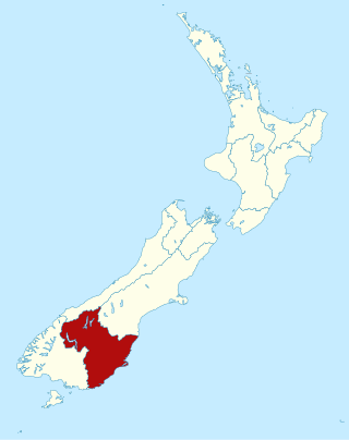
Otago is a region of New Zealand located in the southern half of the South Island administered by the Otago Regional Council. It has an area of approximately 32,000 square kilometres (12,000 sq mi), making it the country's second largest local government region. Its population was 254,600 in June 2023.

Oamaru is the largest town in North Otago, in the South Island of New Zealand, it is the main town in the Waitaki District. It is 80 kilometres (50 mi) south of Timaru and 120 kilometres (75 mi) north of Dunedin on the Pacific coast; State Highway 1 and the railway Main South Line connect it to both cities. With a population of 14,000, Oamaru is the 28th largest urban area in New Zealand, and the third largest in Otago behind Dunedin and Queenstown. The town is the seat of Waitaki District, which includes the surrounding towns of Kurow, Weston, Palmerston, and Hampden, which combined have a total population of 23,200.

The provinces of the Colony of New Zealand existed as a form of sub-national government. Initially established in 1846 when New Zealand was a Crown colony without responsible government, two provinces were first created. Each province had its own legislative council and governor. With the passing of the New Zealand Constitution Act 1852 the provinces were recreated around the six planned settlements or "colonies". By 1873 the number of provinces had increased to nine, but they had become less isolated from each other and demands for centralised government arose. In 1875 the New Zealand Parliament decided to abolish the provincial governments, and they came to an end in November 1876. They were superseded by counties, which were later replaced by territorial authorities.

The Waitaki River is a large braided river in the South Island of New Zealand. It drains the Mackenzie Basin and runs 209 kilometres (130 mi) south-east to enter the Pacific Ocean between Timaru and Oamaru on the east coast. It starts at the confluence of the Ōhau and Tekapo rivers, now at the head of the artificial Lake Benmore, these rivers being fed by three large glacial lakes, Pukaki, Tekapo, and Ōhau at the base of the Southern Alps. The Waitaki flows through Lake Benmore, Lake Aviemore and Lake Waitaki, these lakes being contained by hydroelectric dams, Benmore Dam, Aviemore Dam and Waitaki Dam. The Waitaki has several tributaries, notably the Ahuriri River and the Hakataramea River. It passes Kurow and Glenavy before entering the Pacific Ocean. The River lends its name the Waitaki District on the south side of the river bank.

The Main South Line, sometimes referred to as part of the South Island Main Trunk Railway, is a railway line that runs north and south from Lyttelton in New Zealand through Christchurch and along the east coast of the South Island to Invercargill via Dunedin. It is one of the most important railway lines in New Zealand and was one of the first to be built, with construction commencing in the 1860s. At Christchurch, it connects with the Main North Line to Picton, the other part of the South Island Main Trunk.
The Bluff Branch, officially the Bluff Line since 2011, is a railway line in Southland, New Zealand that links Invercargill with the port of Bluff. One of the first railways in New Zealand, it opened in 1867 and is still operating. Presently, it essentially functions as an elongated industrial siding.
Sir William Jukes Steward was a New Zealand politician and the first Liberal Speaker of the New Zealand House of Representatives. He represented South Canterbury electorates in Parliament for a total of 34 years, before being appointed to the Legislative Council. He served briefly on the Otago Provincial Council and was Mayor of Oamaru for three years.
The Canterbury Province was a province of New Zealand from 1853 until the abolition of provincial government in 1876. Its capital was Christchurch.

The Southland Province was a province of New Zealand from March 1861, when it split from Otago Province, until 1870, when it rejoined Otago.

The Southern Scenic Route is a tourist highway in New Zealand linking Queenstown, Fiordland, Te Anau and the iconic Milford Road to Dunedin via, Riverton, Invercargill and The Catlins. An Australian travel magazine labelled it "one of the world's great undiscovered drives" in 2008.

Waitaki is an electorate for the New Zealand House of Representatives that crosses the boundary of North Otago and South Canterbury towns on the East Coast of the South Island. The electorate was first established for the 1871 election that determined the 5th New Zealand Parliament. It has been abolished and re-established several times and in its early years was a two-member electorate for two parliamentary terms. The current electorate has existed since the 2008 election and is held by Miles Anderson of the National Party.

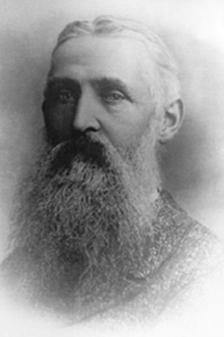
John Parkin Taylor was a 19th-century New Zealand runholder, and a politician in Otago and Southland. In his early life, Taylor lived in various countries and studied languages in Germany. He worked as a merchant and was married when he returned to England. Taylor's family emigrated to New Zealand in 1849 and he was a sheep farmer in various parts of the South Island before finally settling on a run near Riverton in Southland, where he had his homestead 'Waldeck' built. He entered the House of Representatives for the Dunedin Country electorate through a by-election in 1858 but fell out with many of his constituents over a broken election promise, as he helped the Southland Province to break away from the Otago Province. He eventually became Southland's second Superintendent and served from 1865 to 1869, and also represented an electorate on the Southland Provincial Council for a few months. In 1865, he was appointed to the New Zealand Legislative Council and with one break in membership due to non-attendance, he remained a member until his death. He served for one year as mayor of Riverton (1872–73) but did not stand again due to poor health. Taylor had a painful illness and died in 1875.
Awarua was a New Zealand parliamentary electorate from 1881 to 1996.
Scottish New Zealanders are New Zealanders of Scottish ancestry or who originate from Scotland. The number of New Zealanders who are descended from Scots is unknown, as the New Zealand census asks for ethnicity, not ancestry, and most have now assimilated; nonetheless, the vast majority of Pākehā, or European New Zealanders are of British and Irish descent, and it has been estimated that 1–2 million New Zealanders have roots in Scotland. This includes many Māori, as a large proportion of which have European roots as well. Most Scottish New Zealanders live in New Zealand's deep southern regions of Otago and Southland, New Zealand, where they have had a substantial influence. Scottish influence on Dunedin, one of New Zealand's most historically important cities was profound, and Presbyterianism is the major religion south of Christchurch. In some parts of Otago and all of Southland, there is a distinct accent known as the "Southland burr", which differs from mainstream New Zealand English for being strongly rhotic.

Samuel Edward Shrimski was a 19th-century Member of Parliament and then a Member of the Legislative Council from Otago, New Zealand.
The 8th New Zealand Parliament was a term of the New Zealand Parliament.
The Oamaru by-election 1885 was a by-election held in the Oamaru electorate during the 9th New Zealand Parliament, on 20 May 1885. The by-election was caused by the resignation of the incumbent, Samuel Shrimski, who was appointed to the Legislative Council, and was won by Thomas William Hislop.

The Southern District Health Board was a district health board which provided healthcare to an area covering the southern half of the South Island of New Zealand. In July 2022, the Southern DHB was dissolved as part of a nationwide overhaul of the district health board system. Its former functions and responsibilities were taken over by Te Whatu Ora.
