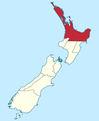
Marlborough Province

Last updated
Map showing the boundaries of the Marlborough Province Marlborough in New Zealand (1873).svg
Map showing the boundaries of the Marlborough Province
(For the current top-level subdivision of Nelson in New Zealand, see Marlborough region)

The Marlborough Province operated as a province of New Zealand from 1 November 1859, when it split away from Nelson Province, until the abolition of provincial government in 1876. [1]

Contents

History

Marlborough split away from the Nelson Province because the majority of the income of the Provincial Council came from land sales in the Marlborough region, but the funds were mostly used in the Nelson region. Land sales in Nelson and Marlborough netted the Nelson Provincial Council £33,000 and £160,000, respectively. Of that, £200 were expended benefiting the Marlborough region. Marlborough settlers successfully petitioned for a split from Nelson. [2] Another reason was that large landholders feared the growing influence of smaller farmers and urban residents. By splitting the Marlborough Province off with its large farms, it was easier for these landholders to control the provincial council. [3]

When the province was formed, Sir Thomas Gore Browne, the Governor of New Zealand, named it after John Churchill, 1st Duke of Marlborough. The settlement of Blenheim was subsequently named after the Battle of Blenheim (1704), where troops led by the Duke defeated a combined French and Bavarian force at the village of Blenheim (Blindheim) in Germany. [4]

Area

View from above looking north from Blenheim Blenheim New Zeland.jpg
View from above looking north from Blenheim

The Marlborough Province was notable for its intense personal rivalries among its politicians. This led to a farcical change of capital from at first Blenheim, then Picton from 1861, and back again to Blenheim from July 1865. [5] In a symbolic way, government buildings in both Blenheim and Picton burned down some months after the abolition of the provincial system. [5]

Marlborough was not systematically settled like other regions, but capital-rich settlers from the Nelson area spilled over who wanted to invest in large land holdings. Frederick Weld was the first in 1847 to land sheep at Port Underwood, a sheltered harbour which forms the north-east extension of Cloudy Bay in the Marlborough Sounds. Because of its early start in sheep farming, other South Island areas were stocked from here. [6]

Anniversary Day

New Zealand law provides an anniversary day for each former province. Marlborough celebrates its founding on a Monday near 1 November each year.

Superintendents

The Marlborough Province had five Superintendents: [7]

No.fromtoSuperintendent
11 May 186020 Jul 1861 William Adams
228 Aug 186118 Feb 1863 Captain Baillie
325 Mar 186330 Jul 1864 Thomas Carter
419 Sep 1864Oct 1865 Arthur Seymour [8]
523 Oct 1865Feb 1870 William Henry Eyes
28 Mar 187031 Oct 1876 [9] Arthur Seymour (2nd time)

Legislation

Related Research Articles

<span class="mw-page-title-main">Marlborough District</span> District and unitary authority of New Zealand

Marlborough District or the Marlborough Region, commonly known simply as Marlborough, is one of the 16 regions of New Zealand, located on the northeast of the South Island. Marlborough is a unitary authority, both a district and a region. Marlborough District Council is based at Blenheim, the largest town. The unitary region has a population of 51,900.

<span class="mw-page-title-main">Blenheim, New Zealand</span> Town in Marlborough, New Zealand

Blenheim is the most populous town in the region of Marlborough, in the north east of the South Island of New Zealand. It has an urban population of 29,000. The surrounding Marlborough wine region is well known as the centre of the New Zealand wine industry. It enjoys one of New Zealand's sunniest climates, with warm, relatively dry summers and cool, crisp winters.

<span class="mw-page-title-main">Hawke's Bay Province</span> Provinces of New Zealand in North Island

The Hawke's Bay Province was a province of New Zealand. The province separated from the Wellington Province following a meeting in Napier in February 1858, and existed until the abolition of provincial government in 1876. At the time of its establishment in 1858, the European population of the provincial district was only 1,185.

<span class="mw-page-title-main">Nelson Province</span> Provinces of New Zealand

Nelson Province was constituted in 1853 under the New Zealand Constitution Act 1852, and originally covered the entire upper South Island, including all of present-day Buller, Kaikoura, Marlborough, and Tasman districts, along with Nelson City, Grey District north of the Grey River, and the Hurunui District north of the Hurunui River. It was reduced in size by the creation of Marlborough Province in November 1859, then abolished in 1876, along with all the provinces of New Zealand.

<span class="mw-page-title-main">Westland Province</span> Former Province of New Zealand in South Island

The Westland Province was a province of New Zealand from 1873 until the abolition of provincial government in 1876. The capital was Hokitika.

<i>An Encyclopaedia of New Zealand</i> Official encyclopaedia about New Zealand

An Encyclopaedia of New Zealand is an official encyclopaedia about New Zealand, published in three volumes by the New Zealand Government in 1966. Edited by Alexander Hare McLintock, the parliamentary historian, assisted by two others, the encyclopaedia included over 1,800 articles and 900 biographies, written by 359 contributing authors.

<span class="mw-page-title-main">Roderick McKenzie</span> New Zealand politician

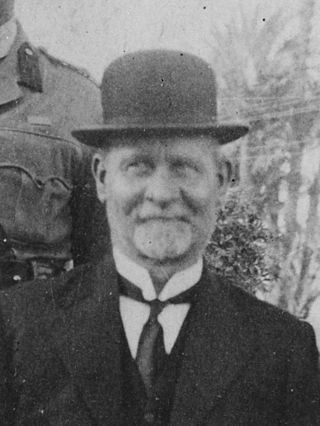
Roderick McKenzie was a New Zealand Member of Parliament for Buller and Motueka, in the South Island. He was a member of the Liberal Party.

<span class="mw-page-title-main">Arthur Seymour (politician)</span>

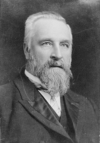
Arthur Penrose Seymour was a 19th-century New Zealand politician from Picton. He was the 4th Superintendent of the Marlborough Province and was a member of the provincial government for all 16 years of its existence. With his strong advocacy for Picton, he successfully had the Seat of Government moved to Picton. When the Blenheim party secured a majority in the Provincial Council by 1865, Seymour negotiated the removal of the Seat of Government back to Blenheim.

<span class="mw-page-title-main">Wakamarina River</span> River in New Zealand

The Wakamarina River is a river of the Marlborough Region of New Zealand's South Island. It flows generally northeast from its origins in the Richmond Range to reach the Pelorus River at the settlement of Canvastown, 10 kilometres (6 mi) west of Havelock. In 1864, gold was found in the river near Havelock, and soon 6,000 men were working in the area. The gold rush did not last long and most miners moved on to the West Coast Gold Rush.

Wairau was a parliamentary electorate in the Marlborough Region of New Zealand. It was one of the initial 24 New Zealand electorates and existed from 1853 until its abolition in 1938, when it was succeeded by the Marlborough electorate. The electorate had 13 representatives during its existence. The 1861 election in the Wairau electorate was notable in that a later Premier, Frederick Weld, was unexpectedly and narrowly defeated by William Henry Eyes.

Andrew James Richmond was a 19th-century Member of Parliament in Nelson, New Zealand.

<span class="mw-page-title-main">Grey County, New Zealand</span>

Grey County was one of the counties of New Zealand in the South Island.

<span class="mw-page-title-main">Mayor of Blenheim</span>

The mayor of Blenheim officiated over the borough of Blenheim, New Zealand. The office was created in 1869 when Blenheim became a borough, and ceased with the 1989 local government reforms, when Blenheim Borough was amalgamated with Picton Borough and Marlborough County Council to form Marlborough District. There were 31 mayors of Blenheim. The last mayor of Blenheim, Leo McKendry, was elected as the first mayor of Marlborough.

<span class="mw-page-title-main">Westland County</span> Provinces of New Zealand in South Island

Westland County, also known as County of Westland, was a local government area on the West Coast of New Zealand's South Island. It existed from 1868 to 1873, and then from 1876 until 1989. In its first incarnation it constituted the government for the area that was split from the Canterbury Province, with the West Coast Gold Rush having given the impetus for that split. It had the same administrative powers as a provincial council, but the legislative power rested with Parliament in Wellington. The first Westland County was the predecessor to Westland Province.

The Mayor of Grey, often referred to as the Mayor of Greymouth, officiates over the Grey District of New Zealand which is administered by the Grey District Council with its seat in Greymouth. The current Mayor is Tania Gibson. Two predecessors to this office were the Mayor of Greymouth, officiating over the Greymouth Borough Council from 1868, and from 1877 the chairman of the Grey County Council.

The Greymouth Borough was the borough council covering the urban part of Greymouth, New Zealand between 1868 and 1989, when it became part of Grey District.

<span class="mw-page-title-main">1875 Wairau by-election</span> New Zealand by-election

The 21 June 1875 Wairau by-election was a by-election held in the Wairau electorate in the Marlborough Province during the 5th New Zealand Parliament. The by-election was caused by the resignation of incumbent MP Arthur Seymour and was won by Joseph Ward, who defeated William Sefton Moorhouse. Ward was a well-known politician in Marlborough. Moorhouse had political seniority over Ward and was at the time Mayor of Wellington, but had no personal connection to Marlborough.

Marlborough County was one of the counties of New Zealand on the South Island.

The Third Fox Ministry was a responsible government which held power in New Zealand from June 1869 to September 1872. Although William Fox was the head of the government, he was never appointed Premier as that office had yet to be established, although he did resign the office at the end of his tenure. The Ministry was also known as the Fox-Vogel Ministry as most of the agenda was set by the Treasurer, while Fox busied himself with administrative affairs and moral crusades such as the attempted introduction of local option polls for liquor licensing.

The First Vogel Ministry was a responsible government which held power in New Zealand from April 1873 to July 1875.

References

  1. "Regions of New Zealand". Statoids. Retrieved 11 December 2013.
  2. "Superintendents of Marlborough". The Cyclopedia of New Zealand : Nelson, Marlborough & Westland Provincial Districts. Christchurch: Cyclopedia Company Limited. 1906. Retrieved 21 May 2010.
  3. McLintock, A. H., ed. (22 April 2009) [First published in 1966]. "Province and Provincial Districts". An Encyclopaedia of New Zealand . Ministry for Culture and Heritage / Te Manatū Taonga . Retrieved 11 December 2013.
  4. "Blenheim". New Zealand History. New Zealand Ministry for Culture and Heritage. Retrieved 11 October 2014.
  5. 1 2 McLintock, A. H., ed. (22 April 2009) [First published in 1966]. "Province and Provincial Districts". An Encyclopaedia of New Zealand . Ministry for Culture and Heritage / Te Manatū Taonga . Retrieved 11 December 2013.
  6. McLintock, A. H., ed. (22 April 2009) [First published in 1966]. "Province and Provincial Districts". An Encyclopaedia of New Zealand . Ministry for Culture and Heritage / Te Manatū Taonga . Retrieved 11 December 2013.
  7. "Provinces 1848–77". Rulers.org. Retrieved 16 September 2010.
  8. "Mr. Arthur Penrose Seymour". The Cyclopedia of New Zealand : Nelson, Marlborough & Westland Provincial Districts. Christchurch: Cyclopedia Company Limited. 1906. Retrieved 21 May 2010.
  9. Scholefield, Guy Hardy (1925) [First published in 1913]. New Zealand Parliamentary Record (2nd ed.). Wellington: Govt. Printer. p. 203.

41°30′50″S173°57′36″E / 41.514°S 173.960°E / -41.514; 173.960 Coordinates: 41°30′50″S173°57′36″E / 41.514°S 173.960°E / -41.514; 173.960