
The Hutt Valley campaign was an armed conflict in the lower North Island of New Zealand between indigenous Māori and British settlers and military forces in 1846. The campaign was among the earliest of the 19th century New Zealand Wars that were fought over issues of land and sovereignty. It was preceded by the Wairau affray and followed by the Wanganui campaign and was triggered by much the same pressures—the careless land purchasing practices of the New Zealand Company, armed government support for settler land claims, and complex intertribal tensions between local Māori. The three conflicts also shared many of the same combatants.

Te Rauparaha was a Māori rangatira, warlord, and chief of the Ngāti Toa iwi. One of the most powerful military leaders of the Musket Wars, Te Rauparaha fought a war of conquest that greatly expanded Ngāti Toa southwards, receiving the epithet "the Napoleon of the South". He remains one of the most prominent and celebrated New Zealand historical figures.
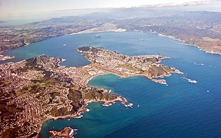
Wellington Harbour, officially called Wellington Harbour / Port Nicholson, is a large natural harbour on the southern tip of New Zealand's North Island. The harbour entrance is from Cook Strait. Central Wellington is located on parts of the western and southern sides of the harbour, and the suburban area of Lower Hutt is to the north and east.

Te Koko-o-Kupe / Cloudy Bay is located at the northeast of New Zealand's South Island, to the south of the Marlborough Sounds and north of Clifford Bay. In August 2014, the name Cloudy Bay, given by Captain Cook in 1770, was officially altered to Te Koko-o-Kupe / Cloudy Bay, with the Māori name recalling the early explorer Kupe scooping up oysters from the bay. The area lends its name to one of the best known New World white wines although the grapes used in production of that wine are grown in the Marlborough wine region further inland.
The history of the Canterbury Region of the South Island of New Zealand dates back to settlement by Māori people in about the 14th century.
1840 is considered a watershed year in the history of New Zealand: The Treaty of Waitangi is signed, British sovereignty over New Zealand is proclaimed, organised European settlement begins, and Auckland and Wellington are both founded.
The following lists events that happened during 1834 in New Zealand.
The following lists events that happened during 1831 in New Zealand.
John Guard was an English convict sent to Australia who was one of the first European settlers in the South Island of New Zealand, working as a whaler and trader.
The following lists events that happened during 1830 in New Zealand.
The following lists events that happened during 1828 in New Zealand.
The following lists events that happened during 1827 in New Zealand.
The following lists events that happened during 1826 in New Zealand.
The following lists events that happened during 1822 in New Zealand.
The following lists events that happened during 1820 in New Zealand.
There is a drastic decline in the number of ships visiting New Zealand from the previous year. An economic depression starts in New South Wales as a result of the escalation of war in Europe and the consequent reduction in the number of convicts being transported. In March news of the Boyd massacre reaches Port Jackson and a punitive expedition is sent to New Zealand and bombards the village of the incorrectly blamed chief, Te Pahi. After this the few whaling ships that later head for New Zealand usually prefer to avoid landing, especially in the Bay of Islands.
Foveaux Strait is the centre of attention for sealing ships. Sealing gangs are dropped along the coast from southern Fiordland to Otago Harbour and on Stewart Island/Rakiura. The Bay of Islands is sometimes on the journey to or from Port Jackson. The Chatham Islands are also visited. A few whalers also operate around New Zealand; some also collect timber from Bay of Islands.
Sealing continues at Bass Strait and the Antipodes Islands. At the end of the year there is a new sealing rush to the Bounty and Auckland Islands. Few sealers, if any, are known to have visited the Foveaux Strait area at this time, although this may be due in part to the secrecy of the captains and owners in reporting where they operate and/or the existence of the Strait not yet being widely known. Whaling continues off the east coast of the North Island. Ships are now visiting the Bay of Islands on a reasonably regular basis. The first reports about the poor behaviour of ships crews are sent to the Church Missionary Society in London.
There is a lessening of the sealing rush at Bass Strait as the rookeries become thinner, and as a result sealers return to Dusky Sound and explore the surrounding coast. Little of the movements of these ships is actually recorded as a veil of secrecy still surrounds their activities while the various ships try to make the most of any discoveries before the competition arrives. They occasionally meet local Māori but little information regarding these encounters survives. There are again around half a dozen whalers off the north-east coast of New Zealand, a few of which call into the Bay of Islands. The first Māori to join a whaling ship, and possibly the first to leave New Zealand in 10 years, does so early in the year.

Edward Marsh Williams was a missionary, interpreter, and judge who played a significant role in the British colonisation of New Zealand. He was born in Hampstead, Middlesex, the eldest son of Archdeacon Henry Williams and Marianne Williams.

