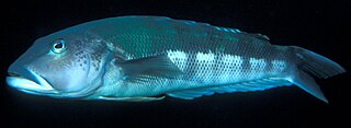
Long Island-Kokomohua Marine Reserve

Last updated
Long Island-Kokomohua Marine Reserve
Long Island, Marlborough Sounds.jpg
Long Island, as viewed from Motuara Island
New Zealand relief map.jpg
Disc Plain red.svg
Long Island-Kokomohua Marine Reserve
Location Marlborough Region, New Zealand
Nearest city Picton
Coordinates 41°07′09″S174°16′01″E / 41.1192583°S 174.2669572°E / -41.1192583; 174.2669572
Area619 hectares (1,530 acres)
Established1993
Governing body Department of Conservation

Long Island-Kokomohua Marine Reserve is a marine reserve, in the Marlborough Region of New Zealand's South Island. It covers an area of 619 hectares at the entrance to the Queen Charlotte Sound in the Marlborough Sounds. [1] [2] It was the first marine reserve established on the South Island. [3]

Contents

The reserve includes Long Island and the tiny Kokomohua Islands to its north, and a largely submerged reef which connects the islands and extends north-east about 500m. [2] The marine reserve extends an area a further 463 metres to the northeast, [4] where there are several rocky pinnacles in deep water. [2]

History

Pre-reserve history

In 1925, a ranger visited Long Island and recommended it become a reserve. A scenic reserve was established on the reserve the following year. [3]

In 1991, local divers recommended the area around the reserve be turned into a marine reserve. [3] [5] Commercial and recreational fishing was stopped in 1992. [6]

Reserve history

The reserve was formally established in March 1993. [1] [7]

In March 2011, a study commissioned by the Department of Conservation found more large blue cod than at any point in the previous 17 years. [8]

In 2014, a study commissioned by the Department of Conservation identified found marine life had become larger, changed their structure, become more abundant, had become more widely distributed, and changes to their behaviour. [9]

In March 2016, a report by the National Institute of Water and Atmospheric Research identified a dramatic recovery of fish stocks following the end of commercial and recreational fishing. Predatory blue cod has increased by three times, blue moki had increased by 1.4 times, rock lobster had increased by 11.5 times, grazing black foot pāua has increased 1.4 times. There was also two thirds less grazing kina, especially small kina. It concluded this change reflected the resilience of the ecosystem, and the potential for restoration outside the reserve. [6]

In July 2020, the National Institute of Water and Atmospheric Research identified microplastics on the sea floor of the marine reserve. [10]

Wildlife

Large blue cod are abundant in the reserve. [2] The reserve protects fish and shellfish, and seals, penguins and seabirds that feed in the sea. [11] In January 2022, 50 fluttering shearwater (Puffinus gavia) or pakahā chicks were translocated from the reserve to the newly-established Wharariki Ecosanctuary at Cape Farewell [12] They were the first species to be introduced to the new sanctuary. [13]

The rocky pinnacles are a habitat for schools of butterfly perch, tarakihi, rock lobster, blue cod, seaweed, sea sponges, and some dolphins and seals. [2] [11]

Recreation

The reserve is only accessible by boat from Picton. Activities include boating, swimming, snorkelling, and scuba-diving near the rocky reefs on the north-facing shore. [14] Unmarked reefs, tidal changes, strong currents, strong winds and sudden changes in sea conditions can be hazardous. [2] The rocky reefs are a popular feature for divers. [11]

Fishing, and taking or killing in other marine life, is not permitted. However, tangata whenua may access the reserve to remove nephrite and serpentine. [2]

There is no formal count of how many people visit the reserve, but evidence from compliance work suggested there were fewer recreational boats visiting the area by 2000, than before the park was established in 1993. [15]

See also

Related Research Articles

<span class="mw-page-title-main">Kaikōura</span> Town in the South Island of New Zealand

Kaikōura is a town on the east coast of the South Island of New Zealand. It is located on State Highway 1, 180 km north of Christchurch. The town has an estimated permanent resident population of 2,360.

<span class="mw-page-title-main">Marine reserves of New Zealand</span>

New Zealand has 44 marine reserves spread around the North, the South Island, and neighbouring islands, and on outlying island groups. They are governed by the Marine Reserves Act 1971 and administered by the Department of Conservation with assistance from the Ministry of Fisheries, New Zealand Customs and the New Zealand Defence Forces.

<span class="mw-page-title-main">Long Island (Marlborough)</span> Island in Queen Charlotte Sound in New Zealand

Long Island is located in Queen Charlotte Sound, one of the Marlborough Sounds of New Zealand. James Cook recorded its original name as Hamote.

<span class="mw-page-title-main">Cape Rodney-Okakari Point Marine Reserve</span>

Cape Rodney-Okakari Point Marine Reserve is a 5.5 km2 (2.1 sq mi) protected area in the North Island of New Zealand.

Hawea Marine Reserve is a marine reserve covering an area of 411 hectares in Hāwea / Bligh Sound, in Fiordland on New Zealand's South Island. It was established in 2005 and is administered by the Department of Conservation.

<span class="mw-page-title-main">Ulva Island-Te Wharawhara Marine Reserve</span>

Ulva Island-Te Wharawhara Marine Reserve is a marine reserve covering an area of 1,075 hectares south-west and north-east of Ulva Island, in the Paterson Inlet of New Zealand's Stewart Island. It was established in 2004 and is administered by the Department of Conservation.

<span class="mw-page-title-main">Hikurangi Marine Reserve</span> New Zealand marine reserve

Hikurangi Marine Reserve is a marine reserve off the coast of the Kaikōura District, in the Canterbury Region of New Zealand's South Island. It is the largest and deepest marine reserve in New Zealand.

<span class="mw-page-title-main">Waiau Glacier Coast Marine Reserve</span> Marine reserve in West Coast Region, New Zealand

Waiau Glacier Coast Marine Reserve is a marine reserve of the West Coast Region of New Zealand's South Island. It covers an area of 4,641 hectares or 46 km2, from 11 km south from Kohuamarua Bluff near Ōkārito, to Omoeroa Bluff, and about 4 km out to sea.

<span class="mw-page-title-main">Parininihi Marine Reserve</span>

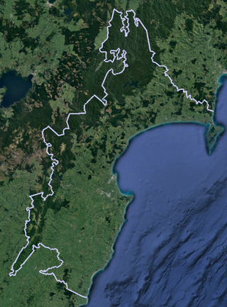
Parininihi Marine Reserve is a marine reserve administered by the Department of Conservation, covering 1,800 hectares in the North Taranaki Bight. It is located offshore of the west coast of New Zealand's North Island, north-east of New Plymouth.

<span class="mw-page-title-main">Punakaiki Marine Reserve</span>

Punakaiki Marine Reserve is a marine reserve administered by the Department of Conservation. The reserve includes the area of sea surrounding the pancake rocks and blowholes at Dolomite Point, at Punakaiki on the West Coast Region of New Zealand's South Island. It also includes most of the coastline on the western edge of Paparoa National Park.

<span class="mw-page-title-main">Te Angiangi Marine Reserve</span>

Te Angiangi Marine Reserve is a marine reserve covering a marine area of 446 hectares in the Hawke's Bay Region of New Zealand's North Island. It was established in 1997 and is administered by the Department of Conservation.

<span class="mw-page-title-main">Moutere Mahue / Antipodes Island Marine Reserve</span> Marine reserve in New Zealand territorial waters

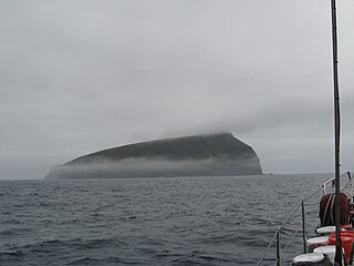
Moutere Mahue / Antipodes Island Marine Reserve is a marine reserve covering an area of 217,287 hectares around the Antipodes Islands south of New Zealand's South Island and Stewart Island / Rakiura. It was established in 2014 and is administered by the New Zealand Department of Conservation.

Moutere Hauriri / Bounty Islands Marine Reserve is a marine reserve covering an area of 104,626 hectares around New Zealand's Bounty Islands. It was established in 2014 and is administered by the Department of Conservation.

<span class="mw-page-title-main">Westhaven (Te Tai Tapu) Marine Reserve</span>

Westhaven Marine Reserve is a marine reserve covering an area of 536 hectares in the Whanganui Inlet at the top of New Zealand's South Island. It was established in 1994 and is administered by the Department of Conservation.

Kahukura Marine Reserve is a marine reserve covering an area of 464 hectares in Charles Sound, in Fiordland on New Zealand's South Island. It was established in 2005 and is administered by the Department of Conservation.

<span class="mw-page-title-main">Taumoana (Five Finger Peninsula) Marine Reserve</span>

Taumoana Marine Reserve is a marine reserve covering an area of 464 hectares in Fiordland on New Zealand's South Island. It was established in 2005 and is administered by the Department of Conservation. It is located next to the Five Fingers Peninsula, at the entrance to Tamatea / Dusky Sound.

<span class="mw-page-title-main">Moana Uta (Wet Jacket Arm) Marine Reserve</span> Marine reserve in New Zealand territorial waters

Moana Uta Marine Reserve is a marine reserve covering the entire length of Wet Jacket Arm in Fiordland on New Zealand's South Island, an area of 2,007 hectares. It was established in 2005 and is administered by the Department of Conservation.

<span class="mw-page-title-main">Piopiotahi (Milford Sound) Marine Reserve</span>

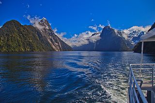
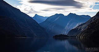
Piopiotahi Marine Reserve is a marine reserve covering an area of 690 hectares in the Milford Sound / Piopiotahi, in Fiordland on New Zealand's South Island. It was established in 1993 and is administered by the Department of Conservation.

<span class="mw-page-title-main">Te Awaatu Channel (The Gut) Marine Reserve</span>

Te Awaatu Channel Marine Reserve is a marine reserve covering an area of 93 hectares in Fiordland on New Zealand's South Island. It was established in 1993 and is administered by the Department of Conservation.

<span class="mw-page-title-main">Wharariki Ecosanctuary</span>

Wharariki Ecosanctuary is a wildlife sanctuary within a predator-proof fence at Cape Farewell, New Zealand.

References

  1. 1 2 "Marine protected areas". Te Ara - the Encyclopedia of New Zealand . Ministry for Culture and Heritage.
  2. 1 2 3 4 5 6 7 "Long Island-Kokomohua Marine Reserve". doc.govt.nz. Department of Conservation.
  3. 1 2 3 Baldwin, Andy (29 November 2019). "Wartime relics and spooky submarine stations rediscovered on Sounds voyage". stuff.co.nz. Marlborough Express.
  4. "Long Island - Kokomohua Marine Reserve Maps & boundaries". doc.govt.nz. Department of Conservation.
  5. "Long Island Submarine monitoring station". theprow.org.nz. Nelson City Council.
  6. 1 2 "History of benthic change in Queen Charlotte Sound/Totaranui, Marlborough" (PDF). envirolink.govt.nz. National Institute of Water and Atmospheric Research. March 2016.
  7. "Marine Reserve (Long Island—Kokomohua) Order 1993". legislation.govt.nz. New Zealand Government.
  8. Butterfield, Tania (25 May 2011). "Blue cod 'biggest in 17 years'". stuff.co.nz. Marlborough Express.
  9. Davidson, Robert (2014). Long Island-Kokomohua Marine Reserve, Queen Charlotte Sound: Update of Biological Monitoring 1992-2014 (PDF). Nelson: Davidson Environmental Limited.
  10. "Study Discovers Microplastics In New Zealand's Seabed". scoop.co.nz. National Institute of Water and Atmospheric Research. 16 July 2021.
  11. 1 2 3 Sivertsen, Juliette (17 December 2020). "New Zealand's best snorkel and dive locations". New Zealand Media and Entertainment. New Zealand Herald.
  12. Sivignon, Cherie (20 January 2022). "First fluttering shearwater chicks arrive at Cape Farewell sanctuary". Stuff. Archived from the original on 26 January 2022. Retrieved 26 January 2022.
  13. Gee, Samantha (23 January 2022). "Hope seabirds establish new colony at Cape Farewell Sanctuary". RNZ. Archived from the original on 17 February 2022. Retrieved 18 April 2022.
  14. Curzon, Kathryn (17 March 2020). "Top 10 NZ marine reserves to visit". stuff.co.nz. Stuff Travel.
  15. McCrone, Ann (March 2001). Visitor Impacts on Marine Protected Areas of New Zealand. Wellington: Department of Conservation.