Ulva Island-Te Wharawhara Marine Reserve

Last updated

Ulva Island-Te Wharawhara Marine Reserve
Stewart Island Ulva Island Ferry jetty.jpg
The marine reserve includes areas between Ulva Island in the foreground and Native Island in the background
NZ-SI plain map.png
Disc Plain red.svg
Location Southland, New Zealand
Coordinates 46°54′58″S168°01′03″E / 46.9162378°S 168.017473°E / -46.9162378; 168.017473
Area1,075 hectares (2,660 acres)
Established2004
Governing body Department of Conservation

Ulva Island-Te Wharawhara Marine Reserve is a marine reserve covering an area of 1,075 hectares (2,660 acres) south-west and north-east of Ulva Island, in the Paterson Inlet of New Zealand's Stewart Island. It was established in 2004 and is administered by the Department of Conservation. [1] [2]

Contents

Geography

The reserve covers about 15% of Paterson Inlet (Whaka ā Te Wera), [3] a submerged ancient river valley. [1] The rivers flowing into it drain from pristine undeveloped land with little sediment and nutrient run-off, and warm subtropical and cool Antarctic waters mix in the currents of Stewart Island. The combination of factors provides a habitat for a range of plants and animals including at least 56 species of marine fish. [1]

The inlet is one of the largest sheltered harbours in southern New Zealand. [4]

History

The marine reserve was established in 2004, [5] receiving legal recognition on 13 December of that year. [6]

The rest of Paterson Inlet was designated Te Whaka a Te Wera Mätaitai Reserve on 31 December 2004 to promote sustainable management of the inlet's fisheries resources and provide for customary food gathering by Maori. [7] It is closed off to non-commercial fishing. [8]

A fisher was fined for taking two blue cod from the reserve in December 2012. [9]

In 2019 the ecosystem of the marine reserve was in good health. [10]

Flora and fauna

Brachiopod (lamp shells), an ancient filter-feeding shellfish that live on both rock and sediment, thrive in the inlet at depths of less than 20 metres. [1] These shellfish were abundant in prehistoric oceans 300 to 550 million years ago, but are now relatively rare. The inlet is one of the most accessible viewing spots for the shellfish in the world. [4]

Kina, sea cucumbers and starfish also thrive in the inlet waters. [11] Divers also encounter carpet shark, Banded Wrasse, Stewart Island blue cod and lion's mane jellyfish. [12]

The inlet also has the widest variety of seaweed in New Zealand, including 56 brown, 31 green and 174 red species. The seaweed forests provide a habitat for a diverse range of fish, invertebrates and marine mammals. Meadows of small red seaweed grow on the sand, helping to stabilise the sediment while providing an important shelter for scallops and surface for spat and larvae. [1] [4] There is also a forest of giant kelp (Macrocystis pyrifera). [13]

Fur seals, sea lions and yellow-eyed penguins often visit the inlet. [4]

Recreation

The marine reserve is used for snorkelling, boating and kayaking, with clear waters teeming with fish, penguins and a variety of marine flora. [1] There are several boat launching ramps at Oban. [4]

According to the Department of Conservation, snorkelling is best at a depth of 5 to 12 metres, off the north end of Sydney Cove beach on Ulva Island. A wetsuit, flashlight and dive knife is recommended due to the kelp forests and cold sea temperatures. [1] The southern side of the island is best for kayaking and canoeing. [14]

Catch bags, fishing spears and fishing are banned in the reserve. Boats must take care when anchoring to avoid damaging the sea floor. [1]

The Ulva Island beaches are a 10-minute boat or water taxi ride from Golden Bay, and via well-formed gravel tracks on the island: Sydney Cove is a five-minute walk from the Ulva Island Wharf; Boulder Beach is a 30-minute walk across the island. [4]

See also

Related Research Articles

<span class="mw-page-title-main">Rakiura National Park</span> National park in New Zealand

Rakiura National Park is a nature reserve park located on Stewart Island / Rakiura, New Zealand. It is the newest national park of New Zealand and opened in 2002. The protected area covers about 85% of the island.

Paterson Inlet / Whaka a Te Wera is a large natural harbour in the eastern coast of Stewart Island/Rakiura, New Zealand, much of which is unspoilt forest.

<span class="mw-page-title-main">Aquaculture in New Zealand</span>

Aquaculture started to take off in New Zealand in the 1980s. It is dominated by mussels, oysters and salmon. In 2007, aquaculture generated about NZ$360 million in sales on an area of 7,700 hectares. $240 million was earned in exports.

<span class="mw-page-title-main">Cape Rodney-Okakari Point Marine Reserve</span>

Cape Rodney-Okakari Point Marine Reserve is a 5.5 km2 (2.1 sq mi) protected area in the North Island of New Zealand.

Hawea Marine Reserve is a marine reserve covering an area of 411 hectares in Hāwea / Bligh Sound, in Fiordland on New Zealand's South Island. It was established in 2005 and is administered by the Department of Conservation.

Long Island-Kokomohua Marine Reserve is a marine reserve, in the Marlborough Region of New Zealand's South Island. It covers an area of 619 hectares at the entrance to the Queen Charlotte Sound in the Marlborough Sounds. It was the first marine reserve established on the South Island.

<span class="mw-page-title-main">Moutere Ihupuku / Campbell Island Marine Reserve</span>

Moutere Ihupuku / Campbell Island Marine Reserve or Campbell Island / Moutere Ihupuku Marine Reserve is a marine reserve around Campbell island in the New Zealand Subantarctic Islands.

<span class="mw-page-title-main">Tāwharanui Marine Reserve</span>

Tāwharanui Marine Reserve is a marine reserve covering an area of 394 hectares in the Hauraki Gulf, offshore from the Tāwharanui Peninsula in the Auckland Region of New Zealand's North Island. It was established in 2011 and is administered by the Department of Conservation.

<span class="mw-page-title-main">Te Angiangi Marine Reserve</span>

Te Angiangi Marine Reserve is a marine reserve covering a marine area of 446 hectares in the Hawke's Bay Region of New Zealand's North Island. It was established in 1997 and is administered by the Department of Conservation.

<span class="mw-page-title-main">Te Paepae o Aotea (Volkner Rocks) Marine Reserve</span> Marine reserve in New Zealand territorial waters

Te Paepae o Aotea Marine Reserve is a marine reserve covering an area of 1,267 hectares in the Bay of Plenty of New Zealand's North Island. It includes an area around Te Paepae o Aotea, 55 kilometres (34 mi) north-northwest of Whakatāne and 5 kilometres (3.1 mi) northwest of Whakaari/White Island.

<span class="mw-page-title-main">Moutere Mahue / Antipodes Island Marine Reserve</span> Marine reserve in New Zealand territorial waters

Moutere Mahue / Antipodes Island Marine Reserve is a marine reserve covering an area of 217,287 hectares around the Antipodes Islands south of New Zealand's South Island and Stewart Island / Rakiura. It was established in 2014 and is administered by the New Zealand Department of Conservation.

<span class="mw-page-title-main">Westhaven (Te Tai Tapu) Marine Reserve</span>

Westhaven Marine Reserve is a marine reserve covering an area of 536 hectares in the Whanganui Inlet at the top of New Zealand's South Island. It was established in 1994 and is administered by the Department of Conservation.

Kahukura Marine Reserve is a marine reserve covering an area of 464 hectares in Charles Sound, in Fiordland on New Zealand's South Island. It was established in 2005 and is administered by the Department of Conservation.

<span class="mw-page-title-main">Kutu Parera (Gaer Arm) Marine Reserve</span> Marine reserve in Fiordland, South Island, New Zealand

Kutu Parera Marine Reserve is a marine reserve covering an area of 433 hectares at Gaer Arm in the Bradshaw Sound of Fiordland on New Zealand's South Island. It was established in 2005 and is administered by the Department of Conservation.

<span class="mw-page-title-main">Taumoana (Five Finger Peninsula) Marine Reserve</span>

Taumoana Marine Reserve is a marine reserve covering an area of 464 hectares in Fiordland on New Zealand's South Island. It was established in 2005 and is administered by the Department of Conservation. It is located next to the Five Fingers Peninsula, at the entrance to Tamatea / Dusky Sound.

<span class="mw-page-title-main">Te Tapuwae o Hua (Long Sound) Marine Reserve</span>

Te Tapuwae o Hua Marine Reserve is a marine reserve covering an area of 3,672 hectares in Te Awaroa / Long Sound in Fiordland on New Zealand's South Island. It was established in 2005 and is administered by the Department of Conservation.

<span class="mw-page-title-main">Moana Uta (Wet Jacket Arm) Marine Reserve</span> Marine reserve in New Zealand territorial waters

Moana Uta Marine Reserve is a marine reserve covering the entire length of Wet Jacket Arm in Fiordland on New Zealand's South Island, an area of 2,007 hectares. It was established in 2005 and is administered by the Department of Conservation.
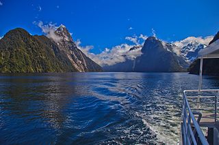
<span class="mw-page-title-main">Taipari Roa (Elizabeth Island) Marine Reserve</span> Marine reserve in New Zealand territorial waters

Taipari Roa Marine Reserve is a marine reserve covering an area of 613 hectares around Elizabeth Island, in the inner Doubtful Sound / Patea of Fiordland on New Zealand's South Island. It was established in 2005 and is administered by the Department of Conservation.

<span class="mw-page-title-main">Te Awaatu Channel (The Gut) Marine Reserve</span>

Te Awaatu Channel Marine Reserve is a marine reserve covering an area of 93 hectares in Fiordland on New Zealand's South Island. It was established in 1993 and is administered by the Department of Conservation.

Native Island is off the east coast of Halfmoon Bay, Stewart Island, New Zealand. It is north east of Ulva Island in the northern mouth of Paterson Inlet. It is separated from Stewart Island by a narrow channel 50 metres (160 ft) in width. There has been evidence of small and temporary past Māori settlements on the island. Multiple Māori relics have been found, including bone fish hooks, axes, and chisels. Native Island is part of the Ulva Island-Te Wharawhara Marine Reserve, which is on the south part of Native Island.

References

  1. 1 2 3 4 5 6 7 8 "Ulva Island - Te Wharawhara Marine Reserve". doc.govt.nz. Department of Conservation.
  2. Hutching, Gerard. "Marine protected areas". Te Ara - the Encyclopedia of New Zealand . Ministry for Culture and Heritage.
  3. "Ulva Island/Te Wharawhara Marine Reserve". southlandnz.com. Tourism Southland.
  4. 1 2 3 4 5 6 "Ulva Island - Te Wharawhara Marine Reserve Brochure" (PDF). doc.govt.nz. Department of Conservation.
  5. "Marine reserve created off Stewart Island". NZ Herald. 4 June 2004. ISSN   1170-0777 . Retrieved 20 September 2020.
  6. "Marine Reserve (Ulva Island—Te Wharawhara) Order 2004". legislation.govt.nz. New Zealand Government.
  7. "New Stewart Island fisheries reserve becomes a reality". New Zealand Government. Beehive. 31 December 2004.
  8. Walrond, Carl. "Stewart Island/Rakiura". Te Ara - the Encyclopedia of New Zealand . Ministry for Culture and Heritage.
  9. "Fisherman in marine reserve fined". Fairfax New Zealand. Southland Times. 4 December 2012.
  10. Warren, Rhiannon (2019). Turning tides in New Zealand intertidal research: a baseline study of Ulva Island intertidal zones (PDF). Southern Institute of Technology.
  11. "Ulva Island / Te Wharawhara Marine Reserve". newzealand.com. Tourism New Zealand.
  12. Kany, Jessica (March 2020). ""front page"" (PDF). Stewart Island News.
  13. "Ecosystem explorations – Environment Southland". www.es.govt.nz. Retrieved 20 September 2020.
  14. "Ulva Island-Te Wharawhara Marine Reserve". aa.co.nz. Automobile Association of New Zealand.