Riversdale, New Zealand

Last updated

Riversdale
Riversdale, New Zealand
Coordinates: 45°54′S168°44′E / 45.900°S 168.733°E / -45.900; 168.733
CountryNew Zealand
Island South Island
Region Southland region
Territorial authorities of New Zealand Southland District
WardMararoa Waimea Ward
CommunityArdlussa Community
Electorates
Government
  Territorial authority Southland District Council
  Regional council Southland Regional Council
   Mayor of Southland Rob Scott
   Southland MP Joseph Mooney
   Te Tai Tonga MP Tākuta Ferris
Area
[1]
  Total1.69 km2 (0.65 sq mi)
Population
 (June 2023) [2]
  Total440
  Density260/km2 (670/sq mi)

Riversdale is a small town in the Southland region of New Zealand.

Contents

Geography

Riversdale is located between the Hokonui Hills and the Mataura River in the heart of the Waimea Plains, and is roughly equidistant between Gore and Lumsden on State Highway 94, the main road linking Gore with the tourist destination of Milford Sound.

In terms of climate, Riversdale has a temperate oceanic climate grading onto a continental climate more commonly found in Central Otago, with cold, wet winters and warm summers. The Riversdale region is one of the few areas in Southland prone to drought during the summer months.

Demographics

Riversdale is described as a rural settlement by Statistics New Zealand. It covers 1.69 km2 (0.65 sq mi), [1] and had an estimated population of 440 as of June 2023, [2] with a population density of 260 people per km2. It is part of the much larger Riversdale-Piano Flat statistical area.

Historical population for Riversdale
YearPop.±% p.a.
2006408    
2013399−0.32%
2018408+0.45%
Source: [3]

Riversdale had a population of 408 at the 2018 New Zealand census, an increase of 9 people (2.3%) since the 2013 census, and unchanged since the 2006 census. There were 168 households, comprising 207 males and 201 females, giving a sex ratio of 1.03 males per female, with 78 people (19.1%) aged under 15 years, 63 (15.4%) aged 15 to 29, 174 (42.6%) aged 30 to 64, and 93 (22.8%) aged 65 or older.

Ethnicities were 89.0% European/Pākehā, 13.2% Māori, 1.5% Pasifika, 3.7% Asian, and 1.5% other ethnicities. People may identify with more than one ethnicity.

Although some people chose not to answer the census's question about religious affiliation, 47.1% had no religion, 47.1% were Christian and 0.7% had other religions.

Of those at least 15 years old, 30 (9.1%) people had a bachelor's or higher degree, and 93 (28.2%) people had no formal qualifications. 60 people (18.2%) earned over $70,000 compared to 17.2% nationally. The employment status of those at least 15 was that 165 (50.0%) people were employed full-time, 51 (15.5%) were part-time, and 6 (1.8%) were unemployed. [3]

Riversdale-Piano Flat

Riversdale-Piano Flat statistical area covers 1,578.74 km2 (609.55 sq mi) [1] and also includes Waikaia. It had an estimated population of 1,500 as of June 2023, [4] with a population density of 1.0 people per km2.

Historical population for Riversdale-Piano Flat
YearPop.±% p.a.
20061,299    
20131,341+0.46%
20181,374+0.49%
Source: [5]

Riversdale-Piano Flat had a population of 1,374 at the 2018 New Zealand census, an increase of 33 people (2.5%) since the 2013 census, and an increase of 75 people (5.8%) since the 2006 census. There were 540 households, comprising 735 males and 639 females, giving a sex ratio of 1.15 males per female. The median age was 36.5 years (compared with 37.4 years nationally), with 303 people (22.1%) aged under 15 years, 249 (18.1%) aged 15 to 29, 606 (44.1%) aged 30 to 64, and 216 (15.7%) aged 65 or older.

Ethnicities were 92.1% European/Pākehā, 10.5% Māori, 1.1% Pasifika, 3.7% Asian, and 1.1% other ethnicities. People may identify with more than one ethnicity.

The percentage of people born overseas was 10.3, compared with 27.1% nationally.

Although some people chose not to answer the census's question about religious affiliation, 48.3% had no religion, 44.8% were Christian, 0.2% were Hindu and 0.7% had other religions.

Of those at least 15 years old, 129 (12.0%) people had a bachelor's or higher degree, and 246 (23.0%) people had no formal qualifications. The median income was $39,900, compared with $31,800 nationally. 189 people (17.6%) earned over $70,000 compared to 17.2% nationally. The employment status of those at least 15 was that 642 (59.9%) people were employed full-time, 186 (17.4%) were part-time, and 24 (2.2%) were unemployed. [5]

Railway

In 1880, the Waimea Plains Railway was opened; it linked Gore on the Main South Line with Lumsden on the Kingston Branch and passed through Riversdale. The line was an important economic link for many years, and the original Kingston Flyers that gave their name to today's Kingston Flyer tourist train in Kingston passed through Riversdale on their way to Gore or Dunedin from the 1890s through to Easter 1957.

With the improvement of road transportation and changes in government regulations, the railway lost its profitability, and in 1971, most of the line was closed, including the section through Riversdale. [6]

Education

Riversdale School is a state full primary school for years 1 to 8 [7] with a roll of 135 as of February 2024. [8] The school first opened in 1882. [9]

Related Research Articles

<span class="mw-page-title-main">Tasman District</span> Government district of New Zealand

Tasman District is a local government district in the northwest of the South Island of New Zealand. It borders the Canterbury Region, West Coast Region, Marlborough Region and Nelson City. It is administered by the Tasman District Council, a unitary authority, which sits at Richmond, with community boards serving outlying communities in Motueka and Golden Bay / Mohua. The city of Nelson has its own unitary authority separate from Tasman District, and together they comprise a single region in some contexts, but not for local government functions or resource management (planning) functions.

<span class="mw-page-title-main">Murchison, New Zealand</span> Town in Tasman, New Zealand

Murchison is a town in the Tasman Region of the South Island of New Zealand. It is near the western end of the "Four Rivers Plain", at the confluence of the Buller River and the Mātakitaki River. The other two rivers are the Mangles River, and the Matiri River. It is a rural service town for the surrounding mixed farming district, approximately halfway between Westport and Nelson. Murchison was named after the Scottish geologist Roderick Murchison, one of the founders of the Royal Geographical Society.

<span class="mw-page-title-main">Thames-Coromandel District</span> Territorial authority district in Waikato, New Zealand

The Thames-Coromandel District is a territorial authority district in the North Island of New Zealand, covering all the Coromandel Peninsula and extending south to Hikutaia.

<span class="mw-page-title-main">Richmond, Tasman</span> Town in Tasman District, New Zealand

Richmond is a town and the seat of the Tasman District Council in New Zealand. It lies 13 kilometres (8 mi) south of Nelson in the South Island, close to the southern extremity of Tasman Bay. The town, first settled by Europeans in 1842, was named in 1854 after the town of Richmond on Thames near London. The town has an estimated population of 19,200 as of June 2023.

<span class="mw-page-title-main">Tapanui</span> Town in Otago, New Zealand

Tapanui is a small town in West Otago in New Zealand's South Island, close to the boundary with Southland region.

<span class="mw-page-title-main">Lumsden, New Zealand</span> Town in the South Island of New Zealand

Lumsden is a town in Southland, New Zealand. Lying in a gap in the surrounding hills, Lumsden is the location of a major junction on State Highway 6. Lumsden is 81 kilometres north of Invercargill, 106 kilometres south of Queenstown, 59 kilometres west of Gore and 77 kilometres east of Te Anau.

<span class="mw-page-title-main">Kingston, New Zealand</span> Rural settlement in Otago, New Zealand

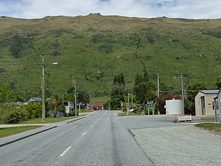
Kingston is a small town at the southernmost end of Lake Wakatipu, just north of the border of Otago and Southland, in New Zealand's South Island. It is 47 kilometres south of Queenstown by a road, "The Devil's Staircase", which winds between the lake to the west and The Remarkables mountains to the east. It is 70 kilometres north of Lumsden, and close to the headwaters of the Mataura River.

<span class="mw-page-title-main">Otematata</span> Town in the Waitaki District of Otago in New Zealands South Island

Otematata is a town in the Waitaki District of Otago in New Zealand's South Island. It is defined as a "populated area less than a town" and the 2001 New Zealand census gave the "usually resident population count" as 243. By the 2018 census it had declined to 183 inhabitants. This was considerably higher in the 1960s during the construction of the Benmore and Aviemore dams.

<span class="mw-page-title-main">Ettrick, New Zealand</span> Town in the South Island of New Zealand

Ettrick is a small town in inland Otago, in the South Island of New Zealand.

Balfour is a small town located in the Southland region of New Zealand.

<span class="mw-page-title-main">Kaka Point</span> Rural settlement in Otago, New Zealand

Kaka Point is a small town at the northern edge of The Catlins, an area of the southern South Island of New Zealand. It is located 14km south of Balclutha and 8km north of the headland of Nugget Point. It has a seasonally fluctuating population, and there are numerous cribs at the settlement. The settlement's best−known resident was Māori poet Hone Tuwhare, who lived in Kaka Point for many years until he died in 2008. Kaka Point is named for the kākā bird, whose signature call is "ka-aa."

<span class="mw-page-title-main">Clinton, New Zealand</span> Town in Otago, New Zealand

Clinton is a small town in South Otago, in New Zealand's South Island. Handy to the Catlins, Dunedin, Lawrence, Central Otago and Tapanui. It is located on State Highway 1 approximately halfway between Balclutha and Gore, and the Main South Line railway passes through the town.

<span class="mw-page-title-main">Kaipara Flats</span> Place in Auckland Region, New Zealand

Kaipara Flats is a locality in the Rodney District of New Zealand. Warkworth is 12 km to the east, Ahuroa to the south, and Tauhoa to the north-west. The North Auckland railway line passes through the area.

<span class="mw-page-title-main">Cust, New Zealand</span> Town in Canterbury, New Zealand

Cust is a rural village in the South Island of New Zealand. It is located in North Canterbury and comes under seat of the Waimakariri District Council. It is located approximately 16 km east of Oxford and 17 km west of Rangiora. The town is named after Sir Edward Cust, who was a member of the Canterbury Association which organised European settlement of the area around 1850. Earlier names for the town were Moeraki Downs and Middleton-on-the-Cust.

<span class="mw-page-title-main">Gore District, New Zealand</span> Territorial authority district in Southland, New Zealand

Gore District is a district in the Southland Region of the South Island of New Zealand. It is named for Gore, the district's biggest township.

Waikaia, formerly known as Switzers, is a town in the Southland region of New Zealand's South Island. From 1909 until 1959, it was the terminus of the Waikaia Branch railway. The population in the 2013 census was 99, unchanged from the previous census in 2006.

<span class="mw-page-title-main">Kai Iwi</span> Settlement in Manawatū-Whanganui, New Zealand

Kai Iwi is a rural community west of Whanganui in New Zealand's North Island. It lies close to SH 3, approximately halfway between Whanganui and Waitotara. The population centre is at Kai Iwi Beach, also called Mowhanau.

Kaingaroa, also called Kaingaroa Forest or Kaingaroa Village, is a small town southeast of Rotorua within the Bay of Plenty region of New Zealand's North Island. The town is the headquarters of Kaingaroa Forest.

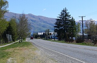
Hāwea Flat is a rural settlement in the Queenstown-Lakes District of the South Island of New Zealand. Lake Hāwea is 5 km north. The area was named for Hāwea-i-te-raki, an ancestor of the Ngāti Hāwea hapū. The macron was officially added to the place name in 2010. It is located to the east of State Highway 6 between Albert Town and Lake Hāwea.

<span class="mw-page-title-main">Taipa, Northland</span> Place in Northland Region, New Zealand

Taipa is a settlement on the southern side of Doubtless Bay in Northland, New Zealand. State Highway 10 runs through it. It is the westernmost of the Taipa-Mangonui string of settlements, and separated from the others by the Taipa River.

References

  1. 1 2 3 "ArcGIS Web Application". statsnz.maps.arcgis.com. Retrieved 31 December 2023.
  2. 1 2 "Subnational population estimates (RC, SA2), by age and sex, at 30 June 1996-2023 (2023 boundaries)". Statistics New Zealand . Retrieved 25 October 2023. (regional councils); "Subnational population estimates (TA, SA2), by age and sex, at 30 June 1996-2023 (2023 boundaries)". Statistics New Zealand . Retrieved 25 October 2023. (territorial authorities); "Subnational population estimates (urban rural), by age and sex, at 30 June 1996-2023 (2023 boundaries)". Statistics New Zealand . Retrieved 25 October 2023. (urban areas)
  3. 1 2 "Statistical area 1 dataset for 2018 Census". Statistics New Zealand. March 2020. 7029147–7029149.
  4. "Population estimate tables - NZ.Stat". Statistics New Zealand . Retrieved 25 October 2023.
  5. 1 2 "Statistical area 1 dataset for 2018 Census". Statistics New Zealand. March 2020. Riversdale-Piano Flat (358100). 2018 Census place summary: Riversdale-Piano Flat
  6. Exploring New Zealand's Ghost Railways, revised edition (Wellington: Grantham House, 1998 [1995]), 111-12.
  7. Education Counts: Riversdale School
  8. "New Zealand Schools Directory". New Zealand Ministry of Education. Retrieved 14 March 2024.
  9. "Riversdale School centennial, 1882-1982 (record)". National Library of New Zealand. Retrieved 29 January 2022.