
Southland District is a New Zealand territorial authority district that covers most of the southern end of the South Island as well as Stewart Island.

Lumsden is a town in Southland, New Zealand. Lying in a gap in the surrounding hills, Lumsden is the location of a major junction on State Highway 6. Lumsden is 81 kilometres north of Invercargill, 106 kilometres south of Queenstown, 59 kilometres west of Gore and 77 kilometres east of Te Anau.
Kingston is a small town at the southernmost end of Lake Wakatipu, just north of the border of Otago and Southland, in New Zealand's South Island. It is 47 kilometres south of Queenstown by a road, "The Devil's Staircase", which winds between the lake to the west and The Remarkables mountains to the east. It is 70 kilometres north of Lumsden, and close to the headwaters of the Mataura River.

Tuatapere is a small rural town in Southland, New Zealand. It is the self declared "Sausage Capital of New Zealand". Tuatapere is located eight kilometres from the southern coast. The Waiau River flows through the town before reaching Te Waewae Bay, where it has its outflow into Foveaux Strait. The main local industries are forestry and farming.

Rakaia is a town sited on the southern banks of the Rakaia River on the Canterbury Plains in New Zealand's South Island, approximately 57 km south of Christchurch on State Highway 1 and the Main South Line. Immediately north of the township are New Zealand's longest road bridge and longest rail bridge, both of which cross the wide shingle beds of the braided river at this point. Both bridges are approximately 1,750 metres (5,740 ft) in length.
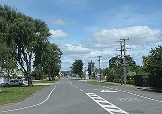
Wyndham is a rural town of 579 people in the South Island of New Zealand in the Southland region, 45 km (28 mi) east of Invercargill and 25 km (15 mi) south of Gore. The original Māori name of the locality was Mokoreta.

Mamaku is a small village in the Bay of Plenty Region of the North Island of New Zealand. It lies on the Mamaku Plateau at an elevation of 560 metres (1,840 ft) above sea level. Situated at the highest point of the now-mothballed Rotorua Branch railway line, the town is 4 kilometres (2.5 mi) south of State Highway 5.

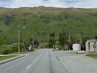
Mossburn is a small town in the northern Southland region of New Zealand. It is situated 113 km south of Queenstown, 59 km east of Te Anau and 100 km north of Invercargill.

Clinton is a small town in South Otago, in New Zealand's South Island. Handy to the Catlins, Dunedin, Lawrence, Central Otago and Tapanui. It is located on State Highway 1 approximately halfway between Balclutha and Gore, and the Main South Line railway passes through the town.

Waikari is a small town in the Canterbury region of New Zealand's South Island.
Hawarden is a small town in the Canterbury region of New Zealand's South Island. It is located near Waikari, just off State Highway 7.
Warrington, known in Māori as Ōkāhau, is a small settlement on the coast of Otago, in the South Island of New Zealand. It is situated close to the northern shore of Blueskin Bay, an area of mudflats north of Dunedin, and is administered as part of Dunedin City. Warrington is 3 km (1.9 mi) from State Highway 1 linked by Coast Road. The Main South Line railway passes through the township and a tourist train, the Seasider passes through the settlement once or twice a week between Dunedin and Palmerston.

Tāneatua is a small town in the Bay of Plenty region of New Zealand's North Island, 13 kilometres south of Whakatāne. State Highway 2 passes through the town on its route between Edgecumbe and Ōpōtiki. The small settlements of Ruatoki and Waimana are to the south and south-east of Tāneatua.
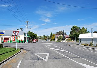
Edendale is a town in the Southland region of New Zealand's South Island. The township is situated on the Southland Plains just to the west of the Mataura River. Before the town was called Edendale, it was known by the names Maorirua, Mataura Plains and Stuart's Bush.
Wallacetown is a small town in Southland, in the South Island of New Zealand. Wallacetown is to the west of Invercargill, on high ground between the Makarewa and Ōreti rivers, near the Ōreti's estuary. Both rivers are popular for trout and whitebait fishing. It is considered to be a satellite town of Invercargill. It is served by State Highway 99, which skirts the town's northern edge.
Pukenui is a locality on the southwest side of Houhora Harbour on the Aupouri Peninsula of Northland, New Zealand. State Highway 1 runs through it. The name means "large hill" in the Māori language.

Kaipara Flats is a locality in the Rodney District of New Zealand. Warkworth is 12 km to the east, Ahuroa to the south, and Tauhoa to the north-west. The North Auckland railway line passes through the area.
Pareora is a small town in the South Island of New Zealand. It is located close to State Highway 1, which bypasses the western edge of the town, and close to the Pacific Ocean coast, five kilometres north of Saint Andrews and 10 kilometres south of Timaru. The Pareora River reaches the ocean just to the south of the township.

Ashley is a small town in North Canterbury, in the South Island of New Zealand. It used to have a railway station on the Main North Line that runs through the village.

Southland is New Zealand's southernmost region. It consists of the southwestern portion of the South Island and includes Stewart Island. Southland is bordered by the culturally similar Otago Region to the north and east, and the West Coast Region in the extreme northwest. The region covers over 3.1 million hectares and spans 3,613 km of coastline. As of June 2023, Southland has a population of 103,900, making it the eleventh-most-populous New Zealand region, and the second-most sparsely populated. Approximately half of the region's population lives in Invercargill, Southland's only city.
