Waikawa and Districts MuseumFormer Waikawa Church (now part of Museum)
The township is now a small fishing settlement, but at one time in the late 19th century was a major port, shipping timber from the sawmills of the Catlins north to help build the new town of Dunedin. Originally a small Māori community, the first European settlers to the area set up sawmills in the late 1830s.
Unfortunately for Waikawa, the port facilities were prone to silting, and the nearby township of Fortrose became the more prominent port. It too fell prey to the arrival of the Tokanui Branch railway, and to a lesser extent the Catlins River Branch, in the late 1890s.
Today Waikawa hosts a museum, community centre, a popular fish and chip wagon and numerous accommodations and holiday homes because of its close proximity to Curio Bay and Porpoise Bay. Parts of Catlins Conservation Park are located nearby.
The Waikawa Museum and Information Centre was formed from two old school buildings, one from the former Waikawa School, and is run by volunteers also offering information to tourists who visit the area.
Most of the township faces the Waikawa estuary. This estuary is home to flounder, or flatfish, which can be fished out of the water by trawling nets.
Riverton, officially Riverton / Aparima, is a small New Zealand town 30 kilometres (19 mi) west of Invercargill, on the south-eastern shorelines of the Jacobs River Estuary. The estuary is formed by the Aparima and Pourakino rivers, leading through a narrow outflow channel into Foveaux Strait. Accessible via State Highway 99 on the Southern Scenic Route, the main part of the town is on flat land and the northern end of Oreti Beach. South Riverton is built on the hills between the eastern shore of the estuary and Taramea Bay.
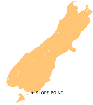
Slope Point is the southernmost point of the South Island of New Zealand.
Nickel Centre was a town in Ontario, Canada, which existed from 1973 to 2000.
Port Stephens, an open youthful tide-dominated drowned-valley estuary, is a large natural harbour of approximately 134 square kilometres (52 sq mi) located in the Hunter and Mid North Coast regions of New South Wales, Australia.
The Catlins comprise an area in the southeastern corner of the South Island of New Zealand. The area lies between Balclutha and Invercargill, straddling the boundary between the Otago and Southland regions. It includes the South Island's southernmost point, Slope Point.
Bala is a compact rural community in the township municipality of Muskoka Lakes, District Municipality of Muskoka in Central Ontario, Canada. It is well-known for the Bala Falls, the source of the Moon River, which flows from Lake Muskoka to the Georgian Bay.
The Ōwaka River, until 2019 officially the Owaka River, flows southeastward through The Catlins, an area of the southern South Island of New Zealand. Its total length is 30 kilometres (19 mi), and it shares the estuary of the Catlins River, flowing into the Pacific Ocean at Pounawea, 28 kilometres (17 mi) south of Balclutha. Its source is on the slopes of Mount Rosebery, 12 kilometres (7.5 mi) south of Clinton. The Ōwaka River is located within the Clutha District.
The Catlins River flows southeastward through The Catlins, an area of the southern South Island of New Zealand. Its total length is 42 kilometres (26 mi), and it flows into the Pacific Ocean at the holiday settlement of Pounawea, 28 kilometres (17 mi) south of Balclutha. Its upper estuary is called Catlins Lake, and its lower estuary is shared with the Ōwaka River. The lower estuary is also known at Pounawea Estuary.
The Tahakopa River flows southeastward through the Catlins, an area of the southern South Island of New Zealand. Its total length is 32 kilometres (20 mi), and it flows into the Pacific Ocean 30 kilometres (19 mi) east of Waikawa, close to the settlement of Papatowai. The Maclennan River is a tributary.
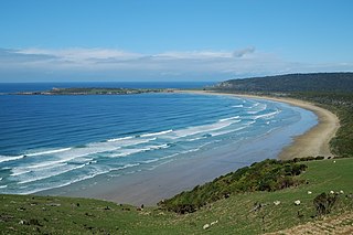
Curio Bay is a coastal embayment in the Southland District of New Zealand, best known as the site of a petrified forest some 180 million years old. It also hosts a yellow-eyed penguin colony, arguably the rarest of penguin species, with approximately 1600 breeding pairs in the extant population. The bay, along with neighbouring Porpoise Bay, is home to the endemic Hector's dolphin. Southern right whales are occasionally observed offshore, as on numerous parts of the country's coast. Located near the southernmost point of the South Island, Curio Bay is one of the major attractions in the Catlins, attracting around 100,000 visitors per year. The town of Waikawa has an information centre for tourists.
The Catlins Ranges are a series of rugged, roughly parallel hill ranges in the southeastern corner of New Zealand's South Island.
Jack's Bay is a small settlement in The Catlins, an area on the southeastern corner of the South Island of New Zealand. It is located six kilometres southwest of Owaka, close to the mouth of the Catlins River. A popular holiday spot with a seasonal population, there are numerous cribs at the settlement. Jack's Bay is noted for a large blowhole, known as Jack's Blowhole, a 55-metre-deep blowhole that formed when part of a sea cavern's roof collapsed. The blowhole is 200 metres from the sea.
Maclennan is a small settlement in The Catlins, an area of the southern South Island of New Zealand. It is located 20 kilometres southwest of Owaka. From 1915 until its closure on 27 February 1971, the Catlins River Branch railway passed through the village, and the station building and goods shed still stand today.
Glenomaru is a small settlement in The Catlins, an area of the southern South Island of New Zealand. It is located 10 kilometres north of Owaka on the main road to Balclutha. On 7 July 1891, a branch line railway from the Main South Line in Balclutha was opened to Glenomaru, and the village remained the terminus of the line until it was extended to Tahora on 16 December 1895. This line ultimately terminated in Tahakopa and was known as the Catlins River Branch. It closed on 27 February 1971 and a sawmill now exists on the site of Glenomaru station, though some of the railway's old formation can be seen in the surrounding area and the Hunts Road tunnel is in the vicinity and can be walked.
Tautuku Peninsula is a rocky headland in the Catlins on the south coast of Otago on the South Island of New Zealand. It is located 25 km (15 mi) east of Waikawa, at the western end of Tautuku Bay.
Tahakopa is a small settlement in The Catlins, an area of the southern South Island of New Zealand. It is located 25 kilometres northeast of Waikawa on the Tahakopa River. On 17 February 1915, Tahakopa became the terminus of the Catlins River Branch railway and retained this status until the branch line was closed on 27 February 1971. From the line's opening until 12 August 1956, a railway locomotive depot was based in the village. The old station building and goods shed still stand today.
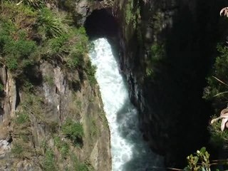
The Waikawa River flows east then south through the Catlins, an area of the southern South Island of New Zealand. Its total length is 23 kilometres (14 mi), and it flows into the Pacific Ocean at Waikawa. Close to its mouth, it cascades over a small series of cataracts, ironically named Niagara Falls.
Fortification is a locality in the western part of the Catlins region of Southland in New Zealand's South Island. Nearby settlements include Quarry Hills and Waikawa to the southeast, Tokanui to the southwest, and Waimahaka to the west. It is over 50 km east of Southland's main centre, Invercargill.
The small settlement of Caberfeidh is located in The Catlins, in the Otago region of New Zealand's South Island. The site of a former railway station on the Catlins Branch Line, it is sited close to a tributary of the Maclennan River, 5 kilometres north of the coast at Tahakopa Bay and 12 kilometres southwest of Owaka.
Port Molyneux is a tiny settlement on the coast of South Otago, New Zealand, close to the north-easternmost point of The Catlins. Now home only to farmland, it was a thriving port in the early years of New Zealand's European settlement.
This page is based on this Wikipedia article Text is available under the CC BY-SA 4.0 license; additional terms may apply. Images, videos and audio are available under their respective licenses.