Edendale, New Zealand

Last updated

Edendale
Edendale, New Zealand
Coordinates: 46°19′S168°47′E / 46.317°S 168.783°E / -46.317; 168.783
CountryNew Zealand
Region Southland region
Territorial authorities of New Zealand Southland District
WardWaihopai-Toetoe Ward
Community boardWaihopai-Toetoe Community
Electorates
Government
  Territorial authority Southland District Council
  Regional council Southland Regional Council
   Mayor of Southland Rob Scott
   Invercargill MP Penny Simmonds
   Te Tai Tonga MP Tākuta Ferris
Area
[1]
  Total2.92 km2 (1.13 sq mi)
Population
 (June 2023) [2]
  Total610
  Density210/km2 (540/sq mi)
Postcode(s)
9825
Area code 03

Edendale is a town in the Southland region of New Zealand's South Island. The township is situated on the Southland Plains just to the west of the Mataura River. Before the town was called Edendale, it was known by the names Maorirua, Mataura Plains and Stuart's Bush. [3]

Contents

History

Edendale was originally an estate of the New Zealand and Australian Land Company, who surveyed the township and sold it in lots. The estate contained over 120,000 acres. In the course of years the company sold 80,000 acres to hundreds of farmers. The New Zealand and Australian Land Company built the first large scale dairy factory in New Zealand in 1882, and secured a bonus of £500 from the government. [4] [5]

The homestead of the Edendale estate was bought in 1902 by its former manager, Mr Donald Macdonald. [6] Macdonald was instrumental in advocating the use of lime on the soils of Southland which vastly improved their quality. The Edendale Homestead is a Category I building listed by the Historic Places Trust. [7] Built circa 1882, the homestead is approach by a mile long drive through a beautiful and mature avenue of native trees, such as totara, black and white kahikatea and matai. [6] Descendants of Mr. Macdonald continue to own the property.

Demographics

Edendale is defined by Statistics New Zealand as a rural settlement. It covers 2.92 km2 (1.13 sq mi) and had an estimated population of 610 as of June 2023, [2] with a population density of 209 people per km2. It is part of the wider Edendale-Woodlands statistical area. [1]

Historical population for Edendale
YearPop.±% p.a.
2006516    
2013549+0.89%
2018591+1.49%
Source: [8]

Edendale had a population of 591 at the 2018 New Zealand census, an increase of 42 people (7.7%) since the 2013 census, and an increase of 75 people (14.5%) since the 2006 census. There were 243 households, comprising 312 males and 276 females, giving a sex ratio of 1.13 males per female, with 126 people (21.3%) aged under 15 years, 84 (14.2%) aged 15 to 29, 288 (48.7%) aged 30 to 64, and 90 (15.2%) aged 65 or older.

Ethnicities were 91.9% European/Pākehā, 13.7% Māori, 2.5% Pasifika, 2.5% Asian, and 1.0% other ethnicities. People may identify with more than one ethnicity.

Although some people chose not to answer the census's question about religious affiliation, 49.2% had no religion, and 43.7% were Christian.

Of those at least 15 years old, 48 (10.3%) people had a bachelor's or higher degree, and 126 (27.1%) people had no formal qualifications. 90 people (19.4%) earned over $70,000 compared to 17.2% nationally. The employment status of those at least 15 was that 258 (55.5%) people were employed full-time, 72 (15.5%) were part-time, and 12 (2.6%) were unemployed. [8]

Edendale-Woodlands

Edendale-Woodlands statistical area, which also includes Woodlands, covers 385.40 km2 (148.80 sq mi) [1] and had an estimated population of 2,420 as of June 2023, [9] with a population density of 6.3 people per km2.

Historical population for Edendale-Woodlands
YearPop.±% p.a.
20062,130    
20132,193+0.42%
20182,262+0.62%
Source: [10]

Edendale-Woodlands had a population of 2,262 at the 2018 New Zealand census, an increase of 69 people (3.1%) since the 2013 census, and an increase of 132 people (6.2%) since the 2006 census. There were 864 households, comprising 1,218 males and 1,044 females, giving a sex ratio of 1.17 males per female. The median age was 36.5 years (compared with 37.4 years nationally), with 519 people (22.9%) aged under 15 years, 387 (17.1%) aged 15 to 29, 1,098 (48.5%) aged 30 to 64, and 264 (11.7%) aged 65 or older.

Ethnicities were 86.2% European/Pākehā, 10.3% Māori, 1.6% Pasifika, 8.6% Asian, and 1.7% other ethnicities. People may identify with more than one ethnicity.

The percentage of people born overseas was 14.5, compared with 27.1% nationally.

Although some people chose not to answer the census's question about religious affiliation, 46.7% had no religion, 44.7% were Christian, 0.5% had Māori religious beliefs, 0.1% were Buddhist and 1.3% had other religions.

Of those at least 15 years old, 237 (13.6%) people had a bachelor's or higher degree, and 375 (21.5%) people had no formal qualifications. The median income was $41,500, compared with $31,800 nationally. 327 people (18.8%) earned over $70,000 compared to 17.2% nationally. The employment status of those at least 15 was that 1,089 (62.5%) people were employed full-time, 282 (16.2%) were part-time, and 51 (2.9%) were unemployed. [10]

Economy

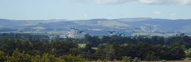
Edendale has a milk processing plant operated by Fonterra which was originally operated by the Southland Dairy Co-operative. The Edendale milk processing plant was a cheese processing plant but in the 1990s expanded to include milk powder processing. The plant has been expanded several times since and was in 2009 the largest raw milk processing plant in the world. [11]

The cheese plant ceased operations in late 2022, and in June 2023, Fonterra announced that the plant would be closed. [12]

EdendaleFonterra.jpg
Edendale as seen from a distance, the Fonterra dairy factory prominent.


In the main centre of Edendale, there are several small businesses and operations. These include a butcher, a dairy, a garage, a post office and a primary school.

Transport

State Highway 1 passes Edendale on its route between Gore and Invercargill. A 2.6 km (1.6 mi) bypass west of the dairy factory opened in December 2019, moving State Highway 1 out of the town itself. [13]

The Main South Line portion of the South Island Main Trunk Railway passes through Edendale, having served the town since April 1875. Although passenger services through the town ceased on 10 February 2002, Edendale had been served by some of New Zealand's premier passenger trains – first the South Express, then the South Island Limited, and finally the Southerner.

Edendale was a railway junction for almost eighty years. On 2 October 1882, a branch line from the South Island Main Trunk, the Wyndham Branch, was opened from Edendale to Wyndham on the opposite side of the Mataura River. On 1 May 1890, this line was extended to Glenham. Traffic was light from the beginning, with the extension to Glenham closed on 14 July 1930 and passenger services to Edendale – originally provided by mixed trains and then by RM class Model T Ford railcars – were cancelled on 9 February 1931. By the late 1950s, the line to Wyndham was essentially just an extension of the Edendale railway yard and insufficient quantities of freight meant that the line was closed just weeks before its eightieth anniversary and Edendale ceased to be a railway junction on 9 September 1962.

Education

Edendale School is a state primary school with 116 students from Years 1 to 6 (ages 5 to 11). [14] . It opened in 1909 with a roll of 146 students and a capacity for up to 250 students. [15]

The nearest intermediate and secondary school is Menzies College, 5 km (3 mi) east of the town in Wyndham.

Related Research Articles

<span class="mw-page-title-main">Taranaki</span> Region of New Zealand

Taranaki is a region in the west of New Zealand's North Island. It is named after its main geographical feature, the stratovolcano Mount Taranaki, also known as Mount Egmont.

<span class="mw-page-title-main">West Coast Region</span> Region of New Zealand

The West Coast is a region of New Zealand on the west coast of the South Island. It is administered by the West Coast Regional Council, and is known co-officially as Te Tai Poutini. It comprises the territorial authorities of Buller District, Grey District and Westland District. The principal towns are Westport, Greymouth and Hokitika. The region, one of the more remote areas of the country, is also the most sparsely populated. With a population of just 32,900 people, the West Coast is the least populous region in New Zealand. The population in the region grew by 0.4% over the year to July 2023.

<span class="mw-page-title-main">Gore, New Zealand</span> Town in Southland region, New Zealand

Gore is a town and district in the Southland region of the South Island of New Zealand. It has a resident population of 8,240 as of June 2023. Gore is known for its country music scene and hosts an annual country music festival. The town is also surrounded by farmland and is an important centre for agriculture in the region.

<span class="mw-page-title-main">Darfield, New Zealand</span> Town in Canterbury, New Zealand

Darfield is a town in the Selwyn District of the South Island of New Zealand. It is 35 kilometres west of Christchurch. Its population is 3,150 as of June 2023.

Mataura is a town in the Southland region of the South Island of New Zealand. Mataura has a meat processing plant, and until 2000 it was the site of a large pulp and paper mill.

<span class="mw-page-title-main">Waipā District</span> Territorial authority district in Waikato, New Zealand

Waipa District is a municipality in the Waikato region of New Zealand that is administered by the Waipa District Council. Its most populous town is Cambridge. The seat of the council is at the second most populous town, Te Awamutu. The district is south and south-east of the city of Hamilton. It has five wards: Te Awamutu, Cambridge, Pirongia, Maungatautari and Kakepuku.

<span class="mw-page-title-main">Southland District</span> Territorial authority district in Southland Region, New Zealand

Southland District is a New Zealand territorial authority district that covers most of the southern end of the South Island as well as Stewart Island.

<span class="mw-page-title-main">Kingston, New Zealand</span> Rural settlement in Otago, New Zealand

Kingston is a small town at the southernmost end of Lake Wakatipu, just north of the border of Otago and Southland, in New Zealand's South Island. It is 47 kilometres south of Queenstown by a road, "The Devil's Staircase", which winds between the lake to the west and The Remarkables mountains to the east. It is 70 kilometres north of Lumsden, and close to the headwaters of the Mataura River.

<span class="mw-page-title-main">Granity</span> Town on the West Coast of the South Island of New Zealand

Granity is a small town on the West Coast of New Zealand's South Island, 28 kilometres (17 mi) north-east of Westport on State Highway 67. Karamea is 68 kilometres (42 mi) further north.

<span class="mw-page-title-main">Tākaka</span> Town in Golden Bay, New Zealand

Tākaka is a small town situated at the southeastern end of Golden Bay, at the northern end of New Zealand's South Island, located on the lower reaches of the Tākaka River. State Highway 60 runs through Takaka and follows the river valley before climbing over Tākaka Hill, to Motueka linking Golden Bay with the more populated coast of Tasman Bay to the southeast. The town is served by Tākaka Aerodrome.

<span class="mw-page-title-main">Wyndham, New Zealand</span> Town in Southland region, New Zealand

Wyndham is a rural town of 579 people in the South Island of New Zealand in the Southland region, 45 km (28 mi) east of Invercargill and 25 km (15 mi) south of Gore. The original Māori name of the locality was Mokoreta.

Balfour is a small town located in the Southland region of New Zealand.

Woodlands is a small town in the Southland region of New Zealand's South Island on the banks of the Waihopai River. It is northeast of Invercargill between Dacre and Longbush. Other nearby settlements are Rakahouka to the northwest and Rimu and Waituna to the south.

Longburn is a rural settlement just outside Palmerston North in the Manawatū-Whanganui area of New Zealand. Made up of large dairy processing plants Longburn is often mistaken to be a small township and not seen as a large satellite town of Palmerston North. The township is home to both Longburn School and Longburn Adventist College.

Waitoa is a settlement in the Matamata-Piako District of New Zealand. State Highway 26 runs through the town, and connects to Te Aroha 10 km to the north-east.

<span class="mw-page-title-main">Gore District, New Zealand</span> Territorial authority district in Southland, New Zealand

Gore District is a district in the Southland Region of the South Island of New Zealand. It is named for Gore, the district's biggest township.

Riversdale is a small town in the Southland region of New Zealand.

Waikaia, formerly known as Switzers, is a town in the Southland region of New Zealand's South Island. From 1909 until 1959, it was the terminus of the Waikaia Branch railway. The population in the 2013 census was 99, unchanged from the previous census in 2006.

<span class="mw-page-title-main">Southland Region</span> Region of New Zealand

Southland is New Zealand's southernmost region. It consists of the southwestern portion of the South Island and includes Stewart Island. Southland is bordered by the culturally similar Otago Region to the north and east, and the West Coast Region in the extreme northwest. The region covers over 3.1 million hectares and spans 3,613 km of coastline. As of June 2023, Southland has a population of 103,900, making it the eleventh-most-populous New Zealand region, and the second-most sparsely populated. Approximately half of the region's population lives in Invercargill, Southland's only city.

Menzies Ferry is a farming locality on the west side of the Mataura River in the east of Southland District, in the south of New Zealand. It gained its name from Dr. James Alexander Robertson Menzies, who supplied a boat to ferry passengers across the Mataura. It was surveyed as a township in 1876.

References

  1. 1 2 3 "ArcGIS Web Application". statsnz.maps.arcgis.com. Retrieved 15 January 2021.
  2. 1 2 "Subnational population estimates (RC, SA2), by age and sex, at 30 June 1996-2023 (2023 boundaries)". Statistics New Zealand . Retrieved 25 October 2023. (regional councils); "Subnational population estimates (TA, SA2), by age and sex, at 30 June 1996-2023 (2023 boundaries)". Statistics New Zealand . Retrieved 25 October 2023. (territorial authorities); "Subnational population estimates (urban rural), by age and sex, at 30 June 1996-2023 (2023 boundaries)". Statistics New Zealand . Retrieved 25 October 2023. (urban areas)
  3. Beattie, H. (2 September 1912). "Place Names – Southern Region". The Mataura Ensign. Retrieved 3 January 2017 via Papers Past.
  4. "The New Zealand And Australian Land Company, Ltd | NZETC". nzetc.victoria.ac.nz. Retrieved 17 October 2021.
  5. "Land company's story told". Otago Daily Times Online News. 22 August 2018. Retrieved 17 October 2021.
  6. 1 2 "Edendale Homestead | NZETC". nzetc.victoria.ac.nz. Retrieved 17 October 2021.
  7. Southland District Council (2016). "Archaeological Assessment: Edendale SH1 Realignment Project" (PDF). Archived (PDF) from the original on 20 April 2017.
  8. 1 2 "Statistical area 1 dataset for 2018 Census". Statistics New Zealand. March 2020. 7029320–7029323).
  9. "Population estimate tables - NZ.Stat". Statistics New Zealand . Retrieved 25 October 2023.
  10. 1 2 "Statistical area 1 dataset for 2018 Census". Statistics New Zealand. March 2020. Edendale-Woodlands (359100). 2018 Census place summary: Edendale-Woodlands
  11. Hotton, Mike (26 September 2009). "New milk dryer makes Edendale processor 'world's biggest'". The Southland Times . Retrieved 4 October 2009.
  12. Harding, Evan (9 June 2023). "Fonterra: 34 jobs impacted by Edendale cheese plant closure". Stuff. Retrieved 4 July 2023.
  13. Palmer, Abbey (13 December 2019). "Ahead of time and on budget: SH1 realignment completed". Otago Daily Times Online News. Retrieved 10 February 2021.
  14. "New Zealand Schools Directory". New Zealand Ministry of Education. Retrieved 14 March 2024.
  15. "School History". edendale.school.nz. Edendale Primary School.

Further reading