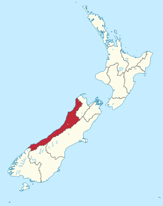
Ohai

Last updated
Ohai
Ohai.JPG
The main street in Ohai running parallel with the Ohai Line
New Zealand location map.svg
Disc Plain red.svg
Ohai
Coordinates: 45°55′59″S167°57′21″E / 45.93306°S 167.95583°E / -45.93306; 167.95583 Coordinates: 45°55′59″S167°57′21″E / 45.93306°S 167.95583°E / -45.93306; 167.95583
Country New Zealand
Region Southland
District Southland District
Population
 (2013)
  Total303
View of the Takitimu Mountains from the main road of the town of Ohai View from Ohai.jpg
View of the Takitimu Mountains from the main road of the town of Ohai

Ohai is a town in the Southland region of New Zealand's South Island, 65 kilometres northwest of Invercargill and 25 kilometres west of Winton. The 2013 New Zealand census gave its population as 303, a decline of 54 people since the 2006 census. [1] [2]

Contents

History

Origins of name

The literal meaning of Ohai is unclear, but a mural in the town centre reads "OHAI" and then curved underneath "Place of the Stone". The name Ohai was recorded by James Herries Beattie as in use for the area before 1840. [3] Up until as late as 1958 Morley stream near the town was officially called Ohai Stream in the Wairio District Survey maps. [4] [5] It is likely that the area was originally named in relation to an historic Maori stone quarry that is nearby as described in New Zealand Archaeological Association Schedule & Maps of Recorded Archaeological Sites, Map 7, Page 271 [6]

Early history

Ohai township was founded in 1917 following the discovery of large amounts of high quality coal in the area. However, the early days of mining were restricted by poor roads. Coal production boomed in the area in 1925, when the Ohai Railway Board opened a new line linking Wairio to the Ohai Railway District. This line also carried workers between Wairio and Ohai on a passenger steam train called the ‘Piecart’.[ citation needed ]

In order to provide convenient transport of the coal to markets beyond the local area, a privately owned railway extension from the New Zealand Railways Department's Wairio Branch was opened by the Ohai Railway Board in January 1925. In 1934, this line was further extended beyond Ohai to Birchwood, but the terminus had reverted to Ohai by the time the line was incorporated into the national rail network in 1990. The line is now called the Ohai Line and is one of the very few survivors of a formerly extensive rural branch line network. The Ohai Railway Board Heritage Trust, which had no connection with the Ohai Railway Board, was involved in the restoration of steam locomotives including members of the P and V classes and a railway museum was established, but the trust has been dissolved.[ citation needed ]

Modern history

Mechanization of mining methods in the 1980s brought huge changes to Ohai (and the nearby sister town of Nightcaps). Many families with generations associated in mining left the area. In Ohai today, shearing now rivals mining as the biggest industry employer in the town. Recent times have seen a number of people move into the Ohai/Nightcaps area (many of them North Islanders), attracted by the rural lifestyle and affordable housing. Ohai's rural location lends itself well to many outdoor pursuits. These include fishing and duck hunting, the close proximity of rivers and duck ponds making these popular local pursuits. [7]

The Ohai coal mine closed in September 2021 [8]

Infrastructure

Ohai is the terminus of State Highway 96, which runs from Mataura via Hedgehope and Winton. The primary school closed in 2003 and students now attend school in nearby Nightcaps. A heated and covered swimming pool, tennis courts, golf course, a bowls club, a police station, and a recreational reserve are located in the town.

The Takitimu District Pool is a large (33 metre) heated, covered pool in Ohai. It is open for use during daylight hours from around late October through to March. Sliding doors allow the pool area to be opened out to an outdoor garden. Public sessions are available at certain times most afternoons during the season. Once a week during these sessions the 'inflatable' is used in the pool. Alternatively, family or single keys can be purchased seasonally, providing users with unlimited use during daylight hours. Local coal, supplied by Solid Energy, heats the swimming pool. Many volunteers donate their time to help maintain and manage this facility. [9]

Despite concerns about the closure of the mine, many residents look forward to the establishment of recreational lakes that will be connected to the local trout stream, and the construction of walkways around the Morley streams and proposed lakes. An example of the coal mine rehabilitation with the similar community use concept can be found at Glyncorrwg, South Wales, United Kingdom. [10] [11]

Major petroleum company L&M Energy is successfully completing the final stages of its well-drilling programme for coal seam gas production on the outskirts of the town. If the Ohai coal seam gas project is able to convert its existing 3P gas reserves into 2P reserves for development, it could be the biggest onshore gas project in New Zealand, creating growth and opportunities in this town.

Threat of mine subsidence

Map showing extent of underground mining in Ohai area. Image of mining under Ohai area.jpg
Map showing extent of underground mining in Ohai area.

During 2012 there was some concern from some residents of a possible mine subsidence risk in Ohai, due to several old mining tunnels under the Northern part of the township dating from pre-World War II, the old Wairaki 3 mine works.

In July, a man had called the council claiming his drainage system was affected by subsidence, but an engineer had concluded it was not the case. [12] Solid Energy had told the council the risk of subsidence from the old Wairaki 3 mine works, which lie under the northern side of the township, was "very minimal", he said, since subsidence normally occurred in the first few years, but they would continue working together to examine it.

After an unrelated survey of 2 km of pipes was completed, Council Chief executive Dave Adamson said overall, the survey work did not highlight any areas that may cause significant immediate concern. "Now that we have some good information on the condition of the pipes it will allow us to plan better for the long term. It needs to be made clear the purpose of the survey was to determine the condition and remaining life of the pipes, it was not to prove or disprove the existence of a subsidence issue or problem." "However, any subsidence would have been obvious during the camera survey", Mr Adamson said.

Ohai CDA chairman John Hogg said he had not heard of houses or gardens subsiding in the township. Council chief executive Dave Adamson said he had asked staff to look at the problem, but many old mining towns in New Zealand had tunnels underneath them. "As far as I know we haven't had any direct reports of subsidence issues to date," he said. However, going public with the potential subsidence issue was not welcomed by some in Ohai. One of the CDA members who resigned, said he was unhappy another CDA member had gone to the Southland Times,(Regional Newspaper). [13] [14]

Related Research Articles

Huntly, New Zealand Minor urban area in Waikato, New Zealand

Huntly is a town in the Waikato district and region of the North Island of New Zealand. It is on State Highway 1, 95 kilometres (59 mi) south of Auckland and 32 kilometres (20 mi) north of Hamilton. It is situated on the North Island Main Trunk (NIMT) railway and straddles the Waikato River. Huntly is within the Waikato District which is in the northern part of the Waikato region local government area.

Kaitangata, New Zealand Place in Otago, New Zealand

Kaitangata is a town near the coast of South Otago, New Zealand, on the left bank of the Clutha River ten kilometres south east of Balclutha. The town is known to its residents simply as Kai.

Winton, New Zealand Town in Southland, New Zealand

Winton is a rural town in Southland, New Zealand. It is located close to the east bank of the Oreti River, 30 kilometres north of Invercargill and 50 kilometres south of Lumsden. The town is named after Thomas Winton, a local stockman who lived and farmed in the area in the 1850s. Winton has a population of 2,211 as of the 2013 Census. The district thrived with the development of sheep and fat-lamb farms in the early 1900s. Later, dairy farming became the staple economy, although the town has also seen sawmills, and flax and linen-flax industries.
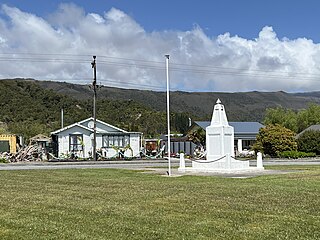
Longwall mining

Longwall mining is a form of underground coal mining where a long wall of coal is mined in a single slice. The longwall panel is typically 3–4 km (1.9–2.5 mi) long and 250–400 m (820–1,310 ft) wide.

Locomotives of New Zealand is a complete list of all locomotive classes that operate or have operated in New Zealand's railway network. It does not include locomotives used on bush tramways.

The Tuatapere Branch, including the Orawia Branch, was a branch line railway in Southland, New Zealand. Although the Tuatapere and Orawia Branches look like a single line, operationally they were considered separate lines. The first section opened to Riverton in 1879 and reached Tuatapere three decades later. The extension from Tuatapere to Orawia operated from 1925 until 1970. In 1976 the Tuatapere Branch was truncated to Riverton, and was known as the Riverton Branch until 1978, when it closed beyond Thornbury. The remaining portion of the line is now part of the Wairio Branch.

The Ohai Line, formerly known as the Ohai Industrial Line and previously the Wairio Branch and the Ohai Railway Board's line, is a 54.5 km branch line railway in Southland, New Zealand. It opened in 1882 and is one of two remaining branch lines in Southland, and one of only a few in the country. A number of smaller privately owned railways fanned out from Wairio; one of these lines, to Ohai, was originally built by the Ohai Railway Board and was worked by New Zealand Railways from 1990 and incorporated into the national network in 1992.

Orepuki Locality in Southland District, Southland Region, New Zealand

Orepuki in Southland, New Zealand is a small country township on the coast of Te Waewae Bay some 20 minutes from Riverton, 15 minutes from Tuatapere and 50 minutes from Invercargill that sits at the foot of the Longwood Range. Once a thriving gold mining settlement of 3000 people, today Orepuki is something of a ghost town with an assortment of abandoned stores, goldmining relics and sluicing scars as the only reminders of its former glory.

Solid Energy was the largest coal mining company in New Zealand and is a state owned enterprise of the New Zealand Government.

Brymbo Human settlement in Wales

Brymbo is a large village and local government community, the lowest tier of local government, in Wrexham County Borough, Wales. It lies in the hilly country to the west of Wrexham town, largely surrounded by farmland.

Nightcaps, New Zealand Place in Southland, New Zealand

Nightcaps is a town in the Southland region of New Zealand's South Island. According to the 2013 New Zealand census, its population is 294, consisting of 165 males and 132 females. This represents a decline of 15 people since the 2006 census. State Highway 96 passes through Nightcaps as it runs between Ohai and Winton. The town has a golf course and two primary schools that cater to students from Nightcaps, the surrounding rural area, and since the 2003 closure of its own school, Ohai.

Birchwood, New Zealand Locality in New Zealand

Birchwood is a locality in the Southland region of New Zealand's South Island. It is situated west of Ohai and Nightcaps, and north of Tuatapere and Orawia, with the nearest state highway in Ohai.

Thornbury is a small township on the east bank of the lower Aparima River, in western Southland, New Zealand. It is approximately 10 km northeast of Riverton, and 31 km northwest of Invercargill. It is mainly a farming service community. Local small industries include machinery and transport/trucking companies, and a tannery.

Mining in New Zealand

Mining in New Zealand began when the Māori quarried rock such as argillite in times prior to European colonisation. Mining by Europeans began in the latter half of the 19th century.

State Highway 99 (New Zealand) Road in New Zealand

State Highway 99 is a New Zealand state highway which runs along the southern coastline of the South Island connecting the settlements of Clifden and Lorneville, near Invercargill, via the major town of Riverton in the Southland region. The road is important both as a freight route, especially for logging and agricultural purposes, and as a tourist route; the entire length of the highway is part of the Southern Scenic Route as it provides access to southern parts of Fiordland National Park.

Southland, New Zealand Region of New Zealand

Southland is New Zealand's southernmost region. It consists mainly of the southwestern portion of the South Island and Stewart Island/Rakiura. It includes Southland District, Gore District and the city of Invercargill. The region covers over 3.1 million hectares and spans over 3,400 km of coast.

Branxholme locomotive dump

Branxholme locomotive dump is a steam locomotive and wagon dump located on the eastern bank of the Oreti River adjacent and just to the north of Southland's Wairio Branch Line in New Zealand. Locomotives and rolling stock have been dumped here for river protection since the 1920s. In the time since numerous items have been recovered for preservation purposes.

The Ohai Railway Board (ORB) was a short railway in Southland, New Zealand. The railway line itself still exists as the Ohai branch line, but the ORB was dissolved in 1990, and in 1992 the Southland District Council sold the board's assets to New Zealand Rail Limited.

In the mid-19th century, Colorado Springs was a center of mining industry activity. Coal was mined in 50 mines in the area and towns, now annexed to Colorado Springs, were established to support residents of the coal mining industry.

Bathurst Resources, along with a number of subsidiaries, is a coal mining company in New Zealand that was established in 2010.

References

  1. 2013 Census QuickStats about a place  : Ohai
  2. Wright, Petrina. "Affordable housing a boon for Ohai".
  3. "GLOBAL – Full Display – Record 1 of 1". Tapuhi.natlib.govt.nz. Archived from the original on 2012-07-14. Retrieved 2012-09-19.
  4. "Wairio survey district 1958 | Items | National Library of New Zealand – National Library of New Zealand". Beta.natlib.govt.nz. Archived from the original on 2013-02-23. Retrieved 2012-09-19.
  5. "Resource Community Formation & Change : A Case Study of OHAI" (PDF). Tba.co.nz. Retrieved 2017-08-22.
  6. "Archived copy" (PDF). Archived from the original (PDF) on 2013-02-09. Retrieved 2012-01-20.CS1 maint: archived copy as title (link)
  7. "Ohai". Western Southland. Retrieved 2012-09-19.
  8. "'End of an era': Ohai locals recall life, friendships in a once bustling mining town". RNZ. 2021-09-30. Retrieved 2021-10-03.
  9. "Takitimu District Pool". Western Southland. Retrieved 2012-09-19.
  10. "Archived copy" (PDF). Archived from the original (PDF) on 2010-05-22. Retrieved 2012-01-20.CS1 maint: archived copy as title (link)
  11. "Solid Energy confirms Ohai Mine closure". Scoop.co.nz. 2009-02-19. Retrieved 2012-09-19.
  12. "Subsidence allegations alarm residents". Stuff. Retrieved 22 August 2017.
  13. "Meeting mooted to allay concerns". Stuff. Retrieved 22 August 2017.
  14. "Disused tunnels' risks still on agenda". Stuff. Retrieved 22 August 2017.