Otago is a region of New Zealand located in the southern half of the South Island administered by the Otago Regional Council. It has an area of approximately 32,000 square kilometres (12,000 sq mi), making it the country's second largest local government region. Its population was 254,600 in June 2023.

Invercargill is the southernmost and westernmost city in New Zealand, and one of the southernmost cities in the world. It is the commercial centre of the Southland region. The city lies in the heart of the wide expanse of the Southland Plains to the east of the Ōreti or New River some 18 km north of Bluff, which is the southernmost town in the South Island. It sits amid rich farmland that is bordered by large areas of conservation land and marine reserves, including Fiordland National Park covering the south-west corner of the South Island and the Catlins coastal region.
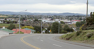
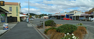
Balclutha is a town in South Otago, lying towards the end of the Clutha River, on the east coast of the South Island of New Zealand. It is about halfway between Dunedin and Gore on the Main South Line railway, State Highway 1 and the Southern Scenic Route. Balclutha has a population of 4,340, and is the largest town in South Otago.
Kaitangata is a town near the coast of South Otago, New Zealand, on the left bank of the Matau Branch of the Clutha River ten kilometres south east of Balclutha. The town is known to its residents simply as Kai.
Winton is a rural town in Southland, New Zealand. It is located close to the east bank of the Ōreti River, 30 kilometres north of Invercargill and 50 kilometres south of Lumsden. The town is named after Thomas Winton, a local stockman who lived and farmed in the area in the 1850s. The district thrived with the development of sheep and fat-lamb farms in the early 1900s. Later, dairy farming became the staple economy, although the town has also seen sawmills, and flax and linen-flax industries.

Southland District is a New Zealand territorial authority district that covers most of the southern end of the South Island as well as Stewart Island.

The Catlins comprise an area in the southeastern corner of the South Island of New Zealand. The area lies between Balclutha and Invercargill, straddling the boundary between the Otago and Southland regions. It includes the South Island's southernmost point, Slope Point.
Roxburgh is a small New Zealand town of about 600 people in Central Otago. It is in Teviot Valley on the banks of the Clutha River, 40 kilometres (25 mi) south of Alexandra in the South Island. State Highway 8, which links Central Otago with Dunedin city, passes through the town. Roxburgh is well known for its Summer fruit and "Jimmy's Pies."

Lumsden is a town in Southland, New Zealand. Lying in a gap in the surrounding hills, Lumsden is the location of a major junction on State Highway 6. Lumsden is 81 kilometres north of Invercargill, 106 kilometres south of Queenstown, 59 kilometres west of Gore and 77 kilometres east of Te Anau.

The Awarua Plain is a large area of wetland to the east of Bluff, New Zealand. Covering an area of around 600 km², the plain stretches for 35 kilometres along the coast of Foveaux Strait. This stretch of coast includes the peninsula of Tiwai Point, Awarua Bay, the Waituna Lagoon, and Toetoes Bay. The Mataura River is the major river responsible for the presence of the Awarua Plain; along with the Ōreti River, it is a remnant of the rivers from the Ice Ages that formed the Southland Plains (Murihiku). In addition, several small streams enter Foveaux Strait along this stretch of coast, mainly via Awarua Bay and Waituna Lagoon.

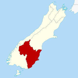
Clutha District is a local government district of southern New Zealand, with its headquarters in the Otago town of Balclutha. Clutha District has a land area of 6,334.47 km2 (2,445.75 sq mi) and an estimated population of 18,900 as of June 2023. Clutha District occupies the majority of the geographical area known as South Otago.

Mossburn is a small town in the northern Southland region of New Zealand. It is situated 113 km south of Queenstown, 59 km east of Te Anau and 100 km north of Invercargill.
Balfour is a small town located in the Southland region of New Zealand.
Wallacetown is a small town in Southland, in the South Island of New Zealand. Wallacetown is to the west of Invercargill, on high ground between the Makarewa and Ōreti rivers, near the Ōreti's estuary. Both rivers are popular for trout and whitebait fishing. It is considered to be a satellite town of Invercargill. It is served by State Highway 99, which skirts the town's northern edge.

Luggate is a small town in the South Island of New Zealand. It is located on State Highway 6 between Wānaka and Cromwell, near the junction with State Highway 8A, approximately 15 km from the Wānaka township, just past Wānaka Airport.
Stirling is a settlement in New Zealand. It is located in South Otago, approximately 5 km from Balclutha, and just north of the Matau Branch of the Clutha River.
Riversdale is a small town in the Southland region of New Zealand.
Otatara is an outer suburb of New Zealand's southernmost city, Invercargill. It is surrounded by the Ōreti River to the west and south, and its estuary and Invercargill Airport to the east, and West Plains to the north. Historically, it was in Southland County before it was abolished.
Clydevale is a township on the banks of the Clutha River / Mata-Au, in the Clutha Valley, 29 kilometres north-west of Balclutha.
West Plains is a locality in the Southland Region of New Zealand, northwest of Invercargill and north of Otatara. Ōreti River and its tributary Makarewa River flow through the plains. It is part of the Southland Plains.
