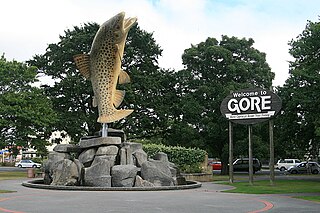
Gore is a town and district in the Southland region of the South Island of New Zealand. It has a resident population of 8,240 as of June 2023. Gore is known for its country music scene and hosts an annual country music festival. The town is also surrounded by farmland and is an important centre for agriculture in the region.

Invercargill is the southernmost and westernmost city in New Zealand, and one of the southernmost cities in the world. It is the commercial centre of the Southland region. The city lies in the heart of the wide expanse of the Southland Plains to the east of the Ōreti or New River some 18 km north of Bluff, which is the southernmost town in the South Island. It sits amid rich farmland that is bordered by large areas of conservation land and marine reserves, including Fiordland National Park covering the south-west corner of the South Island and the Catlins coastal region.

Fiordland is a geographical region of New Zealand in the south-western corner of the South Island, comprising the westernmost third of Southland. Most of Fiordland is dominated by the steep sides of the snow-capped Southern Alps, deep lakes, and its steep, glacier-carved and now ocean-flooded western valleys. The name "Fiordland" comes from a variant spelling of the Scandinavian word for this type of steep valley, "fjord". The area of Fiordland is dominated by, and very roughly coterminous with, Fiordland National Park, New Zealand's largest National Park.

Alexandra is a town in the Central Otago district of the South Island of New Zealand. It is on the banks of the Clutha River, on State Highway 8, 188 kilometres (117 mi) by road from Dunedin and 33 kilometres (21 mi) south of Cromwell. The nearest towns to Alexandra via state highway 8 are Clyde seven kilometres to the northwest and Roxburgh forty kilometres to the south. State highway 85 also connects Alexandra to Omakau, Lauder, Oturehua, Ranfurly and on to Palmerston on the East Otago coast.

Fiordland National Park is a national park in the south-west corner of South Island of New Zealand. It is the largest of the 13 national parks in New Zealand, with an area covering 12,607 km2 (4,868 sq mi), and a major part of the Te Wāhipounamu a UNESCO World Heritage Site established in 1990. The park is administered by the Department of Conservation. The southern ranges of the Southern Alps cover most of Fiordland National Park, combined with the deep glacier-carved valleys.

Te Anau is a town in the Southland region of the South Island of New Zealand. In Māori, Te-Anau means the Place of the Swirling Waters. It is on the eastern shore of Lake Te Anau in Fiordland. Te Anau is 155 kilometres north of Invercargill and 171 kilometres to the southwest of Queenstown. Manapouri lies 21 kilometres to the south. Te Anau lies at the southern end of the Milford Road, 117 kilometres to the south of Milford Sound.

Waitomo is a rural community in the King Country region of New Zealand's North Island. There are several solutional cave systems in the area around the village, which are popular tourist attractions. Restaurants and accommodation are centred in the village to serve visiting tourists.

The Catlins comprise an area in the southeastern corner of the South Island of New Zealand. The area lies between Balclutha and Invercargill, straddling the boundary between the Otago and Southland regions. It includes the South Island's southernmost point, Slope Point.

Tuatapere is a small rural town in Southland, New Zealand. It is the self declared "Sausage Capital of New Zealand". Tuatapere is located eight kilometres from the southern coast. The Waiau River flows through the town before reaching Te Waewae Bay, where it has its outflow into Foveaux Strait. The main local industries are forestry and farming.

Lake Hauroko is the deepest lake in New Zealand. The lake, which is 462 metres deep, is located in a mountain valley in Fiordland National Park.

Tākaka is a small town situated at the southeastern end of Golden Bay, at the northern end of New Zealand's South Island, located on the lower reaches of the Tākaka River. State Highway 60 runs through Takaka and follows the river valley before climbing over Tākaka Hill, to Motueka linking Golden Bay with the more populated coast of Tasman Bay to the southeast. The town is served by Tākaka Aerodrome.

Ngātīmoti or Ngatimoti is a town near Motueka in New Zealand's South Island.
Nightcaps is a town in the Southland region of New Zealand's South Island. It is suggested that Nightcaps got its name either from the snow that is often seen on the Takitimu Mountains, or when early settlers observed fog on the hills known as the Nobbles. State Highway 96 passes through Nightcaps as it runs between Ohai and Winton. The town has a golf course and two primary schools that cater to students from Nightcaps, the surrounding rural area, and since the 2003 closure of its own school, Ohai.
Gorge Road is a locality in the Southland region of New Zealand's South Island. It is on the Southern Scenic Route and is situated on the western bank of the Mataura River. Nearby settlements include Ashers to the west, and across the Mataura, Pine Bush and Titiroa to the east.

The Clifden Suspension Bridge is a historic suspension bridge near Clifden, New Zealand with a single lane. Built in 1899, it spans the Waiau River and is 111.5 m long.

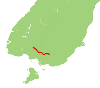
State Highway 96 is a New Zealand state highway connecting the Southland communities of Mataura, Winton, and Ohai. Starting at State Highway 1 the highway is 92 kilometres (57 mi) in length and runs in a general east–west direction. In Winton State Highway 96 runs concurrently with State Highway 6 for 1.6 kilometres (0.99 mi) kilometres.

Waikiwi is a suburb of Invercargill, Southland, New Zealand. Invercargill is the southernmost city of New Zealand.
Rangiotu is a farming community in the Manawatū District and Manawatū-Whanganui region in New Zealand's central North Island.
Clydevale is a township on the banks of the Clutha River / Mata-Au, in the Clutha Valley, 29 kilometres north-west of Balclutha.


