Related Research Articles
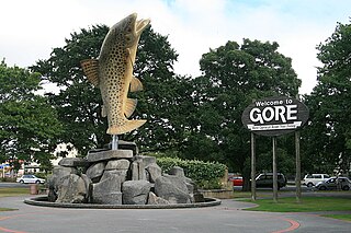
Gore is a town and district in the Southland region of the South Island of New Zealand. It has a resident population of 8,240 as of June 2023. Gore is known for its country music scene and hosts an annual country music festival. The town is also surrounded by farmland and is an important centre for agriculture in the region.
Mataura is a town in the Southland region of the South Island of New Zealand. Mataura has a meat processing plant, and until 2000 it was the site of a large pulp and paper mill.
The Southland Plains is a general name given to several areas of low-lying land in the South Island of New Zealand, separated by the rise of the Hokonui Hills in the north. It forms a sizeable area of Southland region and encompasses its two principal settlements the city of Invercargill and the town of Gore. The Southland Plains include some of New Zealand's most fertile farmland.

Toetoes Bay is the easternmost of three large bays lying on the Foveaux Strait coast of Southland, New Zealand, the others being Te Waewae Bay and Oreti Beach. The 240 km Mataura River drains to sea at Toetoes Bay, first passing through the Toetoes Harbour estuary. Thirty kilometres in length, the bay is the southern end of the Awarua Plain, an area of swampy land stretching inland for about fifteen kilometres. The eastern end of the bay is close to Slope Point, the South Island's southernmost point, and the western end of the Catlins.

The Southland Province was a province of New Zealand from March 1861, when it split from Otago Province, until 1870, when it rejoined Otago.

Dacre is a small town in the South Island of New Zealand. It is situated on the Southland Plains between Invercargill and Edendale on State Highway 1. In Dacre, SH 1 is met by State Highway 98, which runs west to Makarewa via Rakahouka. Nearby villages include Mabel Bush to the northwest and Woodlands to the southeast. Dacre is 25 km north east of Invercargill, the closest city. The Main South Line railway passes just to the south of Dacre. It is a dairy farming community, that currently has a community hall and a small engine garage.
Athol is a small town in Southland, New Zealand. It is located on State Highway 6, 55 km south of Queenstown, halfway between Lumsden and Kingston on the Southern Scenic Route. Farming has always been very important in the district, though in earlier times gold mining, centred on nearby Nokomai, was also significant. In recent decades tourist numbers have grown. The Mataura River is well known for the quality of its brown trout fishing, and the Around the Mountains Cycle Trail, opened in November 2014, has further boosted visitor figures.
Browns is a locality in Central Southland in New Zealand's South Island. It is just to the east of the town of Winton in the southwestern reaches of the Hokonui Hills. State Highway 96 passes through the town on its route between Winton and Springhills.
Springhills is a locality in the central Southland region of New Zealand's South Island. Situated in a gap between Forest Hill and the Hokonui Hills, it is located on State Highway 96 29 kilometres west of State Highway 1 near Mataura and 15 kilometres east of State Highway 6 at Winton.
Longbush is a community in the Southland region of New Zealand's South Island. It is located in a rural area outside the city of Invercargill on the banks of the Waihopai River. Just to the northeast is the larger town of Woodlands.There are two possible origins of the name Longbush, with one being that it is simply named after the shape of the bush. The second, however, is that it was named by the first travellers between Invercargill and Dunedin "and used the term as an indication of the length and weariness of the journey."

Glencoe is a locality in the central Southland region of New Zealand's South Island. Named after Glen Coe in Scotland, it is situated in the Hokonui Hills on the route of State Highway 96 as it travels between Hedgehope and Waitane. The nearest town of significant size is Mataura to the east, while the city of Invercargill is to the southwest.
Waitane is a locality in the Southland region of New Zealand's South Island in the foothills of the Hokonui Hills. It is located in a rural setting on State Highway 96 between Glencoe and Te Tipua. The nearest sizeable town is Mataura to the east, while the main city of Southland, Invercargill, is southwest.
Gore District Council is the territorial authority for the Gore District of New Zealand.
Titiroa is a locality in the Southland region of New Zealand's South Island. It is on the eastern bank of the lower Mataura River, inland from Toetoes Bay. Pine Bush is nearby to the northeast, and Waimahaka is to the southeast.
Gorge Road is a locality in the Southland region of New Zealand's South Island. It is on the Southern Scenic Route and is situated on the western bank of the Mataura River. Nearby settlements include Ashers to the west, and across the Mataura, Pine Bush and Titiroa to the east.
Pine Bush is a locality in the Southland region of New Zealand's South Island.
State Highway 96 is a New Zealand state highway connecting the Southland communities of Mataura, Winton, and Ohai. Starting at State Highway 1 the highway is 92 kilometres (57 mi) in length and runs in a general east–west direction. In Winton State Highway 96 runs concurrently with State Highway 6 for 1.6 kilometres (0.99 mi) kilometres.
Garston is a small settlement in northern Southland, in the South Island of New Zealand, located close to the region's boundary with Otago. It is the most inland settlement in New Zealand. It is situated south of Lake Wakatipu and close to the upper reaches of the Mataura River, between Kingston and Lumsden. Garston is connected to both Kingston and Lumsden by SH 6.
Mataura Island is a farming community in Southland, New Zealand. It is located close to the east bank of the lower reaches of the Mataura River. Despite its name, it is no longer an island. Mataura Island is located some 40 kilometres (25 mi) east of the region's main city of Invercargill, and 15 kilometres (9.3 mi) south of the town of Edendale, on the Awarua Plains and close to the western edge of The Catlins.
References
- 1 2 "Place name detail: Te Tipua". New Zealand Gazetteer. New Zealand Geographic Board . Retrieved 17 March 2018.
- ↑ Education Counts: Te Tipua School
- ↑ "New Zealand Schools Directory". New Zealand Ministry of Education. Retrieved 14 March 2024.
- ↑ Buckingham, Janette (1982). Te Tipua: A History of the Te Tipua School and District. New Zealand: Te Tipua School's 75th Jubilee Committee.
46°11′05″S168°45′54″E / 46.1847°S 168.7650°E
| | This Southland Region geography article is a stub. You can help Wikipedia by expanding it. |