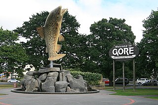
Gore is a town and district in the Southland region of the South Island of New Zealand. It has a resident population of 8,240 as of June 2023. Gore is known for its country music scene and hosts an annual country music festival. The town is also surrounded by farmland and is an important centre for agriculture in the region.
Mataura is a town in the Southland region of the South Island of New Zealand. Mataura has a meat processing plant, and until 2000 it was the site of a large pulp and paper mill.

Southland Girls' High School is a state girls' Year 7–13 secondary school in Georgetown, Invercargill, New Zealand.

Dacre is a small town in the South Island of New Zealand. It is situated on the Southland Plains between Invercargill and Edendale on State Highway 1. In Dacre, SH 1 is met by State Highway 98, which runs west to Makarewa via Rakahouka. Nearby villages include Mabel Bush to the northwest and Woodlands to the southeast. Dacre is 25 km north east of Invercargill, the closest city. The Main South Line railway passes just to the south of Dacre. It is a dairy farming community, that currently has a community hall and a small engine garage.
Tokanui is a community in the eastern portion of Southland District Council, located on the Southern Scenic Route about 56 km (35 mi) east of Invercargill and 107 km (66 mi) southwest of Balclutha, New Zealand. The Tokanui River runs just to the north of the village and occasionally floods the lower parts, as it did when the railway yard flooded in 1935.
Edendale is a town in the Southland region of New Zealand's South Island. The township is situated on the Southland Plains just to the west of the Mataura River. Before the town was called Edendale, it was known by the names Maorirua, Mataura Plains and Stuart's Bush.

Gore District Council is the territorial authority for the Gore District of New Zealand.
Gorge Road is a locality in the Southland region of New Zealand's South Island. It is on the Southern Scenic Route and is situated on the western bank of the Mataura River. Nearby settlements include Ashers to the west, and across the Mataura, Pine Bush and Titiroa to the east.
The Kaiwera Downs Wind Farm is a wind farm in the Southland region of New Zealand. It is consented to have a maximum capacity of 240 MW and use up to 83 turbines. Originally proposed by Trustpower, it is now owned and operated by Mercury Energy. The 10 turbine, 43 MW stage 1 of the project was opened in November 2023.
Mataura was a parliamentary electorate in the Southland Region of New Zealand, from 1866 to 1946.
Gore District is a district in the Southland Region of the South Island of New Zealand. It is named for Gore, the district's biggest township.
Waikaia, formerly known as Switzers, is a town in the Southland region of New Zealand's South Island. From 1909 until 1959, it was the terminus of the Waikaia Branch railway. The population in the 2013 census was 99, unchanged from the previous census in 2006.

Southland is New Zealand's southernmost region. It consists of the southwestern portion of the South Island and includes Stewart Island. Southland is bordered by the culturally similar Otago Region to the north and east, and the West Coast Region in the extreme northwest. The region covers over 3.1 million hectares and spans 3,613 km of coastline. As of June 2023, Southland has a population of 103,900, making it the eleventh-most-populous New Zealand region, and the second-most sparsely populated. Approximately half of the region's population lives in Invercargill, Southland's only city.
Garston is a small settlement in northern Southland, in the South Island of New Zealand, located close to the region's boundary with Otago. It is the most inland settlement in New Zealand. It is situated south of Lake Wakatipu and close to the upper reaches of the Mataura River, between Kingston and Lumsden. Garston is connected to both Kingston and Lumsden by SH 6.
Mataura Island is a farming community in Southland, New Zealand. It is located close to the east bank of the lower reaches of the Mataura River. Despite its name, it is no longer an island. Mataura Island is located some 40 kilometres (25 mi) east of the region's main city of Invercargill, and 15 kilometres (9.3 mi) south of the town of Edendale, on the Awarua Plains and close to the western edge of The Catlins.
The Ensign is a regional newspaper based in Gore, New Zealand published on Wednesdays and Fridays by Allied Press Ltd. It was first published in 1878 as The Mataura Ensign and changed to its current name in 1973. The newspaper features coverage of local government, sports and recreation, arts and entertainment, education, farming and business news. It is currently distributed to approximately 12,000 homes over a circulation area that includes Gore and the surrounding area that stretches from Mandeville and Waikaka in the north to Mataura in the south.
Waimumu is a rural settlement in the Gore District and Southland Region of New Zealand's South Island. It is located southwest of Gore, about 14 kilometres from the main township.
East Gore Presbyterian Church is a former Presbyterian church located in Gore, New Zealand. It is located on a bluff overlooking the eastern side of the Mataura River.
Menzies Ferry is a farming locality on the west side of the Mataura River in the east of Southland District, in the south of New Zealand. It gained its name from Dr. James Alexander Robertson Menzies, who supplied a boat to ferry passengers across the Mataura. It was surveyed as a township in 1876.
