Related Research Articles
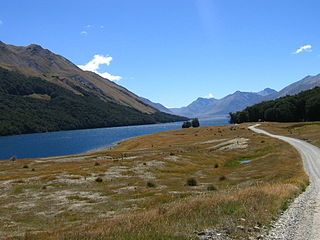
Mavora Lakes is a protected area in the South Island of New Zealand consisting of two lakes: North Mavora and South Mavora. The lakes are drained by the Mararoa River. The area is managed by the Department of Conservation, and is part of Te Wahipounamu, a World Heritage Area.
The Ascetosporea are a group of eukaryotes that are parasites of animals, especially marine invertebrates. The two groups, the haplosporids and paramyxids, are not particularly similar morphologically, but consistently group together on molecular trees, which place them near the base of the Cercozoa. Both produce spores without the complex structures found in similar groups.
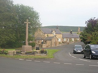
Chatton is a village in Northumberland, in England. It is roughly 6 km (3.7 mi) to the east of Wooler.
The Syndiniales are an order of early branching dinoflagellates, found as parasites of crustaceans, fish, algae, cnidarians, and protists. The trophic form is often multinucleate, and ultimately divides to form motile spores, which have two flagella in typical dinoflagellate arrangement. They lack a theca and chloroplasts, and unlike all other orders, the nucleus is never a dinokaryon. A well-studied example is Amoebophrya, which is a parasite of other dinoflagellates and may play a part in ending red tides. Several MALV groups have been assigned to Syndiniales; recent studies, however, show paraphyly of MALVs suggesting that only those groups that branch as sister to dinokaryotes belong to Syndiniales.
Borchgrevink Glacier is a large glacier in the Victory Mountains, Victoria Land, Antarctica. It drains south between Malta Plateau and Daniell Peninsula, and thence projects into Glacier Strait, Ross Sea, as a floating glacier tongue.

Weirsdale is a town in Marion County, Florida, United States. It is located near the intersection of State Road 25 and State Road 42. The community is part of the Ocala Metropolitan Statistical Area.
Gore District Council is the territorial authority for the Gore District of New Zealand.
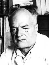
Édouard Chatton was a French biologist who first characterized the distinction between the prokaryotic and eukaryotic cellular types.

Cyclic AMP-dependent transcription factor ATF-7 is a protein that in humans is encoded by the ATF7 gene.
Simpson Glacier is a glacier, 6 nautical miles, in the Admiralty Mountains, Antarctica. It flows northward to the coast between Nelson Cliff and Mount Cherry-Garrard where it forms the Simpson Glacier Tongue.
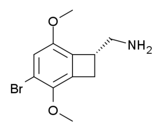
TCB-2 is a hallucinogen discovered in 2006 by Thomas McLean working in the lab of David Nichols at Purdue University. It is a conformationally-restricted derivative of the phenethylamine 2C-B, also a hallucinogen, and acts as a potent agonist for the 5-HT2A and 5-HT2C receptors with a Ki of 0.26 nM at the human 5-HT2A receptor. In drug-substitution experiments in rats, TCB-2 was found to be of similar potency to both LSD and Bromo-DragonFLY, ranking it among the most potent phenethylamine hallucinogens yet discovered. This high potency and selectivity has made TCB-2 useful for distinguishing 5-HT2A mediated responses from those produced by other similar receptors. TCB-2 has similar but not identical effects in animals to related phenethylamine hallucinogens such as DOI, and has been used for studying how the function of the 5-HT2A receptor differs from that of other serotonin receptors in a number of animal models, such as studies of cocaine addiction and neuropathic pain.
Kadoli is a village in the southern state of Karnataka, India. It is located in the Belgaum taluk of Belgaum district in Karnataka.
Chatton is an unincorporated community in Houston Township, Adams County, Illinois, United States. Chatton is north of Golden.
Trangie is a closed railway station on the Main Western railway line in Trangie, New South Wales, Australia. The station opened in 1883, initially as a passing loop and siding, the only one between Narromine and Nevertire. It was named after Trangie Station, a local pastoral holding. The station consists of a side platform and station building which survives in good condition.
Duboscquella is a genus of dinoflagellates.

Lufwanyama District with headquarters at Lufwanyama is a large rural undeveloped district in the west of Copperbelt Province. On a number of maps it is mixed up with Mpongwe District and Masaiti District. At one time these three districts were known as 'Ndola Rural'. As of the 2010 Zambian Census, the district had a population of 78,503 people. It has an area of 9849 square kilometres.
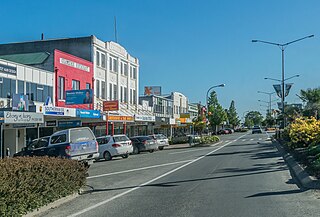
Gore District is a district in the Southland Region of the South Island of New Zealand. It is named for Gore, the district's biggest township.
The Chatton transmitting station is a broadcasting and telecommunications facility, between Wooler and Seahouses, Northumberland. It is owned and operated by Arqiva, and situated within the boundary of Bewick and Beanley Moors SSSI.
Daymar is a rural town and locality in the Goondiwindi Region, Queensland, Australia. In the 2021 census, the locality of Daymar had a population of 41 people.
Waikaka is a town in Southland, New Zealand. It was a gold-mining town in the 19th century, starting in 1867 when gold was found. Over NZ£1,000,000 equivalent of gold was eventually extracted from this location. The town was served by the Waikaka branch railway.
References
45°59′06″S168°55′28″E / 45.9849°S 168.9244°E
| | This Southland Region geography article is a stub. You can help Wikipedia by expanding it. |