Otago is a region of New Zealand located in the southern half of the South Island administered by the Otago Regional Council. It has an area of approximately 32,000 square kilometres (12,000 sq mi), making it the country's second largest local government region. Its population was 254,600 in June 2023.
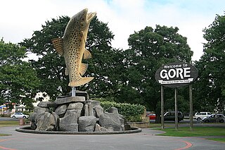
Gore is a town and district in the Southland region of the South Island of New Zealand. It has a resident population of 8,240 as of June 2023. Gore is known for its country music scene and hosts an annual country music festival. The town is also surrounded by farmland and is an important centre for agriculture in the region.

Invercargill is the southernmost and westernmost city in New Zealand, and one of the southernmost cities in the world. It is the commercial centre of the Southland region. The city lies in the heart of the wide expanse of the Southland Plains to the east of the Ōreti or New River some 18 km north of Bluff, which is the southernmost town in the South Island. It sits amid rich farmland that is bordered by large areas of conservation land and marine reserves, including Fiordland National Park covering the south-west corner of the South Island and the Catlins coastal region.
The Southland Plains is a general name given to several areas of low-lying land in the South Island of New Zealand, separated by the rise of the Hokonui Hills in the north. It forms a sizeable area of Southland region and encompasses its two principal settlements the city of Invercargill and the town of Gore. The Southland Plains include some of New Zealand's most fertile farmland.

Toetoes Bay is the easternmost of three large bays lying on the Foveaux Strait coast of Southland, New Zealand, the others being Te Waewae Bay and Oreti Beach. The 240 km Mataura River drains to sea at Toetoes Bay, first passing through the Toetoes Harbour estuary. Thirty kilometres in length, the bay is the southern end of the Awarua Plain, an area of swampy land stretching inland for about fifteen kilometres. The eastern end of the bay is close to Slope Point, the South Island's southernmost point, and the western end of the Catlins.
The Aparima River, earlier known as Jacob's River, is one of the southward-flowing braided rivers of Southland, New Zealand.
The Makarewa River is the largest tributary of the Ōreti River, and is in Southland, New Zealand. It flows for 60 kilometres (37 mi) from its source in the Hokonui Hills, joining the Ōreti just north of Invercargill.

In structural geology, a syncline is a fold with younger layers closer to the center of the structure, whereas an anticline is the inverse of a syncline. A synclinorium is a large syncline with superimposed smaller folds. Synclines are typically a downward fold (synform), termed a synformal syncline, but synclines that point upwards can be found when strata have been overturned and folded.
Dipton is a small town in the Southland region of New Zealand. It is located 20 kilometres south of Lumsden and 60 kilometres north of Invercargill. From 20 October 1875 until its closure on 13 December 1982, Dipton was situated on the Kingston Branch railway.

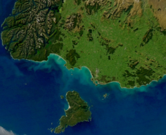
Hokonui is an Adult Contemporary radio station that first launched in Gore, New Zealand, broadcasting across Southland and now also broadcasts across South Otago and Mid Canterbury. Hokonui also from April 2015 was broadcasting in Taranaki until late in 2020 when it was disestablished by NZME and replaced by Gold AM. The name Hokonui comes from the Hokonui Hills which can clearly be seen in Gore and the Southland Plains.
Waitane is a locality in the Southland region of New Zealand's South Island in the foothills of the Hokonui Hills. It is located in a rural setting on State Highway 96 between Glencoe and Te Tipua. The nearest sizeable town is Mataura to the east, while the main city of Southland, Invercargill, is southwest.

State Highway 6 is a major New Zealand state highway. It extends from the Marlborough region in the northeastern corner of the South Island across the top of the island, then down the length of the island, initially along the West Coast and then across the Southern Alps through inland Otago and finally across the Southland Plains to the island's south coast. Distances are measured from north to south.

State Highway 94 is a New Zealand state highway connecting the large Southland town of Gore with one of New Zealand's most popular destinations, Milford Sound. It also passes the significant townships of Lumsden and Te Anau as well going through the Homer Tunnel. The road also goes through Fiordland and crosses the Main Divide of the Southern Alps.
State Highway 96 is a New Zealand state highway connecting the Southland communities of Mataura, Winton, and Ohai. Starting at State Highway 1 the highway is 92 kilometres (57 mi) in length and runs in a general east–west direction. In Winton State Highway 96 runs concurrently with State Highway 6 for 1.6 kilometres (0.99 mi) kilometres.
Hokonui was a parliamentary electorate in the Southland region of New Zealand, from 1881 to 1890.
Gilbert Trevor Moffitt was a New Zealand artist, arguably one of the country's leading narrative painters. Moffitt's expressionist paintings reveal the lives and stories of ordinary working New Zealanders.

Southland is New Zealand's southernmost region. It consists of the southwestern portion of the South Island and includes Stewart Island. Southland is bordered by the culturally similar Otago Region to the north and east, and the West Coast Region in the extreme northwest. The region covers over 3.1 million hectares and spans 3,613 km of coastline. As of June 2023, Southland has a population of 103,900, making it the eleventh-most-populous New Zealand region, and the second-most sparsely populated. Approximately half of the region's population lives in Invercargill, Southland's only city.
The term Hokonui refers to several things in New Zealand, all directly or indirectly related to the area around the Southland town of Gore:

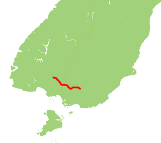
The Southland Syncline is a major geological structure located in the Southland Region of New Zealand's South Island. The syncline folds the Mesozoic greywackes of the Murihiku Terrane. The northern limb of the fold is steep to overturned, while the southern limb dips shallowly to the northeast. The axial plan dips to the northeast and the axis plunges to the southeast.

The Southland temperate forests is a temperate broadleaf and mixed forests ecoregion on New Zealand's South Island. The natural vegetation was mostly forest, but over the centuries human activities, including grazing and fires, replaced much of the original forest with grassland and agriculture.