Related Research Articles
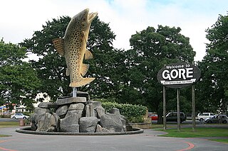
Gore is a town and district in the Southland region of the South Island of New Zealand. It has a resident population of 8,240 as of June 2023. Gore is known for its country music scene and hosts an annual country music festival. The town is also surrounded by farmland and is an important centre for agriculture in the region.

Riverton, officially Riverton / Aparima, is a small New Zealand town 30 kilometres (19 mi) west of Invercargill, on the south-eastern shorelines of the Jacobs River Estuary. The estuary is formed by the Aparima and Pourakino rivers, leading through a narrow outflow channel into Foveaux Strait. Accessible via State Highway 99 on the Southern Scenic Route, the main part of the town is on flat land and the northern end of Oreti Beach. South Riverton is built on the hills between the eastern shore of the estuary and Taramea Bay.

The Mataura River is in the Southland Region of the South Island of New Zealand. It is 240 kilometres (150 mi) long.

Tiwai Point lies at the entrance to Bluff Harbour on the southern coast of the South Island of New Zealand. A spit which extends from the western end of the Awarua Plain, it lies between Awarua Bay to the north and Foveaux Strait to the south. It is known for the Tiwai Point Aluminium Smelter, one of the largest industrial facilities in New Zealand.
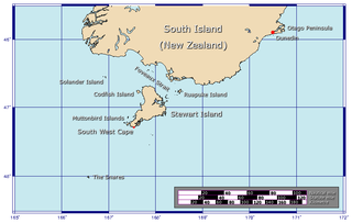
Foveaux Strait is a strait that separates Stewart Island from the South Island of New Zealand. The width of the strait ranges from about 23 to 53 km, and the depth varies between 18 and 46 m. The strait was first charted by an American sealer, Owen Folger Smith. He charted the strait from a whaleboat of the sealing brig Union in 1804.
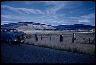
The Southland Plains is a general name given to several areas of low-lying land in the South Island of New Zealand, separated by the rise of the Hokonui Hills in the north. It forms a sizeable area of Southland region and encompasses its two principal settlements the city of Invercargill and the town of Gore. The Southland Plains include some of New Zealand's most fertile farmland.

Oreti Beach is the central bay of three lying on the Foveaux Strait coast of Southland, New Zealand, the others being Te Waewae Bay and Toetoes Bay. Twenty-six kilometres in length, the bay lies between the town of Riverton and the outflow of the Aparima River in the northwest, and the estuary of the Ōreti River in the southeast.

The Ōreti River is one of the main rivers of Southland, New Zealand, and is 170 kilometres (110 mi) long. The river has been identified as an Important Bird Area by BirdLife International because, for much of its length, it supports breeding colonies of black-billed gulls.

The Hokonui Hills, also known as The Hokonui Mountains or simply The Hokonui, are a range of hills in central Southland, New Zealand. They rise to 600 metres above the surrounding Southland Plains, of which the hills mark a northern extremity.

Moturoa / Rabbit Island is a small island that lies across the southernmost part of Tasman Bay / Te Tai-o-Aorere, on the northern coast of New Zealand's South Island. The long narrow island runs east–west for 8 kilometres (5 mi), and covers 15 km2 (5.8 sq mi).

The Rakaia River is in the Canterbury Plains in New Zealand's South Island. The Rakaia River is one of the largest braided rivers in New Zealand. The Rakaia River has a mean flow of 203 cubic metres per second (7,200 cu ft/s) and a mean annual seven-day low flow of 87 m3/s (3,100 cu ft/s). In the 1850s, European settlers named it the Cholmondeley River, but this name lapsed into disuse. The name Rakaia comes from Māori "Ō Rakaia", meaning the place where people were arranged by ranks.

The Southland Province was a province of New Zealand from March 1861, when it split from Otago Province, until 1870, when it rejoined Otago.

Pahia is a small rural locality in coastal Southland, New Zealand, not to be confused with the North Island tourist resort of Paihia. Surrounding areas include Ruahine, Wakapatu, Round Hill, Colac Bay and Orepuki. The main road, Orepuki-Riverton Hwy, runs through it. Pahia is 15 minutes from Riverton, 20 minutes from Tuatapere and 45 minutes from Invercargill.
Thornbury is a small township on the east bank of the lower Aparima River, in western Southland, New Zealand. It is approximately 10 km (6.2 mi) northeast of Riverton, and 31 km (19 mi) northwest of Invercargill. It is mainly a farming service community. Local small industries include machinery and transport/trucking companies, and a tannery.
Otautau is a small farming, forestry and milling town located inland on the western edge of the Southland Plains of New Zealand on the banks of the Aparima River. Otautau is located approximately 40 kilometres (25 mi) north west of Invercargill. The average elevation of Otautau is 60 metres.
The Longwood Range is a range of hills to the west of the Southland Plains, Southland, New Zealand. From the 1860s until the 1950s gold mining was prevalent in the Longwood Ranges. There are many small towns and localities situated around the periphery of these hills: clockwise from the south-east, these include Riverton, Pourakino Valley, Colac Bay, Pahia, Orepuki, Tuatapere, Otautau and Thornbury.

Southland is New Zealand's southernmost region. It consists of the southwestern portion of the South Island and includes Stewart Island. Southland is bordered by the culturally similar Otago Region to the north and east, and the West Coast Region in the extreme northwest. The region covers over 3.1 million hectares and spans 3,613 km of coastline. As of June 2023, Southland has a population of 103,900, making it the eleventh-most-populous New Zealand region, and the second-most sparsely populated. Approximately half of the region's population lives in Invercargill, Southland's only city.
The Eyre Creek is a river in the Southland region of New Zealand's South Island. It is a tributary of the Mataura River with a braided channel and with its confluence near the small town of Athol. It rises on the eastern side of Jane Peak in the Eyre Mountains south-west of Lake Wakatipu. It has been identified as an Important Bird Area by BirdLife International because it supports breeding colonies of the endangered black-billed gull. West of Athol it is crossed by State Highway 6 and the Around the Mountains Cycle Trail.
Gummies Bush is a farming locality in Southland, New Zealand, 10 kilometres (6.2 mi) west of the Aparima River, 9 kilometres (5.6 mi) north of Riverton, and 18 kilometres (11 mi) south from Otautau. It is said to be named after whaler and later pig-farmer James Leader, nicknamed "Gummie" because he had no teeth. Leader had a camp in the bush in this location. To Māori, the area was known as Opuaki. It was apparently named after a person, Puaki, a word which means "to come forth in position," or "to come forth in language – that is to utter.
Waipango is a farming locality in Southland, New Zealand, on the flat between the lower reaches of the Pourakino and Aparima Rivers. It is 8 km north-west of Riverton, 14 km south-west of Thornbury, and 14 km north-east of Colac Bay. The name, from the Māori language, literally translates as Wai meaning water, and pango meaning black.
References
- ↑ Grant, David (13 May 2015). "Southland places - Riverton / Aparima". Te Ara: The Encyclopedia of New Zealand . Retrieved 8 November 2015.
- ↑ "Aparima River". BirdLife data zone: Important Bird Areas. BirdLife International. 2012. Archived from the original on 10 July 2007. Retrieved 15 November 2012.
46°20′S168°01′E / 46.333°S 168.017°E