Lake Te Anau

Last updated

Lake Te Anau
Māori: Te Ana-au
On Lake Te Anau.jpg
Lake Te Anau
Lake Te Anau
NZ-SI plain map.png
Disc Plain red.svg
Lake Te Anau
NZ-L Te Anau.png
Lake Te Anau
Location Southland District, Southland Region, South Island
Coordinates 45°12′S167°48′E / 45.200°S 167.800°E / -45.200; 167.800
Primary inflows Eglinton River, Clinton River, Worsley River, Glaisnock River, Wapiti River, Doon River, McKenzie Burn, Upukerora River
Primary outflows Waiau River
Basin  countriesNew Zealand
Max. length65 km (40 mi)
Surface area344 km2 (133 sq mi)
Average depth168.8 m (554 ft)
Max. depth425 m (1,394 ft)
Water volume58.06 km3 (13.93 cu mi)
Surface elevation210 m (690 ft)
Settlements Te Anau

Lake Te Anau (Māori : Te Ana-au) [1] is in the southwestern corner of the South Island of New Zealand. The lake covers an area of 344 km2 (133 sq mi), making it the second-largest lake by surface area in New Zealand (after Lake Taupō) and the largest in the South Island. It is the second largest lake in Australasia by fresh water volume. [2] The main body of the lake runs north-south, and is 65 km in length. Three large fiords form arms to the lake on its western flank: North Fiord, Middle Fiord and South Fiord. These are the only inland fiords that New Zealand has, the other 14 are out on the coast. Several small islands lie in the entrance to Middle Fiord, which forks partway along its length into northwest and southwest arms. The surface of the lake is at an altitude of 210 m. It has a maximum depth of 425 m, [3] so much of its bed lies below sea level, with the deepest part of the lake being 215 metres below sea level.

Contents

The Lake Te Anau control gates which control the flow of water from Lake Te Anau into the Waiau river and maintain the water level between 201.5 and 202.7 metres above sea level. Te Anau control gates.jpg
The Lake Te Anau control gates which control the flow of water from Lake Te Anau into the Waiau river and maintain the water level between 201.5 and 202.7 metres above sea level.

Several rivers feed the lake, of which the most important is the Eglinton River, which joins the lake from the east, opposite the entrance to North Fiord. The outflow is the Waiau River, which flows south for several kilometres into Lake Manapouri. The town of Te Anau lies at the south-eastern corner of the lake, close to the outflow.

Most of the lake is within Fiordland National Park and the Te Wahipounamu World Heritage Site, the latter of which was officially recognised internationally in 1990. Other than the Te Anau township, the only human habitation close to the lake is the farming settlement of Te Anau Downs, close to the mouth of the Eglinton River. Between these two settlements the land is rolling hill country, but elsewhere the land is mountainous, especially along its western shore, where the Kepler and Murchison Mountains rise 1,400 m above the surface of the lake.

Lake Te Anau was important for the Ngāi Tahu iwi [lower-alpha 1] in pre-European times as the area was a traditional stopping point on their trails between the east and west coasts of the South Island of New Zealand, where they obtained food and resources. The lake was first discovered by European explorers Charles Naim and William Stephen in 1852.

Two New Zealand Great Walks start at the lake. The Milford Track starts at the northern tip of the lake and the Kepler Track starts and ends at the south tip of the lake at the Waiau River.

Name

The English translation of the Māori name Te Anau has been disputed. It was supposed by many that Te Anau was the name of the granddaughter of Hekeia, a chief of the Waitaha tribe, whose name now belongs to a mountain on the Longwood Range. [5] [6] When the Te Ana-au Caves were rediscovered in 1948, earlier explanations of the name were replaced by the interpretation of the full name Te Ana-au, Māori for 'The cave of swirling water'. [7]

Flora and fauna

Numerous species of wildlife and vegetation are found in the watershed of Lake Te Anau. Vegetative understory includes numerous fern species including the crown fern, Blechnum discolor . [8]

Several species of endangered birds live around the shores of Lake Te Anau, notably the takahē (Notornis hochstetteri). An area between the Middle and South Fiords called the Murchison Mountains is a sanctuary set aside for these birds. The western shore of the lake also features the Te Ana-au Caves.

Recreation

Throughout summer the lake is used for boating, fishing, kayaking, swimming and access to Fiordland National Park. The lake is home to both the Marakura Yacht Club and the Te Anau Boating Club. [9] Every year on the weekend of Labour Day a fishing competition is held. [10]

See also

Notes

  1. The Māori word for tribe

Related Research Articles

<span class="mw-page-title-main">Fiordland</span> Geographical region of New Zealand

Fiordland is a geographical region of New Zealand in the south-western corner of the South Island, comprising the westernmost third of Southland. Most of Fiordland is dominated by the steep sides of the snow-capped Southern Alps, deep lakes, and its steep, glacier-carved and now ocean-flooded western valleys. The name "Fiordland" comes from a variant spelling of the Scandinavian word for this type of steep valley, "fjord". The area of Fiordland is dominated by, and very roughly coterminous with, Fiordland National Park, New Zealand's largest National Park.

<span class="mw-page-title-main">Browne Falls</span> Waterfall in Doubtful Sound, New Zealand

Browne Falls is a waterfall above Doubtful Sound, which is located in Fiordland National Park, New Zealand. In a temperate rain forest, the falls cascade down to the fiord near Hall Arm. Heights of 619 metres and 836 metres have been given for the falls. Their source is a tarn called Lake Browne which when full, overflows down the side of the mountain face. The stream makes 836 m height difference over 1,130 m horizontal difference, thus the mean gradient of stream is 42 degrees. This comparatively low angle makes the falls less impressive.

<span class="mw-page-title-main">Fiordland National Park</span> National park on South Island of New Zealand

Fiordland National Park occupies the southwest corner of the South Island of New Zealand. It is by far the largest of the 13 national parks in New Zealand, with an area of 12,607 square kilometres (4,868 sq mi), and a major part of the Te Wahipounamu World Heritage Site. The park is administered by the Department of Conservation.

<span class="mw-page-title-main">Doubtful Sound / Patea</span> Fiord in New Zealand

Doubtful Sound / Patea is a fiord in Fiordland, in the far south west of New Zealand. It is located in the same region as the smaller but more famous and accessible Milford Sound / Piopiotahi. It took second place after Milford Sound as New Zealand's most famous tourism destination.

<span class="mw-page-title-main">Lake Manapouri</span> Lake in Southland Region, New Zealand

Lake Manapouri is located in the South Island of New Zealand. The lake is situated within the Fiordland National Park and the wider region of Te Wahipounamu South West New Zealand World Heritage Area.

<span class="mw-page-title-main">Te Anau</span> Town in Southland, New Zealand

Te Anau is a town in the Southland region of the South Island of New Zealand. In Māori, Te-Anau means the Place of the Swirling Waters. It is on the eastern shore of Lake Te Anau in Fiordland. Te Anau is 155 kilometres north of Invercargill and 171 kilometres to the southwest of Queenstown. Manapouri lies 21 kilometres to the south. Te Anau lies at the southern end of the Milford Road, 117 kilometres to the south of Milford Sound.

<span class="mw-page-title-main">Manapouri</span> Town in Fiordland, New Zealand

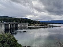
Manapouri is a small town in Southland / Fiordland, in the southwest corner of the South Island, in New Zealand. The township is the westernmost municipality in New Zealand. Located at the edge of the Fiordland National Park, on the eastern shore of Lake Manapouri, close to its outflow into the Waiau River, tourist boat services are based in the town.

<span class="mw-page-title-main">Eglinton River</span> River in New Zealand

The Eglinton River is located in the region of Southland in the southwest of New Zealand. It flows through Fiordland National Park for 50 kilometres (31 mi). Its headwaters are at Lake Gunn, 25 kilometres (16 mi) east of Milford Sound, and it flows generally south before entering Lake Te Anau along the lake's eastern shore opposite the entrance to North Fiord.

<span class="mw-page-title-main">Lake Monowai</span> Lake in Southland Region, New Zealand

Lake Monowai is a large lake in the southern part of Fiordland National Park, in New Zealand's South Island, 120 kilometres northwest of Invercargill. At an altitude of 180 metres in a long curved valley, the lake appears on maps shaped like a letter "U". The western part of the lake is set in beautiful mountainous country. It is drained in the northeast by the short Monowai River, which enters the Waiau River eight kilometres to the northeast.

<span class="mw-page-title-main">Lake Hauroko</span> Lake in the South Island of New Zealand

Lake Hauroko is the deepest lake in New Zealand. The lake, which is 462 metres deep, is located in a mountain valley in Fiordland National Park.

<span class="mw-page-title-main">Te Ana-au Caves</span> Cave

The Te Ana-au caves are a culturally and ecologically important system of limestone caves on the western shore of Lake Te Anau, in the southwest of New Zealand. They were re-discovered in 1948 by Lawson Burrows, who found the upper entry after three years of searching, following clues in old Māori legends. It later became a major tourist attraction for the area, as the part of the caverns close to the lake shore is home to glowworms. The unofficial name used by the national caving association is Aurora. The caves are geologically young and hence there is only one tiny stalactite.

<span class="mw-page-title-main">Waiau River (Southland)</span> River in New Zealand

The Waiau River is the largest river in the Southland region of New Zealand. 'Waiau' translates to 'River of Swirling Currents'. It is the outflow of Lake Te Anau, flowing from it into Lake Manapouri 10 kilometres (6 mi) to the south, and from there flows south for 70 kilometres (43 mi) before reaching the Foveaux Strait 8 kilometres (5 mi) south of Tuatapere. It also takes water from Lake Monowai.

<span class="mw-page-title-main">Kepler Track</span> New Zealand tramping track

The Kepler Track is a 60 km (37 mi) circular hiking track which travels through the landscape of the South Island of New Zealand and is situated near the town of Te Anau. The track passes through many landscapes of the Fiordland National Park such as rocky mountain ridges, tall mossy forests, lake shores, deep gorges, rare wetlands and rivers. Like the mountains it traverses, the track is named after Johannes Kepler. The track is one of the New Zealand Great Walks and is administered by the Department of Conservation (DOC).

<span class="mw-page-title-main">Kepler Challenge</span>

The Kepler Challenge Mountain Run is the premier mountain running event in New Zealand and follows the 60 km Kepler Track through the Fiordland National Park. It has been held annually since 1988, and draws competitors from throughout New Zealand and around the world. Around 450 runners enter the event with nearly all completing the demanding course.

<span class="mw-page-title-main">Pomona Island</span> Island in New Zealand

Pomona Island is the largest island within Lake Manapouri, in Fiordland National Park, in New Zealand's South Island. With an area of 262 hectares, it is the largest island to be found within any New Zealand lake.

<span class="mw-page-title-main">Southland Region</span> Region of New Zealand

Southland is New Zealand's southernmost region. It consists mainly of the southwestern portion of the South Island and Stewart Island/Rakiura. It includes Southland District, Gore District and the city of Invercargill. Murihiku Southland is bordered by the culturally similar Otago to the north and east, and the West Coast in the extreme northwest. The region covers over 3.1 million hectares and spans 3,613 km of coast. As of June 2023, Southland has a population of 103,900, making it the eleventh-most-populous New Zealand region, and the second-most sparsely populated.

<span class="mw-page-title-main">Southern Lakes (New Zealand)</span>

The Southern Lakes is an unofficial name given to an area of the southern South Island of New Zealand. Despite being an unofficial designation, the term Southern Lakes is sometimes used by organisations such as the New Zealand Meteorological Service and Automobile Association. Though exact definitions vary, the area encompasses parts of western Southland and Central Otago, and is occasionally extended to include the Mackenzie Basin of inland Canterbury, a total of roughly 28,000 to 35,000 square kilometres.

Te Houhou / George Sound is a fiord of the South Island of New Zealand. It is one of the fiords that form the coast of Fiordland.

<span class="mw-page-title-main">Taipari Roa (Elizabeth Island) Marine Reserve</span> Marine reserve in New Zealand territorial waters

Taipari Roa Marine Reserve is a marine reserve covering an area of 613 hectares around Elizabeth Island, in the inner Doubtful Sound / Patea of Fiordland on New Zealand's South Island. It was established in 2005 and is administered by the Department of Conservation.

References

  1. Esler, Lloyd (11 November 2022). "Te Anau - a name with a misty history". Stuff. Retrieved 18 December 2023.
  2. "Archived copy" (PDF). Archived from the original (PDF) on 23 May 2010. Retrieved 30 August 2009.{{cite web}}: CS1 maint: archived copy as title (link)
  3. "Lakes in New Zealand". Ministry for the Environment. Archived from the original on 15 October 2008.
  4. "Lake levels". Meridian Energy. Retrieved 5 May 2023.
  5. McLintock, A. H. (1966). "Te Anau, Lake". Te Ara – The Encyclopedia of New Zealand. Retrieved 6 September 2015.
  6. Taylor, W. A. (1952). "Murihiki". Lore and History of the South Island Maori. Bascands. p. 148. Retrieved 6 September 2015.
  7. "Te Anau". NZHistory. Ministry of Culture and Heritage. Retrieved 25 September 2015.
  8. C. Michael Hogan. 2009
  9. "Te Anau Boating Club" . Retrieved 15 February 2017.
  10. "Te Anau Manapouri Fishing Classic" . Retrieved 15 February 2017.

Sources