
The Cook Islands is a self-governing island country in the South Pacific Ocean in free association with New Zealand. It comprises 15 islands whose total land area is 240 square kilometres (93 sq mi). The Cook Islands' Exclusive Economic Zone (EEZ) covers 1,960,027 square kilometres (756,771 sq mi) of ocean.
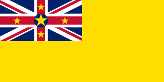
Niue is a self-governing territory of New Zealand in the South Pacific Ocean, 2,400 kilometres (1,500 mi) northeast of New Zealand. Niue's land area is about 261 square kilometres (101 sq mi) and its population, predominantly Polynesian, was about 1,600 in 2016. Niue is located in a triangle between Tonga, Samoa, and the Cook Islands. It is 604 kilometres northeast of Tonga. The island is commonly referred to as "The Rock", which comes from the traditional name "Rock of Polynesia". Niue is one of the world's largest coral islands. The terrain of the island has two noticeable levels. The higher level is made up of a limestone cliff running along the coast, with a plateau in the centre of the island reaching approximately 60 metres above sea level. The lower level is a coastal terrace approximately 0.5 km wide and about 25–27 metres high, which slopes down and meets the sea in small cliffs. A coral reef surrounds the island, with the only major break in the reef being in the central western coast, close to the capital, Alofi.

Oceania is a geographical region that is described as a continent in some parts of the world. It includes Australasia, Melanesia, Micronesia, and Polynesia. Spanning the Eastern and Western hemispheres, at the center of the water hemisphere, Oceania is estimated to have a land area of 8,525,989 square kilometres (3,291,903 sq mi) and a population of around 44.4 million as of 2022. Oceania is described as a geographical region in most of the English-speaking world, but outside of the English-speaking world, Oceania is described as one of the continents. In this model of the world, Australia is either seen as an island or a continental landmass contained inside of the larger continent of Oceania. When compared to the other continents, Oceania is the smallest in land area and the second-least populated after Antarctica.

Samoa, officially the Independent State of Samoa and until 1997 known as Western Samoa, is a Polynesian island country consisting of two main islands ; two smaller, inhabited islands ; and several smaller, uninhabited islands, including the Aleipata Islands. Samoa is located 64 km (40 mi) west of American Samoa, 889 km (552 mi) northeast of Tonga, 1,152 km (716 mi) northeast of Fiji, 483 km (300 mi) east of Wallis and Futuna, 1,151 km (715 mi) southeast of Tuvalu, 519 km (322 mi) south of Tokelau, 4,190 km (2,600 mi) southwest of Hawaii, and 610 km (380 mi) northwest of Niue. The capital and largest city is Apia. The Lapita people discovered and settled the Samoan Islands around 3,500 years ago. They developed a Samoan language and Samoan cultural identity.

Tokelau is a dependent territory of New Zealand in the southern Pacific Ocean. It consists of three tropical coral atolls: Atafu, Nukunonu, and Fakaofo. They have a combined land area of 10 km2 (4 sq mi). The capital rotates yearly among the three atolls. In addition to these three, Swains Island, which forms part of the same archipelago, is the subject of an ongoing territorial dispute; it is currently administered by the United States as part of American Samoa. Tokelau lies north of the Samoan Islands, east of Tuvalu, south of the Phoenix Islands, southwest of the more distant Line Islands, and northwest of the Cook Islands.

Zealand at 7,031 km2 is the largest and most populous island in Denmark proper. Zealand had a population of 2,319,705 on 1 January 2020.

The North Island, also officially named Te Ika-a-Māui, is one of the two main islands of New Zealand, separated from the larger but less populous South Island by Cook Strait. With an area of 113,729 km2 (43,911 sq mi), it is the world's 14th-largest island. It has a population of 3,922,000, which is 77% of New Zealand's residents, making it the most populous island in Polynesia and the 28th-most-populous island in the world.

The South Island, also officially named Te Waipounamu, is the larger of the two major islands of New Zealand in surface area, the other being the smaller but more populous North Island. It is bordered to the north by Cook Strait, to the west by the Tasman Sea, and to the south and east by the Pacific Ocean. The South Island covers 150,437 square kilometres (58,084 sq mi), making it the world's 12th-largest island. At low altitude, it has an oceanic climate.

Moa are an extinct group of flightless birds formerly endemic to New Zealand. During the Late Pleistocene-Holocene, there were nine species. The two largest species, Dinornis robustus and Dinornis novaezelandiae, reached about 3.6 metres (12 ft) in height with neck outstretched, and weighed about 230 kilograms (510 lb) while the smallest, the bush moa, was around the size of a turkey. Estimates of the moa population when Polynesians settled New Zealand circa 1300 vary between 58,000 and approximately 2.5 million.

The Auckland Islands are an archipelago of New Zealand, lying 465 kilometres (290 mi) south of the South Island. The main Auckland Island, occupying 510 km2 (200 sq mi), is surrounded by smaller Adams Island, Enderby Island, Disappointment Island, Ewing Island, Rose Island, Dundas Island, and Green Island, with a combined area of 626 km2 (240 sq mi). The islands have no permanent human inhabitants.

The Chatham Islands are an archipelago in the Pacific Ocean about 800 km (430 nmi) east of New Zealand's South Island. They are administered as part of New Zealand. The archipelago consists of about 10 islands within an approximate 60 km (30 nmi) radius, the largest of which are Chatham Island and Pitt Island (Rangiauria). They include New Zealand's easternmost point, the Forty-Fours. Some of the islands, formerly cleared for farming, are now preserved as nature reserves to conserve some of the unique flora and fauna.

Pacific Islanders, Pasifika, Pasefika, Pacificans or rarely Pacificers are the peoples of the Pacific Islands. As an ethnic/racial term, it is used to describe the original peoples—inhabitants and diasporas—of any of the three major subregions of Oceania.

The South Island takahē is a flightless swamphen indigenous to New Zealand and the largest living member of the rail family. It is often known by the abbreviated name takahē, which it shares with the recently extinct North Island takahē. The two takahē species are also known as notornis.
Time in New Zealand is divided by law into two standard time zones. The main islands use New Zealand Standard Time (NZST), 12 hours in advance of Coordinated Universal Time (UTC) / military M (Mike), while the outlying Chatham Islands use Chatham Standard Time (CHAST), 12 hours 45 minutes in advance of UTC / military M^ (Mike-Three).

The Realm of New Zealand is the area over which the monarch of New Zealand is head of state. The realm is not a federation but is a collection of states and territories united under its monarch. New Zealand is an independent and sovereign state that has one territory in Antarctica, one dependent territory (Tokelau), and two associated states. The Realm of New Zealand encompasses the three autonomous jurisdictions of New Zealand, the Cook Islands, and Niue.

The states and territories are administrative divisions in Australia, ruled by regional governments that constitute the level of governance between the federal government and local governments. States are self-governing polities with incomplete sovereignty and their own constitutions, legislatures, departments, and certain civil authorities that administer and deliver most public policies and programs. Territories can be autonomous and administer local policies and programs much like the states in practice, but are still constitutionally and financially subordinate to the federal government and thus have no true sovereignty.

New Zealand is an island country in the southwestern Pacific Ocean. It consists of two main landmasses—the North Island and the South Island —and over 700 smaller islands. It is the sixth-largest island country by area and lies east of Australia across the Tasman Sea and south of the islands of New Caledonia, Fiji, and Tonga. The country's varied topography and sharp mountain peaks, including the Southern Alps, owe much to tectonic uplift and volcanic eruptions. New Zealand's capital city is Wellington, and its most populous city is Auckland.
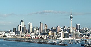
Auckland is a large metropolitan city in the North Island of New Zealand. The most populous urban area in the country and the fifth largest city in Oceania, Auckland has an urban population of about 1,440,300. It is located in the greater Auckland Region—the area governed by Auckland Council—which includes outlying rural areas and the islands of the Hauraki Gulf, and which has a total population of 1,695,200. While Europeans continue to make up the plurality of Auckland's population, the city became multicultural and cosmopolitan in the late-20th century, with Asians accounting for 31% of the city's population in 2018. Auckland is revealed as having the fourth largest foreign-born population in the world, with 39% of its residents born overseas. With its large population of Pasifika New Zealanders, the city is also home to the biggest ethnic Polynesian population in the world. The Māori-language name for Auckland is Tāmaki Makaurau, meaning "Tāmaki desired by many", in reference to the desirability of its natural resources and geography.

Zealandia, also known as Te Riu-a-Māui (Māori) or Tasmantis, is an almost entirely submerged mass of continental crust in Oceania that subsided after breaking away from Gondwanaland 83–79 million years ago. It has been described variously as a submerged continent, continental fragment, and microcontinent. The name and concept for Zealandia was proposed by Bruce Luyendyk in 1995, and satellite imagery shows it to be almost the size of Australia. A 2021 study suggests Zealandia is 1 billion years old, about twice as old as geologists previously thought.
Polynesia is a subregion of Oceania, made up of more than 1000 islands scattered over the central and southern Pacific Ocean. The indigenous people who inhabit the islands of Polynesia are called Polynesians. They have many things in common, including language relatedness, cultural practices, and traditional beliefs. In centuries past, they had a strong shared tradition of sailing and using stars to navigate at night. The largest country in Polynesia is New Zealand.
