Hollyford Track

Last updated

The start of the track at the Hollyford River. Start of Hollyford Track.jpg
The start of the track at the Hollyford River.

The Hollyford Track is a tramping track in New Zealand. Located at the northern edge of Fiordland, in the southwestern South Island, it is unusual among Fiordland's major tracks in that it is largely flat and accessible year-round. It follows the Hollyford River which in turn follows the course of the Hollyford Valley.

Contents

History

The Māori people were the first to settle the area around Martins Bay, though by the time of the arrival of Europeans in the mid-19th century, only a handful remained in the area. One of these was Tūtoko, for whom Mount Tūtoko, which rises 2700m above the Hollyford valley, was subsequently named.

he first Europeans to reach the bay via an inland route was Patrick Caples from Hollyford County Tipperary Ireland in 1863, although early runholders David McKellar and George Gunn had mapped some of the valley two years previously. Also in 1863, a small ship captained by a Captain Alabaster crossed the sandbar at Martins Bay to reach Lake McKerrow.

In the early days of European settlement, there was much enthusiasm for a commercial port at Martins Bay, led by the Otago Provincial Council. A settlement - Jamestown - was surveyed and several houses built, but the lack of road links to the rest of the province and the dangerous sandbar led to the gradual waning of the settlement, which was practically deserted by 1879, only some eleven years after its founding. Only one family, the McKenzies, remained close to Martins Bay. They sold their property to Davy Gunn in 1926. Gunn continued to farm the area, and also mapped the area and was a pioneer in the tramping tourism industry, taking parties of walkers along the valleys of the Hollyford, Pyke and Cascade Rivers. After his death in 1955, his son Murray continued to guide trampers in the area, and started "Gunn's Camp", a rest-stop for trampers with store and small museum, which still stands near the southern end of the track, around 10 km from the Milford Sound-Te Anau highway.

The gravel road was being constructed up until 1941 when the workers were taken off the job for the war effort and was worked on both ends. After World War II the idea of a road linking Haast to Hollyford was reignited to allow access and used prison and unemployed labor to progress the work. In 1960, the valley became part of Fiordland National Park and Davy Gunn's original tracks have since been upgraded and tramping huts established.

The track

The track is 56 kilometres (35 mi) in length. It runs in a roughly south–north direction, its southern end being accessible by road 15 kilometres to the east of the Homer Tunnel, and its northern end being at the Tasman Sea coast at Martins Bay, north of Milford Sound. [1]

For most of its path, the track follows the course of the Hollyford River / Hollyford Valley. Features of the track are the two lakes, Lake Alabaster (or Waiwahuika) and Lake McKerrow (or Whakatipu Waitai), the latter being a fiord now cut off from the sea by sediment. The track runs through lowland forest, with views of surrounding mountains. Wildlife visible from the track include seals, penguins, and herons.

The track is part of the Department of Conservation network with several bunk huts scattered along its length. It also has a guided operation operated by Ngai Tahu Tourism (owned by the main South Island Maori tribal group) with their own Lodges at Pyke and Martins Bay. The guided option combines hiking, jetboating and helicopter flights in a three-day journey from the mountains to the sea. Freedom walkers can make the walk more accessible by flying into or out of Martins Bay. Walkers are advised to be aware that the 2-3 day section from the Pyke River to Martins Bay alongside Lake McKerrow is well known as the 'Demon Trail'. This due to its uneven nature with multiple side streams. The Demon trail is aptly named and can be slippery in the wet.

Road proposals

There have been a number of proposals for a road in the vicinity of the track to link Haast with the Milford Sound road, proposed as early as the 1870s. [2]

In 2001 a widely distributed newspaper advertising supplement "The South Island Loop" promoted the Hollyford road as well as a road in the vicinity of the Heaphy Track. Mayors in the South Island and other supporters pushed for having the road built. [3] Forest and Bird, New Zealand's largest conservation organisation, called it the "biological equivalent of smashing the Mona Lisa". [4] In January 2010, the National-led government confirmed that it was considering a Hollyford road proposal. The Westland District Council and the owner of a hotel chain are backing plans for the road. [2] [5] The plans were however put on hold in March 2010, when government decided that the investment was a low priority. [6]

See also

Related Research Articles

<span class="mw-page-title-main">Fiordland</span> Geographical region of New Zealand

Fiordland is a geographical region of New Zealand in the south-western corner of the South Island, comprising the westernmost third of Southland. Most of Fiordland is dominated by the steep sides of the snow-capped Southern Alps, deep lakes, and its steep, glacier-carved and now ocean-flooded western valleys. The name "Fiordland" comes from a variant spelling of the Scandinavian word for this type of steep valley, "fjord". The area of Fiordland is dominated by, and very roughly coterminous with, Fiordland National Park, New Zealand's largest National Park.

<span class="mw-page-title-main">Fiordland National Park</span> National park on South Island of New Zealand

Fiordland National Park occupies the southwest corner of the South Island of New Zealand. It is by far the largest of the 13 national parks in New Zealand, with an area of 12,607 square kilometres (4,868 sq mi), and a major part of the Te Wahipounamu World Heritage Site. The park is administered by the Department of Conservation.

<span class="mw-page-title-main">Jackson Bay</span>

Jackson Bay / Okahu is a gently curving 24-kilometre (15 mi) bay on the southern West Coast of the South Island of New Zealand. It faces the Tasman Sea to the north, and is backed by the Southern Alps. It contains the settlements of Hannahs Clearing, Waiatoto, Neils Beach, and the fishing village of Jackson Bay at its western end. The bay is the southernmost terminus of the West Coast's roads.

<span class="mw-page-title-main">Mount Aspiring National Park</span> National park in New Zealand

Mount Aspiring National Park is in the Southern Alps of the South Island of New Zealand, north of Fiordland National Park, situated in Otago and Westland regions. The park forms part of the Te Wahipounamu World Heritage Site.
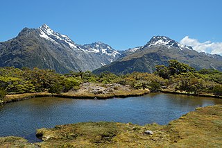
<span class="mw-page-title-main">Routeburn Track</span> Hiking track in New Zealand

The Routeburn Track is a world-renowned, 32 km tramping (hiking) track found in the South Island of New Zealand. The track can be done in either direction, starting on the Queenstown side of the Southern Alps / Kā Tiritiri o te Moana, at the northern end of Lake Wakatipu or on the Te Anau side, at the Divide, several kilometres from the Homer Tunnel to Milford Sound / Piopiotahi.

<span class="mw-page-title-main">Eglinton River</span> River in New Zealand

The Eglinton River is located in the region of Southland in the southwest of New Zealand. It flows through Fiordland National Park for 50 kilometres (31 mi). Its headwaters are at Lake Gunn, 25 kilometres (16 mi) east of Milford Sound, and it flows generally south before entering Lake Te Anau along the lake's eastern shore opposite the entrance to North Fiord.

<span class="mw-page-title-main">Hollyford River</span> River in New Zealand

The Hollyford River / Whakatipu Kā Tuka is in the southwest of the South Island of New Zealand. It runs for 72 kilometres (45 mi) through Fiordland, its sources being close to the Homer Tunnel and in Gertrude Valley in the southern Darran Mountains.

<span class="mw-page-title-main">Lake McKerrow</span>

Lake McKerrow lies at the northern end of Fiordland, in the southwest of New Zealand's South Island. The lake runs from southeast to northwest, is 15 kilometres (9 mi) in length, and covers 28 km2 (11 sq mi).

<span class="mw-page-title-main">Lake Alabaster</span> Lake in New Zealand

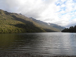
Lake Alabaster / Wāwāhi Waka, also known by the Māori name of Waiwahuika, lies at the northern end of Fiordland, in the southwest of New Zealand's South Island. The lake runs from northeast to southwest, is five kilometres (3.1 mi), and covers seven km2 (2.7 sq mi).

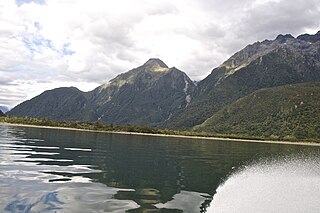
Lake Gunn is a lake in the South Island of New Zealand, located at 44°53′S168°05′E.

<span class="mw-page-title-main">Transport in Milford Sound</span>

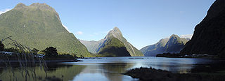
Transport in Milford Sound in New Zealand is characterised by the remoteness of the area in which it is located. As a popular tourism destination in the South Island, Milford Sound and the village of the same name receive very large numbers of visitors. These tend to arrive and depart within just a few hours each day, as there is little accommodation at the Sound, leading to strong demand peaks for tourism services during the noon and early afternoon period. The journey from Te Anau is rated as one of the most photographic drives of the world.

<span class="mw-page-title-main">Hollyford Valley</span> Valley in Southland Region, New Zealand

Hollyford Valley is a valley in Fiordland, New Zealand, in the southwest of the South Island. It is named for the Hollyford River, which runs north-north-west along its length from the Southern Alps to the Tasman Sea. Beech forest dominates both the slopes and the bottom of the valley.

<span class="mw-page-title-main">Lake Marian</span>

Lake Marian is an alpine lake at the southern end of the Darran Mountains in the Fiordland National Park in the South Island of New Zealand. The lake is located just above the treeline in a hanging valley leading northwest from the Hollyford Valley near The Divide pass. The valley is sheltered by steep snow-covered peaks of over 2,000 metres (6,600 ft) on all sides apart from the entrance.

<span class="mw-page-title-main">Humboldt Falls</span> Waterfall in Fiordland, New Zealand

Humboldt Falls is a waterfall located in the Hollyford Valley in the Fiordland district of New Zealand. They fall 275 metres in three drops; the largest of the three drops is 134 metres high.

<span class="mw-page-title-main">Mount Tūtoko</span> Mountain in Fiordland National Park, New Zealand

Mount Tūtoko is the highest peak in Fiordland National Park, in southwest New Zealand. It lies between the Hollyford Valley and Milford Sound, 15 kilometres due north of the Homer Tunnel at the northern end of the Darran Mountains. The glacier-covered mountain rises to a height of 2,723 metres (8,934 ft) and is visible from the Hollyford Track. Two slightly lower summits lie just to the south of the main peak.

<span class="mw-page-title-main">State Highway 94 (New Zealand)</span> Road in New Zealand

State Highway 94 is a New Zealand state highway connecting the large Southland town of Gore with one of New Zealand's most popular destinations, Milford Sound. It also passes the significant townships of Lumsden and Te Anau as well going through the Homer Tunnel. The road also goes through Fiordland and crosses the Main Divide of the Southern Alps.

David John Gunn was a New Zealander and promoter of the Hollyford Track. A farmer and bushman, he ran his almost wild cattle in the glacier-cut Hollyford Valley in Fiordland, South Westland, New Zealand.

<span class="mw-page-title-main">Haast-Hollyford road</span> Road in New Zealand

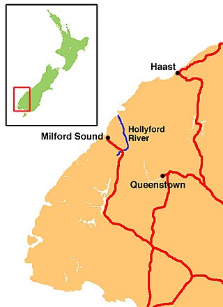
The Haast-Hollyford road or Haast-Hollyford Highway is a long-standing proposal to link Haast via the Hollyford Valley to Milford Sound and Te Anau in the South Island of New Zealand. Proposals for this road have been mooted since the 1880s.

<span class="mw-page-title-main">Humboldt Mountains (New Zealand)</span> Range of mountains in the Southern Alps of New Zealand

The Humboldt Mountains or Humboldt Range are one of the many ranges which make up the Southern Alps / Kā Tiritiri o te Moana in the South Island of New Zealand. They lie to the northwest of Lake Wakatipu in the Otago Region. Parts of the range lie within Fiordland National Park, and they form the southern extremity of Mount Aspiring National Park. The range was named by early explorer James McKerrow, and like many geographic features worldwide, it was named in honour of notable scientist Alexander von Humboldt.

Martins Bay is an indentation in the southwest coast of New Zealand's South Island. It lies immediately to the south of Big Bay and some 30 kilometres north of the mouth of Milford Sound at the northern tip of Fiordland. The Hollyford River reaches the Tasman Sea at Martins Bay.

References

  1. Hollyford (Map) (1st ed.). 335-03. Department of Survey and Land Information. 1988.
  2. 1 2 Cook, Marjorie (20 February 2010). "Highway through heritage". The New Zealand Herald . Retrieved 24 February 2010.
  3. Christian, Peter (3 April 2001). "SI mayors back roads push". The Press.
  4. "Road Proposals Similar To Smashing The Mona Lisa" (Press release). Forest and Bird. 11 April 2001.
  5. Cowlishaw, Shane (14 January 2010). "Hollyford road back before Govt". Southland Times. Retrieved 14 January 2010.
  6. "Haast to Milford road indefinitely on hold". The New Zealand Herald . 9 March 2010. Retrieved 8 March 2010.

Further reading

44°41′34″S168°07′33″E / 44.6928°S 168.1258°E / -44.6928; 168.1258