Southport is a seaside town in Merseyside, England.

Fiordland National Park occupies the southwest corner of the South Island of New Zealand. It is by far the largest of the 13 national parks in New Zealand, with an area of 12,607 square kilometres (4,868 sq mi), and a major part of the Te Wahipounamu World Heritage Site. The park is administered by the Department of Conservation.
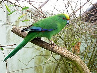
Cyanoramphus malherbi is a small parrot endemic to New Zealand, where it is known as the orange-fronted parakeet or orange-fronted kākāriki. In the rest of the world it is called Malherbe's parakeet, as when it was recognised as a species, the name "orange-fronted parakeet" was already used for Eupsittula canicularis, a Central American species. Restricted to a few valleys in the South Island and four offshore islands, its population declined to around 200 in the 1990s, and it is considered critically endangered.

West Cape is the westernmost point in the main chain of islands of New Zealand. It is located in the far southwest of the South Island, within Fiordland National Park, between Tamatea / Dusky Sound and Taiari / Chalky Inlet. The cape consists of a small rocky shore and low forest-covered sloping land, and is located just north of the Newton River mouth.
Chalky Island or Te Kākahu-o-Tamatea is an island in the southwest of New Zealand, and is part of Fiordland National Park. It lies at the entrance to Taiari / Chalky Inlet, next to Rakituma / Preservation Inlet, at the southwestern tip of the South Island, 10 kilometres (6 mi) northwest of Puysegur Point, 15 kilometres (9 mi) southeast of West Cape, and 140 kilometres (87 mi) west of Invercargill.

Rakituma / Preservation Inlet is the southernmost fiord in Fiordland National Park and lies on the southwest corner of the South Island of New Zealand. With an area of 93 square kilometres (36 sq mi), it is the fourth largest fiord in New Zealand, after Tamatea / Dusky Sound, Doubtful Sound / Patea, and the neighbouring Taiari / Chalky Inlet to the north. Rakituma was briefly the site of an attempted fishing and gold mining settlement at Cromarty during the 19th century, however this was quickly abandoned once the level of gold declined in relation to more promising fields elsewhere.
The following lists events that happened during 1827 in New Zealand.
The following lists events that happened during 1822 in New Zealand.
The Inner Little Goose Island, part of the Badger Group within the Furneaux Group, is a 4.5-hectare (11-acre) unpopulated small, round granite island, located in Bass Strait between Goose and Little Goose islands, lying west of the Flinders and Cape Barren islands, Tasmania, south of Victoria, in south-eastern Australia. The island is contained within a conservation area and is part of the Chalky, Big Green and Badger Island Groups Important Bird Area.
The Big Green Island, part of the Big Green Group within the Furneaux Group, is a 122-hectare (300-acre) granite island with limestone and dolerite outcrops, located in Bass Strait west of Flinders Island, in Tasmania, in south-eastern Australia. The island is partly contained within a nature reserve with the rest being used for farming; and is part of the Chalky, Big Green and Badger Island Groups Important Bird Area.
Chalky Island may refer to:
The Little Chalky Island, part of the Big Green Group within the Furneaux Group, is a 5-hectare (12-acre) unpopulated granite island, located in the Bass Strait, west of the Flinders Island and south of Chalky Island, in Tasmania, in south-eastern Australia. The island is part of the Chalky, Big Green and Badger Island Groups Important Bird Area.

The Chalky Island, part of the Big Green Group within the Furneaux Group, is a 41-hectare (100-acre) unpopulated granite island with limestone outcrops and dolerite dykes, located in the Bass Strait, west of the Flinders Island, in Tasmania, in south-eastern Australia. The island is contained within a conservation area and is part of the Chalky, Big Green and Badger Island Groups Important Bird Area.
The Isabella Island, part of the Big Green Group within the Furneaux Group, is a 11.4-hectare (28-acre) unpopulated granite island, located in the Bass Strait, west of the Flinders Island and south of Chalky Island, in Tasmania, in south-eastern Australia. The island is a nature reserve and is part of the Chalky, Big Green and Badger Island Groups Important Bird Area.

The Te Kakahu skink is a critically endangered species of skink native to New Zealand. When discovered, the entire species was inhabiting a single patch of clifftop vegetation on Chalky Island in Fiordland National Park.
The Mayor of Rangitikei is the head of the Rangitikei District Council in New Zealand. The role was created in 1989 with the formation of the Rangitikei District as part of the 1989 local government reforms. The current mayor since 2013 is Andy Watson from Marton.

Great Island is an island in the southwest of New Zealand, and is part of Fiordland National Park. It lies in Taiari / Chalky Inlet, north of Chalky Island and contains two small lakes, Lake Dobson and Lake Esau.
Chalky or Chalkie may refer to:
Taiari / Chalky Inlet is one of the southernmost fiords in Fiordland, in the southwestern corner of New Zealand's South Island and part of Fiordland National Park. As with the neighbouring fiords of Tamatea / Dusky Sound to the north and Rakituma / Preservation Inlet to the south, Taiari / Chalky Inlet is a complex fiord with many channels and islands along its roughly 28 km (17 mi) length. Most notably, this includes the sections Moana-whenua-pōuri / Edwardson Sound and Te Korowhakaunu / Kanáris Sound, which split at Divide Head in the middle of Taiari and each extend for roughly 10 km (6.2 mi) inland in a V-shape.
The Fiordland Islands restoration programme is run by the New Zealand Department of Conservation. The purpose of the programme is to eradicate pests on key islands around Fiordland National Park, once the islands are considered predator free endangered native species will be translocated to the islands.
