Breaksea Sound

Last updated

Te Puaitaha / Breaksea Sound
Te Puaitaha (Māori)
Te Puaitaha Breaksea Sound.jpg
Te Puaitaha / Breaksea Sound from the air
Breaksea Sound
NZ Fiordland relief location map.svg
Red pog.svg
Te Puaitaha / Breaksea Sound
Location in New Zealand
New Zealand (relief map).png
Disc Plain red.svg
Te Puaitaha / Breaksea Sound
Te Puaitaha / Breaksea Sound (New Zealand)
Location Tasman Sea
Coordinates 45°34′S166°47′E / 45.57°S 166.78°E / -45.57; 166.78
Basin  countries New Zealand
Max. width1 km (0.62 mi)

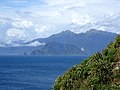
Te Puaitaha / Breaksea Sound is a small fiord on the southwestern coast of South Island, New Zealand in the Tasman Sea. Breaksea Island in Fiordland National Park lies at its entrance. In the 1850s, early settlers Henry Hirst and John Watts-Russell explored the area for flat land suitable for sheep farming, but they were unsuccessful. [1] In October 2019, the name of the fiord was officially altered to Te Puaitaha / Breaksea Sound. [2]

Related Research Articles

<span class="mw-page-title-main">Milford Sound</span> Fiord in the southwest of New Zealands South Island

Milford Sound is a fiord in the south west of New Zealand's South Island within Fiordland National Park, Piopiotahi Marine Reserve, and the Te Wahipounamu World Heritage site. It has been judged the world's top travel destination in an international survey and is acclaimed as New Zealand's most famous tourist destination. Rudyard Kipling called it the eighth Wonder of the World. The fiord is most commonly accessed via road by tour coach, with the road terminating at a small village also called Milford Sound.

<span class="mw-page-title-main">Fiordland</span> Geographical region of New Zealand

Fiordland is a geographical region of New Zealand in the south-western corner of the South Island, comprising the westernmost third of Southland. Most of Fiordland is dominated by the steep sides of the snow-capped Southern Alps, deep lakes, and its steep, glacier-carved and now ocean-flooded western valleys. The name "Fiordland" comes from a variant spelling of the Scandinavian word for this type of steep valley, "fjord". The area of Fiordland is dominated by, and very roughly coterminous with, Fiordland National Park, New Zealand's largest National Park.

<span class="mw-page-title-main">Fiordland National Park</span> National park on South Island of New Zealand

Fiordland National Park is a national park in the south-west corner of South Island of New Zealand. It is the largest of the 13 national parks in New Zealand, with an area covering 12,607 km2 (4,868 sq mi), and a major part of the Te Wāhipounamu a UNESCO World Heritage Site established in 1990. The park is administered by the Department of Conservation. The southern ranges of the Southern Alps cover most of Fiordland National Park, combined with the deep glacier-carved valleys.

<span class="mw-page-title-main">Doubtful Sound / Patea</span> Fiord in New Zealand

Doubtful Sound / Patea is a fiord in Fiordland, in the far south west of New Zealand. It is located in the same region as the smaller but more famous and accessible Milford Sound / Piopiotahi. It took second place after Milford Sound as New Zealand's most famous tourism destination.

<span class="mw-page-title-main">Lake Te Anau</span> Lake in the South Island of New Zealand

Lake Te Anau is in the southwestern corner of the South Island of New Zealand. The lake covers an area of 344 km2 (133 sq mi), making it the second-largest lake by surface area in New Zealand and the largest in the South Island. It is the second largest lake in Australasia by fresh water volume. The main body of the lake runs north-south, and is 65 km in length. Three large fiords form arms to the lake on its western flank: North Fiord, Middle Fiord and South Fiord. These are the only inland fiords that New Zealand has, the other 14 are out on the coast. Several small islands lie in the entrance to Middle Fiord, which forks partway along its length into northwest and southwest arms. The surface of the lake is at an altitude of 210 m. It has a maximum depth of 425 m, so much of its bed lies below sea level, with the deepest part of the lake being 215 metres below sea level.

<span class="mw-page-title-main">Resolution Island (New Zealand)</span> Island in New Zealands Fiordland region

Resolution Island or Tau Moana (Māori) is the largest island in the Fiordland region of southwest New Zealand, covering a total of 208 km2 (80 sq mi). It is the country's seventh largest island, and the second largest uninhabited island. Resolution Island is separated from the mainland of the South Island by Tamatea / Dusky Sound, Te Puaitaha / Breaksea Sound, and Acheron Passage. The island is part of the Fiordland National Park.

<span class="mw-page-title-main">Dusky Sound</span> Fiord on New Zealands South Island

Tamatea / Dusky Sound is a fiord on the southwest corner of New Zealand, in Fiordland National Park.

<span class="mw-page-title-main">Rakituma / Preservation Inlet</span> Fiord in the South Island of New Zealand

Rakituma / Preservation Inlet is the southernmost fiord in Fiordland National Park and lies on the southwest corner of the South Island of New Zealand. With an area of 93 square kilometres (36 sq mi), it is the fourth largest fiord in New Zealand, after Tamatea / Dusky Sound, Doubtful Sound / Patea, and the neighbouring Taiari / Chalky Inlet to the north. Rakituma was briefly the site of an attempted fishing and gold mining settlement at Cromarty during the 19th century, however this was quickly abandoned once the level of gold declined in relation to more promising fields elsewhere.

<span class="mw-page-title-main">Breaksea Island (Fiordland)</span> Island in New Zealand

Breaksea Island is a rugged 1.6 km2 (1 sq mi) island in the southwest of New Zealand, and is part of Fiordland National Park. Its highest point is 350 m (1,148 ft) asl and it lies about 2 km (1.2 mi) from the mainland in the entrance to Te Puaitaha / Breaksea Sound, north of the much larger Resolution Island. It is covered in temperate rainforest and was the site of one of the first successful campaigns to eradicate rats from a sizeable island.

Hāwea / Bligh Sound is a fiord of the South Island of New Zealand. It is located in Fiordland, 30 kilometres southwest of Milford Sound, and is 15 kilometres in length. The fiord forms a crooked "Z" shape. Wild Natives River flows into the innermost arm, Bounty Haven.

Te Rā / Dagg Sound is a narrow fiord located in Fiordland, New Zealand. It lies south of Doubtful Sound / Patea and north of Te Puaitaha / Breaksea Sound. Whales frequent the waters out from the entrance of the fiord, close to the edge of the continental shelf where the water depth suddenly drops to thousands of metres.

Sutherland Sound is a fiord of the South Island of New Zealand. It is the smallest of the fiords that make up the coast of Fiordland, and the only one with limited sea access. It is the second most northerly of the fiords, 22 kilometres southwest of Milford Sound / Piopiotahi and eight kilometres northeast of Hāwea / Bligh Sound. The fiord is ten kilometres in length and the Light River and the Dark River flow into the eastern end. The fiord is composed of two main sections - a large bay opening into the sea, and a more traditional fiord as the inner section. These are separated by a narrow channel less than 100 metres (330 ft) wide at its narrowest point.

Thompson Sound is a fiord of the South Island of New Zealand. It is one of the fiords that form the coast of Fiordland.

<span class="mw-page-title-main">Charles Sound</span> Fiord of the South Island of New Zealand

Charles Sound is a fiord of the South Island of New Zealand. It is one of the fiords that form the coast of Fiordland.

Taitetimu / Caswell Sound is a fiord of the South Island of New Zealand. It is one of the fiords that form the coast of Fiordland.

Te Houhou / George Sound is a fiord of the South Island of New Zealand. It is one of the fiords that form the coast of Fiordland.

Hinenui / Nancy Sound is a fiord on the South Island of New Zealand. It is one of the fiords that form the coast of Fiordland.

Taiari / Chalky Inlet is one of the southernmost fiords in Fiordland, in the southwestern corner of New Zealand's South Island and part of Fiordland National Park. As with the neighbouring fiords of Tamatea / Dusky Sound to the north and Rakituma / Preservation Inlet to the south, Taiari / Chalky Inlet is a complex fiord with many channels and islands along its roughly 28 km (17 mi) length. Most notably, this includes the sections Moana-whenua-pōuri / Edwardson Sound and Te Korowhakaunu / Kanáris Sound, which split at Divide Head in the middle of Taiari and each extend for roughly 10 km (6.2 mi) inland in a V-shape.

Te Hapua Marine Reserve is a marine reserve covering an area of 449 hectares of Te Hāpua / Sutherland Sound, in Fiordland on New Zealand's South Island. It was established in 2005 and is administered by the Department of Conservation.

References

  1. "Obituary". The Press . Vol. LXVII, no. 14233. 22 December 1911. p. 7. Retrieved 24 August 2016.
  2. "NZGB notices – October 2019". Land Information New Zealand. 17 October 2019. Retrieved 15 December 2019.