Related Research Articles

The Tasman Sea is a marginal sea of the South Pacific Ocean, situated between Australia and New Zealand. It measures about 2,000 km (1,200 mi) across and about 2,800 km (1,700 mi) from north to south. The sea was named after the Dutch explorer Abel Janszoon Tasman, who in 1642 was the first known person to cross it. British explorer Lieutenant James Cook later extensively navigated the Tasman Sea in the 1770s during his three voyages of exploration.
The Dominion Range is a broad mountain range, about 30 nautical miles long, forming a prominent salient at the juncture of the Beardmore and Mill glaciers in Antarctica. The range is part of the Queen Maud Mountains The range was discovered by the British Antarctic Expedition, 1907–09 and named by Ernest Shackleton for the Dominion of New Zealand, which generously aided the expedition.
Mount Bird is a 1,765 metres (5,791 ft) high shield volcano standing about 7 nautical miles south of Cape Bird, the northern extremity of Ross Island. It was mapped by the British National Antarctic Expedition, 1901–04, under Robert Falcon Scott, and apparently named by them after Cape Bird.
The Carrick River is a river of Fiordland, close to the southwesternmost point of New Zealand's South Island. Its course is predominantly southward, and passes through numerous small lakes, most notably Lake Victor, before reaching the sea at the Islet Cove of Te Korowhakaunu / Kanáris Sound.
The Coal River is a river of Fiordland, New Zealand. It rises south of Stephens Peak and flows south-westward into the Tasman Sea, draining Lakes Beattie, Swan and Paradise.
The Edison River is a river of the Westland District of New Zealand. It arises in the Solution Range near Mount Elliot and flows north-west and north into the Mahitahi River.
The Kaniere River is a river of New Zealand. It is located in the West Coast Region of the South Island. The river is the outflow of Lake Kaniere, and flows west to reach the Hokitika River five kilometres from the coast of the Tasman Sea.
The Lambert River is a river of the West Coast Region of New Zealand's South Island. It flows north from the Lambert Glacier in the Southern Alps, joining with the Wanganui River 15 kilometres (9 mi) southeast of Harihari.
The Mike River is a river in Fiordland, New Zealand. It rises near Staircase Saddle and drains a number of small lakes, among them Lake Mike and False Lake, into Dusky Sound at Fanny Bay.
The Namu River is a river in Fiordland, New Zealand. It rises north of Mount Namu and flows westward into Open Cove, Te Awa-o-Tū / Thompson Sound.

The Newton River is a river in Fiordland, New Zealand. It drains Lake Fraser south-westward into the Tasman Sea just south of West Cape.
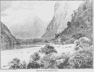
The Seaforth River is a river in New Zealand, flowing into Dusky Sound. About 9 km (5.6 mi) and 41 m (135 ft) up from Supper Cove in Dusky Sound is Lake Maree. The river rises about another 20 km (12 mi) to the north, on the slopes of the Black Giants, at about 1,300 m (4,300 ft). Like many former British Empire locations, it and its lakes have Scottish names.
The Wilson River, New Zealand is a river in southern Fiordland, New Zealand. It flows into the Tasman Sea 5 kilometres (3 mi) south-east of Puysegur Point.
The Meyer Desert is a triangular ice-free area of about 50 square miles (130 km2) at the northern end of the Dominion Range, Antarctica, near the confluence of Beardmore Glacier and Mill Glacier. It was named by the New Zealand Geological Survey Antarctic Expedition of 1961–62 for George Meyer of the United States Antarctic Research Program, who was scientific leader at McMurdo Station in 1961, and led a field party into this area in the summer of 1961–62.
The Taipo River is a river of the central West Coast Region of New Zealand's South Island. It flows north from its sources west of Mount Rolleston, fed by the waters of several mountain streams. After some 15 kilometres it turns northeast to flow past the Bald Range before reaching the valley of the Taramakau River into which it flows 35 kilometres east of Hokitika.

Pandora is a fictional character appearing in American comic books published by DC Comics. She is based on Pandora of Greek mythology.

MV Kaitawa was a 2,485-ton collier owned by the Union Steamship Company. She was lost with all hands on 24 May 1966 near Cape Reinga, New Zealand.
Mount Grono, previously spelled Mount Groznoz, is a 1,196-metre (3,924 ft) peak on Secretary Island, part of New Zealand's Fiordland National Park. It was named for early 19th century sealer John Grono.
Shag River is a river on Resolution Island in Fiordland, New Zealand. It rises north west of Mount Roa and flows south into the Taumoana Marine Reserve, part of Tamatea / Dusky Sound.
References
- ↑ "Place name detail: Pandora River". New Zealand Gazetteer. New Zealand Geographic Board . Retrieved 23 April 2010.
45°10′25″S166°59′12″E / 45.173661°S 166.986578°E