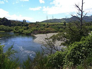
The Manuherikia River is located in Otago in the South Island of New Zealand. It rises in the far north of the Maniototo, with the West Branch draining the eastern side of the St Bathans Range, and the East Branch draining the western flanks of the Hawkdun Range. The river continues southwest through the wide Manuherikia Valley to its confluence with the Clutha River at Alexandra. During the 1860s the Manuherikia was one of the centres of the Central Otago Gold Rush.
Tucker Glacier is a major valley glacier of Victoria Land, Antarctica, about 90 nautical miles long, flowing southeast between the Admiralty Mountains and the Victory Mountains to the Ross Sea. There is a snow saddle at the glacier's head, just west of Homerun Range, from which the Ebbe Glacier flows northwestward.
Wheatstone is a locality in the Canterbury region of New Zealand's South Island. It is located on the Canterbury Plains south of Ashburton, on the banks of the Ashburton River / Hakatere. Other nearby settlements include Huntingdon to the north, Eiffelton and Flemington to the west, Ashton and Waterton to the south, and Riverside and Wakanui to the east on the opposite side of the Ashburton River / Hakatere. Wheatstone is slightly inland from the coastline of the Pacific Ocean.

The Mararoa River is one of the braided rivers of the Southland Region of the South Island of New Zealand.
The Doon River is a river in Fiordland, in the Southland Region of New Zealand. It arises near Mount Donald and flows south-east into the south-west arm of Lake Te Anau.
The Elizabeth River, New Zealand is a river of Fiordland, New Zealand. It rises north of Mount George and flows westward through Fiordland National Park into the Malaspina Reach of Doubtful Sound at Olphert Cove. Elizabeth Island is in the Reach by the river mouth. The river and island were named by Captain John Grono after his brig Elizabeth in late 1822 or early 1823.
The Juno River is a river of Fiordland, New Zealand. It rises west of Lake Shirley and flows westward into the Tasman Sea between Taitetimu / Caswell Sound and Taiporoporo / Charles Sound.
The Kaniere River is a river of New Zealand. It is located in the West Coast Region of the South Island. The river is the outflow of Lake Kaniere, and flows west to reach the Hokitika River five kilometres from the coast of the Tasman Sea.

The Kokatahi River is a river of the West Coast Region of New Zealand's South Island. A major tributary of the Hokitika River, it flows northwest from its origins on the northern slopes of Mount Ambrose, reaching the Hokitika River 12 kilometres from the latter's mouth at Hokitika. The two rivers between them share one of the West Coast's larger floodplains.
The Misty River is a river in Fiordland, New Zealand. It rises to the east of Irene Pass and flows westward into Teardrop Lake and on to Kaikiekie / Bradshaw Sound.

The Monowai River is a river in New Zealand, draining Lake Monowai into the Waiau River and feeding the Monowai Power Station.
The Rea River is a river in Fiordland, New Zealand. It rises west of Teardrop Lake and flows into Misty River before it enters Kaikiekie / Bradshaw Sound.
The Smite River is a river of the Canterbury region of New Zealand's South Island. It flows west from the Taylor Range to feed Lake Stream, the outflow of Lake Heron, which is an upper part of the Rakaia River system.
The Te Rahotaiepa River is a river of the West Coast Region of New Zealand's South Island. It rises to the north of Lake Ianthe and flows parallel with the Tasman Sea coast along the edge of marshy ground for several kilometres to flow into the mouth of the Waitaha River.

The Tuke River is a river of the West Coast Region of New Zealand's South Island. It flows northwest from the Southern Alps, combining with the Dickson River to form the Mikonui River 15 kilometres southeast of Ross.
The Upukerora River is a river in New Zealand, flowing into Lake Te Anau north of Te Anau township.
The Whakaikai River is a short river of the West Coast Region of New Zealand's South Island. It flows generally northwest to reach the Tasman Sea five kilometres to the northwest of the mouth of the Wanganui River.

The Whitcombe River is a river of the West Coast Region of New Zealand's South Island. It flows north to reach the Hokitika River 30 kilometres south of Hokitika.
The Spey River is a river in the Southland Region of New Zealand. Its entire length lies within the Fiordland National Park. The Spey rises at the Mckenzie Pass and Murrell's Pass either side of Mt Horatio (1,380 metres, and the river flows in a northeasterly direction, emptying into the West Arm of Lake Manapouri adjacent to the intake of the Manapouri Power Station. The Dusky Track follows the Spey valley for much of the river's length.


