
Franklin District was a New Zealand territorial authority that lay between the Auckland metropolitan area and the Waikato Plains. As a formal territory, it was abolished on 31 October 2010 and divided between Auckland Council in the Auckland Region to the north and Waikato and Hauraki districts in the Waikato region to the south and east. The Auckland portion is now part of the Franklin Ward, which also includes rural parts of the former Manukau City.

Karamea is a town on the West Coast of the South Island of New Zealand. It is the northernmost settlement of any real size on the West Coast, and is located 96 kilometres (60 mi) northeast by road from Westport. Apart from a narrow coastal strip, the town of Karamea and its local area are completely surrounded to the south, east and north by Kahurangi National Park.

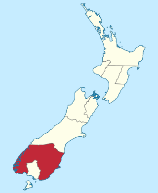
The Catlins comprises an area in the southeastern corner of the South Island of New Zealand. The area lies between Balclutha and Invercargill, straddling the boundary between the Otago and Southland regions. It includes the South Island's southernmost point, Slope Point.

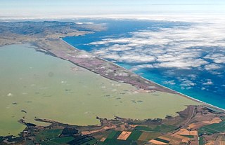
The Awarua Plain is a large area of wetland to the east of Bluff, New Zealand. Covering an area of around 600 km², the plain stretches for 35 kilometres along the coast of Foveaux Strait. This stretch of coast includes the peninsula of Tiwai Point, Awarua Bay, the Waituna Lagoon, and Toetoes Bay. The Mataura River is the major river responsible for the presence of the Awarua Plain; along with the Ōreti River, it is a remnant of the rivers from the Ice Ages that formed the Southland Plains (Murihiku). In addition, several small streams enter Foveaux Strait along this stretch of coast, mainly via Awarua Bay and Waituna Lagoon.

Toetoes Bay is the easternmost of three large bays lying on the Foveaux Strait coast of Southland, New Zealand, the others being Te Waewae Bay and Oreti Beach. The 240 km Mataura River drains to sea at Toetoes Bay, first passing through the Toetoes Harbour estuary. Thirty kilometres in length, the bay is the southern end of the Awarua Plain, an area of swampy land stretching inland for about fifteen kilometres. The eastern end of the bay is close to Slope Point, the South Island's southernmost point, and the western end of the Catlins.
Awarua Point is located on the southwestern coast of New Zealand's South Island, at the northern end of Big Bay, 40 kilometres (25 mi) north of Milford Sound / Piopiotahi, and 15 kilometres (9.3 mi) north of the mouth of the Hollyford River / Whakatipu Kā Tuka.

Te Awarua-o-Porirua Harbour, commonly known as Porirua Harbour, is a natural inlet in the south-western coast of the North Island of New Zealand.

Overstrand Municipality is a local municipality in the Western Cape province of South Africa. It is located along the Atlantic coast between Cape Town and Cape Agulhas, within the Overberg District Municipality. The principal towns in the municipality are Hermanus, Gansbaai and Kleinmond. As of 2011, it had a population of 80,432.

Westland District is a territorial authority district on the West Coast of New Zealand's South Island. It is administered by the Westland District Council. The district's population is 8,940.

The Hibiscus Coast is a populated area on a stretch of the Hauraki Gulf coast in New Zealand's Auckland Region. It has a population of 64,660, making it the 10th most populous urban area in New Zealand, and the second most populous in the Auckland Region, behind Auckland itself. As an urban area delineated by Statistics New Zealand, the Hibiscus Coast consists of Hatfields Beach, Orewa, Silverdale and Whangaparāoa Peninsula. The Auckland Council's Hibiscus Coast subdivision of the Hibiscus and Bays includes the neighbouring communities of Waiwera and Stillwater, and Milldale in Rodney, is also described as a part of the Hibiscus Coast.
The Otago Province was a province of New Zealand until the abolition of provincial government in 1876. The capital of the province was Dunedin. Southland Province split from Otago in 1861, but became part of the province again in 1870.
The Dry Awarua River is a river of northern Fiordland, New Zealand. It rises in the McKenzie Range and flows south and then westward into the Waiuna Lagoon. The Lagoon then discharges into the Awarua River, which flows into Big Bay, also known as Awarua Bay. The Pyke - Big Bay tramping track crosses the Dry Awarua River.
Big Bay, also known as Awarua Bay, is a deep indentation in the southwestern coast of New Zealand's South Island, 40 kilometres north of Milford Sound and immediately to the north of Martins Bay. The bay is eight kilometres in width, and extends eight kilometres into the South Island, making an almost square indentation in the island's coastline. Its northern end is Awarua Point. Immediately beyond Long Reef, the rocky point at the southern end, is the mouth of the Hollyford River and Martins Bay. Big Bay has a sandy beach named Three Mile Beach. The Awarua River enters the bay at the northern end of the beach.

Ahuriri Lagoon was a large tidal lagoon at Napier, on the east coast of New Zealand's North Island, that largely drained when the area was raised by the 1931 Hawke's Bay earthquake.

A hapua is a river-mouth lagoon on a mixed sand and gravel (MSG) beach, formed at the river-coast interface where a typically braided, although sometimes meandering, river interacts with a coastal environment that is significantly affected by longshore drift. The lagoons which form on the MSG coastlines are common on the east coast of the South Island of New Zealand and have long been referred to as hapua by Māori people. This classification differentiates hapua from similar lagoons located on the New Zealand coast termed waituna.
Hawksbury Lagoon is situated within the East Otago town of Waikouaiti, on the northern boundary of Dunedin City, New Zealand.

Northern Pegasus Bay is a regional park in the northern part of Canterbury's Pegasus Bay in New Zealand's South Island. It is operated by Environment Canterbury.
Waiuna Lagoon is a lake in the Southland Region of New Zealand's South Island, just inland from Big Bay. It is 15 metres above sea level, and is drained by the Awarua River.
A waituna is a freshwater coastal lagoon on a mixed sand and gravel (MSG) beach, formed where a braided river meets a coastline affected by longshore drift. This type of waterbody is neither a true lake, lagoon nor estuary.

Ōtūmahana Estuary, also known as the Karamea Estuary, is a tidal estuary in the Buller District of the West Coast Region of New Zealand. It is located at the mouth of the Karamea River and also receives the outflow of Ōtūmahana creek.


