
The Lane Cove National Park is a protected national park that is located within metropolitan Sydney, in New South Wales, Australia. The 670-hectare (1,700-acre) national park is situated about 10 kilometres (6.2 mi) north-west of the Sydney central business district and features various vegetation types, such as, wet and dry sclerophyll forest, heathland, mangroves and tidal flats. The park consists of land near the banks of the Lane Cove River, which flows generally south-east into Sydney Harbour. It also extends to the outskirts of Pennant Hills and Wahroonga at its northern boundaries.

The Lane Cove River, a northern tributary of the Parramatta River, is a tide-dominated, drowned valley estuary west of Sydney Harbour, located in Sydney, New South Wales, Australia. The river winds through a bushland valley and joins Parramatta River at Greenwich and Woolwich, where together they form an arm of Sydney Harbour, and serves as a border along with Middle Harbour separating Sydney's North Shore.

Lane Cove is a suburb on the Lower North Shore of Sydney, New South Wales, Australia. Lane Cove is nine kilometres north-west of the Sydney central business district and is the administrative centre for the local government area of the Lane Cove Council. Lane Cove West and Lane Cove North are separate suburbs.
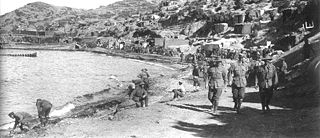
Anzac Cove is a small cove on the Gallipoli peninsula in Turkey. It became famous as the site of World War I landing of the ANZACs on 25 April 1915. The cove is 600 metres (2,000 ft) long, bounded by the headlands of Arıburnu to the north and Little Arıburnu, known as Hell Spit, to the south. Following the landing at Anzac Cove, the beach became the main base for the Australian and New Zealand troops for the eight months of the Gallipoli campaign.

Tamatea / Dusky Sound is a fiord on the southwest corner of New Zealand, in Fiordland National Park.

Farm Cove is a suburb located in East Auckland, New Zealand. The suburb is in the Howick ward, one of the thirteen administrative divisions of Auckland. The Rotary Walkway Reserve runs through Farm Cove.

Te Whanganui-A-Hei Marine Reserve is in the southern part of Mercury Bay on the Coromandel Peninsula in New Zealand covering an area of 840 hectares. On the coast of the mainland, it stretches from Cook Bluff in the north-west to the northern end of Hahei Beach in the south-east. Its offshore extremes run from Motukorure Island through Waikaranga Island to Okorotere Island and the northern end of Mahurangi Island.
The Abel Tasman Coast Track is a 60 kilometres (37 mi) long walking track within the Abel Tasman National Park in New Zealand. It extends from Mārahau in the south to Wainui in the north, with many side tracks. It is one of two main tracks through the park, the other being the Abel Tasman Inland Track, which stretches for 38 km between Tinline Bay and Torrent Bay off the main coastal track. The coastal track is well sheltered, and with mild weather in all seasons, it is accessible and open throughout the year.

Hahei is a small settlement in Mercury Bay on the eastern side of the Coromandel Peninsula in New Zealand. It is near Cathedral Cove, between the settlements of Cooks Beach and Hot Water Beach. It is approximately 11 km south east of Whitianga and 8 km north of Hot Water Beach.

Meretoto / Ship Cove is a small bay in the Marlborough Region of New Zealand, renowned as the first place of prolonged contact between Māori and Europeans. It is located near the entrance of Queen Charlotte Sound / Tōtaranui, west of nearby Motuara Island and Long Island.

Deep Cove is an arm of Doubtful Sound, a deep indentation in the southwest coast of New Zealand's South Island. Along with the Hall Arm, which lies to the southwest of Deep Cove, it forms one of the two most remote parts of the sound from the Tasman Sea, with its mouth being 32 kilometres (20 mi) from the mouth of Doubtful Sound. Elizabeth Island lies close to the junction of Deep Cove and the Hall Arm. Deep Cove by itself is about four kilometres long and is home to several waterfalls, including Helena Falls and Lady Alice Falls.
The Wilmot Pass is a 671 m (2,201 ft) high pass on the main divide of New Zealand's South Island. It connects Doubtful Sound, a deep indentation in the coast of Fiordland, to the valley of the West Arm of Lake Manapouri. The pass is named after E. H. Wilmot, a former surveyor-general of New Zealand, who had noted it while surveying the area in 1897. It lies between Mount Wilmot and Mount Mainwaring. On the east side the Spey River drains to Lake Manapouri and on the west side the Lyvia River drains to Deep Cove.

Kaikiekie / Bradshaw Sound is one of the larger New Zealand fiords. It is one of the sub fiords/arms that make up the Doubtful Sound/Thompson Sound complex and forms the northernmost of the blind or dead end fiords in this system.
The Buller River is a river in the Mid West region of Western Australia, near Geraldton.

Pasión de Amor is a 2015 Philippine romantic drama television series based on the 2003 Colombian telenovela Pasión de Gavilanes starring Mario Cimarro, Danna García, Juan Alfonso Baptista, Paola Rey, Michel Brown and Natasha Klauss, produced by Telemundo Internacional and R.T.I. Colombia. Directed by Eric Quizon, it is topbilled by Jake Cuenca, Arci Muñoz, Ejay Falcon, Ellen Adarna, Joseph Marco, Coleen Garcia are the main protagonists, while Wendell Ramos, Teresa Loyzaga and Dante Ponce are the main antagonists of the series. The series premiered on ABS-CBN's Primetime Bida evening block and worldwide on The Filipino Channel from June 1, 2015 to February 26, 2016, replacing Inday Bote and was replaced by We Will Survive.
Thompson Sound is a fiord of the South Island of New Zealand. It is one of the fiords that form the coast of Fiordland.
Te Houhou / George Sound is a fiord of the South Island of New Zealand. It is one of the fiords that form the coast of Fiordland.
Hinenui / Nancy Sound is a fiord on the South Island of New Zealand. It is one of the fiords that form the coast of Fiordland.

Ulva Island-Te Wharawhara Marine Reserve is a marine reserve covering an area of 1,075 hectares south-west and north-east of Ulva Island, in the Paterson Inlet of New Zealand's Stewart Island. It was established in 2004 and is administered by the Department of Conservation.


