Fiordland, is a non-administrative geographical region of New Zealand in the south-western corner of the South Island, comprising the western third of Southland. Most of Fiordland is dominated by the steep sides of the snow-capped Southern Alps, deep lakes, and its steep, glacier-carved and now ocean-flooded western valleys. The name "Fiordland" derives from an alternate spelling of the Scandinavian word for steep glacial valleys, "fjord". The geographic area of Fiordland is dominated by, and roughly coterminous with, Fiordland National Park, New Zealand's largest national park.

Fiordland National Park is a national park in the south-west corner of South Island of New Zealand. It is the largest of the 13 national parks in New Zealand, with an area covering 12,607 km2 (4,868 sq mi), and a major part of the Te Wāhipounamu a UNESCO World Heritage Site established in 1990. The park is administered by the Department of Conservation. The southern ranges of the Southern Alps cover most of Fiordland National Park, combined with the deep glacier-carved valleys.

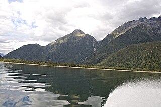
Lake Wakatipu is an inland lake in the South Island of New Zealand. It is in the southwest corner of the Otago region, near its boundary with Southland. Lake Wakatipu comes from the original Māori name Whakatipu wai-māori.
The Routeburn Track is a 32 km tramping (hiking) track found in the South Island of New Zealand. The track can be done in either direction, starting on the Queenstown side of the Southern Alps, at the northern end of Lake Wakatipu or on the Te Anau side, at the Divide, several kilometres from the Homer Tunnel to Milford Sound.
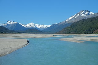
The Dart River flows through rugged forested country in the southwestern South Island of New Zealand. Partly in Mount Aspiring National Park, it flows south-west and then south for 60 kilometres (37 mi) from its headwaters in the Southern Alps and the Dart Glacier, eventually flowing into the northern end of Lake Wakatipu near Glenorchy.

The Hollyford River / Whakatipu Kā Tuka is in the southwest of the South Island of New Zealand. It runs for 72 kilometres (45 mi) through Fiordland, its sources being close to the Homer Tunnel and in Gertrude Valley in the southern Darran Mountains.

The Hollyford Track is a tramping track in New Zealand. Located at the northern edge of Fiordland, in the southwestern South Island, it is unusual among Fiordland's major tracks in that it is largely flat and accessible year-round. It follows the Hollyford River which in turn follows the course of the Hollyford Valley.
Lake McKerrow lies at the northern end of Fiordland, in the southwest of New Zealand's South Island. The lake runs from southeast to northwest, is 15 kilometres (9 mi) in length, and covers 28 km2 (11 sq mi).
Lake Alabaster / Wāwāhi Waka, also known by the Māori name of Waiwahuika, lies at the northern end of Fiordland, in the southwest of New Zealand's South Island. The lake runs from northeast to southwest, is five kilometres (3.1 mi), and covers seven km2 (2.7 sq mi).
Awarua Point is located on the southwestern coast of New Zealand's South Island, at the northern end of Big Bay, 40 kilometres (25 mi) north of Milford Sound / Piopiotahi, and 15 kilometres (9.3 mi) north of the mouth of the Hollyford River / Whakatipu Kā Tuka.
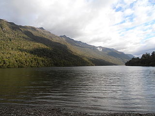
Lake Gunn is a lake in the South Island of New Zealand, located at 44°53′S168°05′E.

Hollyford Valley is a valley in Fiordland, New Zealand, in the southwest of the South Island. It is named for the Hollyford River, which runs north-north-west along its length from the Southern Alps to the Tasman Sea. Beech forest dominates both the slopes and the bottom of the valley.

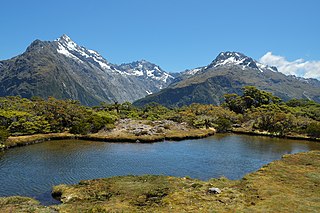
Lake Marian is an alpine lake at the southern end of the Darran Mountains in the Fiordland National Park in the South Island of New Zealand. The lake is located just above the treeline in a hanging valley leading northwest from the Hollyford Valley near The Divide pass. The valley is sheltered by steep snow-covered peaks of over 2,000 metres (6,600 ft) on all sides apart from the entrance.

Mount Tūtoko is the highest peak in Fiordland National Park, in southwest New Zealand. It lies between the Hollyford Valley and Milford Sound, 15 kilometres due north of the Homer Tunnel at the northern end of the Darran Mountains. The glacier-covered mountain rises to a height of 2,723 metres (8,934 ft) and is visible from the Hollyford Track. Two slightly lower summits lie just to the south of the main peak.

State Highway 94 is a New Zealand state highway connecting the large Southland town of Gore with one of New Zealand's most popular destinations, Milford Sound. It also passes the significant townships of Lumsden and Te Anau as well going through the Homer Tunnel. The road also goes through Fiordland and crosses the Main Divide of the Southern Alps.

The Greenstone River is a river in the Otago Region of New Zealand. It arises as the McKellar Branch in the Ailsa Mountains and as the Pass Burn in the Thomson Mountains, and joins the Caples River to flow into upper Lake Wakatipu. It is probably named because greenstone was found in the area. The Greenstone Track follows the river north along the McKellar Branch to Lake McKellar, joining the Hollyford Track. Another track follows the Pass Burn and reaches North Mavora Lake.

The Haast-Hollyford road or Haast-Hollyford Highway is a long-standing proposal to link Haast via the Hollyford Valley to Milford Sound and Te Anau in the South Island of New Zealand. Proposals for this road have been mooted since the 1880s.

The Humboldt Mountains or Humboldt Range are one of the many ranges which make up the Southern Alps / Kā Tiritiri o te Moana in the South Island of New Zealand. They lie to the northwest of Lake Wakatipu in the Otago Region. Parts of the range lie within Fiordland National Park, and they form the southern extremity of Mount Aspiring National Park. The range was named by early explorer James McKerrow, and like many geographic features worldwide, it was named in honour of notable scientist Alexander von Humboldt.

The Olivine Ice Plateau is a glacier in the Olivine Wilderness Area and Aspiring National Park in New Zealand's South Island. The plateau is named after the mineral olivine, which is common within the Dun Mountain Ophiolite that underlies the area. The plateau extents to the west over the Forgotten River Col. into the Forgotten River and to the north it merges with the Andy Glacier, which feeds a tributary of the Arawhata River. The Olivine Ice Plateau is one of many glaciers in the region of the Arawhata, Dart / Te Awa Whakatipu, Hollyford / Whakatipu Kā Tuka and Matukituki rivers' headwaters.
The Darran Mountains are a prominent range within New Zealand's Fiordland National Park, the country's biggest national park. They contain the park's highest peak, Mount Tūtoko.