
Aoraki / Mount Cook National Park is a national park located in the Canterbury Region in the central-west of the South Island of New Zealand. It was established in October 1953 and takes its name from the highest mountain in New Zealand, Aoraki / Mount Cook. The area of the park is 707 km2 (273 sq mi), and it shares a border with Westland Tai Poutini National Park along the Main Divide of the Southern Alps. The national park consists of reserves that were established as early as 1885 to protect the area's significant landscape and vegetation. Glaciers cover 40% of the park, including the county's largest glacier, Haupapa / Tasman Glacier. In 1990, the park was included in the area designated as the Te Wāhipounamu World Heritage Site. The park is managed by the Department of Conservation (DOC) alongside Ngāi Tahu, the iwi who are mana whenua in the region.

Jackson Bay / Okahu is a gently curving 24-kilometre (15 mi) bay on the southern West Coast of the South Island of New Zealand. It faces the Tasman Sea to the north, and is backed by the Southern Alps. It contains the settlements of Hannahs Clearing, Waiatoto, Neils Beach, and the fishing village of Jackson Bay at its western end. The bay is the southernmost terminus of the West Coast's roads.

Baron Sir Ferdinand Jacob Heinrich von Mueller, was a German-Australian physician, geographer, and most notably, a botanist. He was appointed government botanist for the then colony of Victoria, Australia by Governor Charles La Trobe in 1853, and later director of the Royal Botanic Gardens in Melbourne. He also founded the National Herbarium of Victoria. He named many Australian plants.

Tasman Glacier is the largest glacier in New Zealand, and one of several large glaciers which flow south and east towards the Mackenzie Basin from the Southern Alps in New Zealand's South Island.

Ōkārito Lagoon is a coastal lagoon on the West Coast of New Zealand's South Island. It is located 130 kilometres (81 mi) south of Hokitika, and covers an area of about 3,240 hectares (12.5 sq mi), making it the largest unmodified coastal wetland in New Zealand. It preserves a sequence of vegetation types from mature rimu forest through mānuka scrub to brackish water that has been lost in much of the rest of the West Coast. The settlement of Ōkārito is at the southern end of the lagoon.

The Tasman River is an alpine braided river flowing through Canterbury, in New Zealand's South Island.

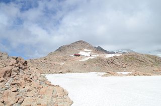
The Mueller Glacier is a 13-kilometre (8.1 mi) long glacier flowing through Aoraki / Mount Cook National Park in the South Island of New Zealand. It lies to the west of Mount Cook Village within the Southern Alps, flowing roughly north-west from its névé near Mount Montgomerie before curving around the Sealy Range as it approaches its terminus. Various other glaciers feed into the Mueller Glacier along its route, including the Frind and Huddleston Glaciers. The glacier ends at a small unnamed terminal lake, which is also fed by meltwater from the nearby Hooker Glacier. This lake is the source for the Hooker River, a small tributary of the Tasman River, which flows into Lake Pukaki.

Royal Botanic Gardens Victoria (RBGV) are botanic gardens across two sites–Melbourne and Cranbourne.

Sophora tetraptera, commonly known as large-leaved kōwhai, is a tree that grows naturally in the central east of the North Island of New Zealand. It has larger, more widely spaced, leaflets than the other seven species of kōwhai.
Mount Ollivier is a 1,933 m (6,342 ft) mountain in the Canterbury region of New Zealand. It is a peak in the Sealy Range, about 2.5 km (1.6 mi) west of Mount Cook Village. The peak is named after mountaineer Arthur Ollivier, who died in 1897.
The Burke River is a river of New Zealand's South Island, located in Mount Aspiring National Park. It flows east for 19 kilometres (12 mi) from close to the Mueller Pass, reaching the Haast River 10 kilometres (6 mi) south of the Haast Pass.
The Drake River is a river of New Zealand. It is located in southern Westland, and flows entirely within the Mount Aspiring National Park. The river follows a southerly course for seven kilometres before turning northeast to flow another five kilometres before reaching the Waiatoto River.

The Hooker River is a river in the Southern Alps of New Zealand. It flows south from Hooker Lake, the glacier lake of Hooker Glacier, which lies on the southern slopes of Aoraki / Mount Cook. After 3 kilometers, it flows through Mueller Glacier Lake, gathering more glacial water, before joining the braided streams of the Tasman River, also an outflow of a glacier lake.

The Waitangiroto River is a river of the West Coast Region of New Zealand's South Island. It is approximately 15 km (9.3 mi) long, with its main source in the Waitangiroto swamp. It flows adjacent to the lower reaches of the Whataroa River and the Waitangitāhuna River. All three rivers enter the Tasman Sea northwest of the Okarito Lagoon.
The Mueller River is a perennial river with no defined major catchment, located in the East Gippsland region of the Australian state of Victoria.

Charles Edward Douglas was a New Zealand surveyor and explorer, who came to be known as Mr. Explorer Douglas, owing to his extensive explorations of the West Coast of New Zealand and his work for the New Zealand Survey Department. He was awarded the Royal Geographical Society Gill Memorial Prize in 1897.

Mount Sefton is a mountain in the Aroarokaehe Range of the Southern Alps of New Zealand, just 12 kilometres (7.5 mi) south of Aoraki / Mount Cook. To the south lies Mount Brunner, and to the north The Footstool, both more than 400 metres (1,300 ft) shorter.

The Hooker Valley Track is the most popular short walking track within the Aoraki / Mount Cook National Park in New Zealand. At only 5 kilometres (3.1 mi) length and gaining only about 100 m (330 ft) in height, the well formed track can be walked by tourists with a wide range of level of fitness.

The Robert Mueller special counsel investigation was an investigation into 45th U.S. president Donald Trump regarding Russian interference in the 2016 United States elections and was conducted by special prosecutor Robert Mueller from May 2017 to March 2019. It was also called the Russia investigation, Mueller probe, and Mueller investigation. The investigation focused on three points:
- Russian interference in the 2016 United States elections
- Trump associates and their connection to Russian officials and espionage
- Possible obstruction of justice by Trump and his associates

Hokitika Gorge and the surrounding Hokitika Gorge Scenic Reserve are a major tourist destination some 33 kilometres (21 mi) or 40 minutes drive inland from Hokitika, New Zealand. Since August 2020, a second suspension bridge over the Hokitika River at the gorge provides the opportunity for a round track.


