
Toetoes Bay is the easternmost of three large bays lying on the Foveaux Strait coast of Southland, New Zealand, the others being Te Waewae Bay and Oreti Beach. The 240 km Mataura River drains to sea at Toetoes Bay, first passing through the Toetoes Harbour estuary. Thirty kilometres in length, the bay is the southern end of the Awarua Plain, an area of swampy land stretching inland for about fifteen kilometres. The eastern end of the bay is close to Slope Point, the South Island's southernmost point, and the western end of the Catlins.

Moturoa / Rabbit Island is a small island that lies across the southernmost part of Tasman Bay / Te Tai-o-Aorere, on the northern coast of New Zealand's South Island. The long narrow island runs east–west for 8 kilometres (5 mi), and covers 15 km2 (5.8 sq mi).
Tucker Glacier is a major valley glacier of Victoria Land, Antarctica, about 90 nautical miles long, flowing southeast between the Admiralty Mountains and the Victory Mountains to the Ross Sea. There is a snow saddle at the glacier's head, just west of Homerun Range, from which the Ebbe Glacier flows northwestward.
Lake Gunn is a lake in the South Island of New Zealand, located at 44°53′S168°05′E.
The Heron River is a river of Stewart Island / Rakiura, New Zealand. It rises north of Adventure Hill and flows south-eastward into Port Adventure.

The Mangatāwhiri River is a river of the Waikato region of New Zealand's North Island. It flows generally southwest from its sources in the Hunua Ranges southeast of Clevedon before flowing through a system of irrigation canals at the northern edge of the Waikato Plains close to the town of Pōkeno. It reaches the Waikato River close to the township of Mercer.
The Martyr River is a river of the West Coast Region of New Zealand's South Island. It flows generally northwest from its sources in the Olivine Range, joining its stream with the braided paths of the Cascade River 10 kilometres from the coast. New Zealand's Alpine Fault, the boundary between the Australian and Pacific tectonic plates, is exposed in the banks of the Martyr River.
The Morse River is a river of the West Coast Region of New Zealand's South Island. It flows generally northwest from its source in the Strachan Range, reaching the Mahitahi River 14 kilometres south of Bruce Bay.
The Otto River is a short river of the West Coast Region of New Zealand's South Island. It is one of the headwaters of the Grey River.
The Smoothwater River is a river of the West Coast Region of New Zealand's South Island. It flows north to reach the Tasman Sea three kilometres west of the western end of Jackson Bay.
The Stafford River is a river of the West Coast Region of New Zealand's South Island. It flows north, reaching the Tasman Sea 10 kilometres west of the western end of Jackson Bay.
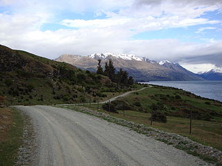
The Around the Mountains Cycle Trail is a cycle trail set in the remote wilderness of southern New Zealand. 186 km in length, it can be ridden in either direction, starting at Kingston or Walter Peak and taking three to five days at a relaxed pace to complete. The Around the Mountains Cycle Trail is recognised as one of New Zealand's 23 Great Rides.
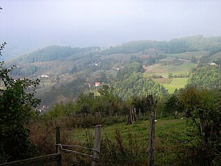
Godečevo is a village in the municipality of Kosjerić in western Serbia. The village is 100 km southwest of Belgrade. Godečevo is 837 meters above sea level, and has 599 inhabitants. According to the 2002 census, the village has a population of 599 people. There are 104 people per square kilometer around Godečevo.
Daniell Peninsula is the large peninsula between Cape Daniell and Cape Jones on the coast of Victoria Land, Antarctica. It is an elongated basalt dome similar to Adare Peninsula and Hallett Peninsula and rises to 2,000 metres (6,600 ft). It is partly separated from the Victory Mountains by Whitehall Glacier, which is afloat in its lower reaches, but is joined to these mountains by the higher land in the vicinity of Mount Prior. It was named by the New Zealand Geological Survey Antarctic Expedition (NZGSAE), 1957–58, after Cape Daniell, and by analogy with the Adare and Hallett peninsulas.
Mount Freeman is a prominent mountain, 2,880 metres (9,450 ft) high, surmounting the base of Walker Ridge, 2 nautical miles northwest of Mount Lepanto, in the Victory Mountains of Victoria Land, Antarctica.
The Holland Range is a rugged coastal mountain range in the Ross Dependency, Antarctica, on the west coast of the Ross Ice Shelf. It is about 60 nautical miles (110 km) long.
The Hope River is a river in the southern part of the West Coast region of New Zealand, being the southernmost of three rivers named Hope in the South Island. It flows west for 15 kilometres, reaching the Tasman Sea 25 kilometres north of Big Bay.

Collado de la Vera is a municipality in the province of Cáceres and autonomous community of Extremadura, Spain. The municipality covers an area of 44.94 square kilometres (17.35 sq mi) and as of 2011 had a population of 188 people. Now it has a population of about 190 people

Pipiriki is a settlement in New Zealand, on the east bank of the Whanganui River, due west of the town of Raetihi and 79 kilometres (49 mi) upriver from Whanganui; it was originally on the opposite bank. It is the location of the Paraweka Marae of the hapū Ngāti Kurawhatia of the iwi Te Āti Haunui-a-Pāpārangi.
