Related Research Articles

The Shotover River is located in the Otago region of the South Island of New Zealand. The name correctly suggests that this 75-kilometre (47 mi) long river is fast flowing, with numerous rapids. The river flows generally south from the Southern Alps on its journey running through the Skippers Canyon, draining the area between the Richardson Mountains and the Harris Mountains, before flowing into the Kawarau River east of Queenstown.
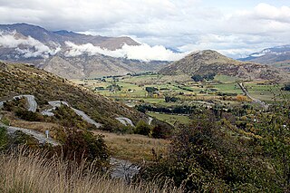
The Crown Range is a mountain range that lies to the east of the Wakatipu Basin in Otago, New Zealand. It is noted for two features, the Cardrona Alpine Resort, on the slopes of the 1900 metre Mount Cardrona, and a highway, known as the Crown Range Road, which winds steeply between Arrow Junction, just south of Arrowtown, and Wānaka to the north.

St Bathans, formerly named Dunstan Creek, is a former gold and coal mining town in Central Otago, New Zealand. The settlement was a centre of the Otago Gold Rush, but mining has since long ceased. It is now largely a holiday retreat due to the preservation of many of its historic buildings.
The Southland Plains is a general name given to several areas of low-lying land in the South Island of New Zealand, separated by the rise of the Hokonui Hills in the north. It forms a sizeable area of Southland region and encompasses its two principal settlements the city of Invercargill and the town of Gore. The Southland Plains include some of New Zealand's most fertile farmland.

The Hollyford Track is a tramping track in New Zealand. Located at the northern edge of Fiordland, in the southwestern South Island, it is unusual among Fiordland's major tracks in that it is largely flat and accessible year-round. It follows the Hollyford River which in turn follows the course of the Hollyford Valley.

Moturoa / Rabbit Island is a small island that lies across the southernmost part of Tasman Bay / Te Tai-o-Aorere, on the northern coast of New Zealand's South Island. The long narrow island runs east–west for 8 kilometres (5 mi), and covers 15 km2 (5.8 sq mi).
Lake Gunn is a lake in the South Island of New Zealand, located at 44°53′S168°05′E.

Mabel Bush is a small community in the Southland region of New Zealand's South Island. The community has an estimated population of 127 people. The main building in the area is the Mabel Bush Hall, which consists of the hall and tennis courts. The Hall is mainly used for parties and community events.
The Hapuka River is a river of Westland District, New Zealand. It flows from near The Woolsack north-west to join the Okuru and Turnbull Rivers just before they enter the Tasman Sea. The river is slow-moving and drains swampy land. There are brown trout in the lagoon area.
The Jackson River is a river of the southwestern South Island of New Zealand. It flows predominantly northeast, flowing into the Arawhata River close to the latter's outflow into Jackson Bay.
The Martyr River is a river of the West Coast Region of New Zealand's South Island. It flows generally northwest from its sources in the Olivine Range, joining its stream with the braided paths of the Cascade River 10 kilometres from the coast. New Zealand's Alpine Fault, the boundary between the Australian and Pacific tectonic plates, is exposed in the banks of the Martyr River.

The Rees River is a headwater tributary of the Clutha River / Mata-Au that drains eastward of the main divide of the Southern Alps / Kā Tiritiri o te Moana in New Zealand. The river runs 41 km, drains an area of 406 km2, and discharges into the head of Lake Wakatipu at Glenorchy. Bound by the Richardson (Whakaari) Mountains to the east and the Forbes Mountains to the west, its snow-covered headwaters rise above 2000 m.
The Smoothwater River is a river of the West Coast Region of New Zealand's South Island. It flows north to reach the Tasman Sea three kilometres west of the western end of Jackson Bay.
The Stafford River is a river of the West Coast Region of New Zealand's South Island. It flows north, reaching the Tasman Sea 10 kilometres west of the western end of Jackson Bay.
The Waihopai River — the more southerly of two New Zealand rivers of that name — runs through the South Island's Southland Region. A narrow stream for much of its 40-kilometre (25 mi) length, it has its source in several streams arising in low hill country between Edendale and Dacre, all of which run generally west-southwest, passing through or close to the township of Woodlands. These streams gradually merge, becoming one river some 15 kilometres (9 mi) east of Invercargill. The Waihopai runs west from this point, passing through the northern suburbs of Invercargill City and then turns south, running between Invercargill's built-up area and Invercargill Airport, before flowing into the northern end of the New River Estuary at Stead Street Bridge.

The Ashburton River / Hakatere is a river in the Canterbury region of New Zealand, flowing across Mid Canterbury from the Southern Alps to the Pacific Ocean. The official name of the river was amended to become a dual name by the Ngāi Tahu Claims Settlement Act 1998. It has been identified as an Important Bird Area by BirdLife International because it supports breeding colonies of the endangered black-billed gull.
Gummies Bush is a farming locality in Southland, New Zealand, 10 kilometres (6.2 mi) west of the Aparima River, 9 kilometres (5.6 mi) north of Riverton, and 18 kilometres (11 mi) south from Otautau. It is said to be named after whaler and later pig-farmer James Leader, nicknamed "Gummie" because he had no teeth. Leader had a camp in the bush in this location. To Māori, the area was known as Opuaki. It was apparently named after a person, Puaki, a word which means "to come forth in position," or "to come forth in language – that is to utter.
Terrys Creek, an urban watercourse that is part of the Lane Cove River catchment, is located in Northern Suburbs region of Sydney, Australia. It was named after Edward Terry who served as the first mayor of Eastwood municipality.

The Greenstone and Caples Tracks form a tramping (hiking) 61 kilometres (38 mi) circuit which is located in the South Island of New Zealand. Each track can be completed by itself and are linked by the McKellar Saddle while the loop also links to several other tracks including the New Zealand Great Walk of the Routeburn Track as well as the Mavora Lakes Conservation Park tracks. All of these areas are part of the Te Wāhipounamu/South-West New Zealand World Heritage Area. In 2023, the Department of Conservation (DOC) and Ngāi Tahu released 18 takahē in the Greenstone Valley.
Mataura Island is a farming community in Southland, New Zealand. It is located close to the east bank of the lower reaches of the Mataura River. Despite its name, it is no longer an island. Mataura Island is located some 40 kilometres (25 mi) east of the region's main city of Invercargill, and 15 kilometres (9.3 mi) south of the town of Edendale, on the Awarua Plains and close to the western edge of The Catlins.
References
- Land Information New Zealand place names database
44°5′50″S168°20′11″E / 44.09722°S 168.33639°E