
The Waimakariri River is one of the largest rivers in Canterbury, on the eastern coast of New Zealand's South Island. It flows for 151 kilometres (94 mi) in a generally southeastward direction from the Southern Alps across the Canterbury Plains to the Pacific Ocean.

The Taramakau River is a river of the West Coast Region of the South Island of New Zealand. It rises in the Southern Alps / Kā Tiritiri o te Moana near Harper Pass, 80 kilometres (50 mi) due east of Hokitika, and runs westward for 75 kilometres (47 mi) into the Tasman Sea 15 kilometres (9.3 mi) south of Greymouth.
Lynnford is a lightly populated locality in the Mid-Canterbury region of New Zealand's South Island. It is situated between Hinds and Eiffelton on the banks of the Hinds River, which reaches the Pacific Ocean not far to the southeast, between the nearby localities of Longbeach and Lowcliffe. Other localities close to Lynnford are Willowby and Windermere to the north.

The Hokitika River is in the West Coast of the South Island of New Zealand. It is about 64 kilometers (40 mi) long, beginning in the Southern Alps, emerging from the narrow Hokitika Gorge after merging with the Whitcombe River, and flowing into the Tasman Sea just south of the town of Hokitika. The river then feeds into the offshore Hokitika Canyon, which merges with the Cook Canyon to form the Cook Channel. The canyons extend to about 650 km (400 mi) and are important spawning areas for hoki, hake and orange roughy.
Wheatstone is a locality in the Canterbury region of New Zealand's South Island. It is located on the Canterbury Plains south of Ashburton, on the banks of the Ashburton River / Hakatere. Other nearby settlements include Huntingdon to the north, Eiffelton and Flemington to the west, Ashton and Waterton to the south, and Riverside and Wakanui to the east on the opposite side of the Ashburton River / Hakatere. Wheatstone is slightly inland from the coastline of the Pacific Ocean.

The Cropp River is a river of New Zealand. It flows east for 10 kilometres (6 mi) before joining the Whitcombe River, a tributary of the Hokitika River.

The Harman River is a river of New Zealand. It starts in the Browning Range of the Southern Alps and becomes the Arahura River, which flows into the Tasman Sea north of Hokitika.
The Kaniere River is a river of New Zealand. It is located in the West Coast Region of the South Island. The river is the outflow of Lake Kaniere, and flows west to reach the Hokitika River five kilometres from the coast of the Tasman Sea.

The Kokatahi River is a river of the West Coast Region of New Zealand's South Island. A major tributary of the Hokitika River, it flows northwest from its origins on the northern slopes of Mount Ambrose, reaching the Hokitika River 12 kilometres from the latter's mouth at Hokitika. The two rivers between them share one of the West Coast's larger floodplains.

The Mungo River is a river of the West Coast Region of New Zealand's South Island. The major source of the Hokitika River, it flows generally west from the Southern Alps, becoming the Hokitika River at the point where it turns north as it flows through a gap in the Diedrichs Range. The Hokitika Saddle separates the headwaters of the Mungo from those of the Rakaia River system which flows to the island's east coast.
The Smyth River is a river of the West Coast Region of New Zealand's South Island. It is an upper tributary of the Wanganui River, which it meets to the west of Mount Whitcombe.
The Te Rahotaiepa River is a river of the West Coast Region of New Zealand's South Island. It rises to the north of Lake Ianthe and flows parallel with the Tasman Sea coast along the edge of marshy ground for several kilometres to flow into the mouth of the Waitaha River.

The Toaroha River is a river of the West Coast Region of New Zealand's South Island. It flows generally north through a valley between the Toaroha and Diedrichs Ranges to reach the Kokatahi River 25 kilometres southeast of Hokitika.

The Tuke River is a river of the West Coast Region of New Zealand's South Island. It flows northwest from the Southern Alps, combining with the Dickson River to form the Mikonui River 15 kilometres southeast of Ross.
The Whakaikai River is a short river of the West Coast Region of New Zealand's South Island. It flows generally northwest to reach the Tasman Sea five kilometres to the northwest of the mouth of the Wanganui River.

The Wilkinson River is a short river of the West Coast Region of New Zealand's South Island. It is a tributary of the Whitcombe River.
The Taipo River is a river of the central West Coast Region of New Zealand's South Island. It flows north from its sources west of Mount Rolleston, fed by the waters of several mountain streams. After some 15 kilometres it turns northeast to flow past the Bald Range before reaching the valley of the Taramakau River into which it flows 35 kilometres east of Hokitika.

Wallsend is a locality in the West Coast region of New Zealand, located on the south side of the Grey River. It is located opposite Taylorville. The two settlements were connected via a suspension bridge for pedestrians that was known as the Taylorville bridge.

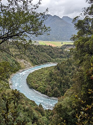
Hokitika Gorge and the surrounding Hokitika Gorge Scenic Reserve are a major tourist destination some 33 kilometres (21 mi) or 40 minutes drive inland from Hokitika, New Zealand. Since August 2020, a second suspension bridge over the Hokitika River at the gorge provides the opportunity for a round track.
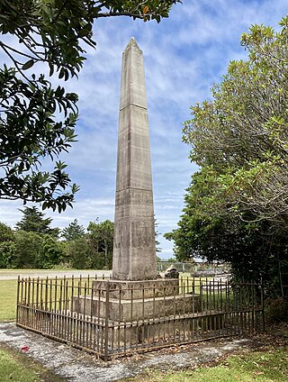
The Westland Explorers' Monument, also known as the Explorers' Monument, is an obelisk in Hokitika, New Zealand. It commemorates four men who lost their lives on the West Coast of the South Island between 1863 and 1866. The impetus for its erection in 1868 was the 1866 murder of George Dobson, and early on the monument was referred to as the Dobson Memorial. It was then referred to as the Weld Street Monument in reference to its original location in the centre of the intersection of Weld and Sewell streets. Deemed a traffic impediment, it was shifted to Hokitika Cemetery in 1880, but an even larger structure, the Hokitika Clock Tower, was put in its place at this intersection in 1902/1903.
