
The South Island, also officially named Te Waipounamu, is the larger of the two major islands of New Zealand in surface area, the other being the smaller but more populous North Island. It is bordered to the north by Cook Strait, to the west by the Tasman Sea, and to the south and east by the Pacific Ocean. The South Island covers 150,437 square kilometres (58,084 sq mi), making it the world's 12th-largest island, constituting 56% of New Zealand's land area. At low altitudes, it has an oceanic climate.

The Clutha River is the second longest river in New Zealand and the longest in the South Island. It flows south-southeast 338 kilometres (210 mi) through Central and South Otago from Lake Wānaka in the Southern Alps to the Pacific Ocean, 75 kilometres (47 mi) south west of Dunedin. It is the highest volume river in New Zealand, and the swiftest, with a catchment of 21,000 square kilometres (8,100 sq mi), discharging a mean flow of 614 cubic metres per second (21,700 cu ft/s). The river is known for its scenery, gold-rush history, and swift turquoise waters. A river conservation group, the Clutha Mata-Au River Parkway Group, is working to establish a regional river parkway, with a trail, along the entire river corridor.

The Blue River is a small river in the South Island of New Zealand. It flows its entire length within the Mount Aspiring National Park, and although on the southeastern side of the main divide, the river is within the boundaries of the West Coast region for its entire length.
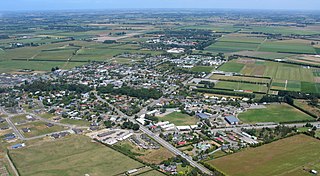
Lincoln is a town in the Selwyn District, in the Canterbury Region of New Zealand's South Island. The town is located on the Canterbury Plains to the west of Banks Peninsula, 22 kilometres southwest of Christchurch. The town has a population of 10,250, making it the second largest town in the Selwyn District behind nearby Rolleston.

The Main South Line, sometimes referred to as part of the South Island Main Trunk Railway, is a railway line that runs north and south from Lyttelton in New Zealand through Christchurch and along the east coast of the South Island to Invercargill via Dunedin. It is one of the most important railway lines in New Zealand and was one of the first to be built, with construction commencing in the 1860s. At Christchurch, it connects with the Main North Line to Picton, the other part of the South Island Main Trunk.

The Oxford Branch was a branch line railway that formed part of New Zealand's national rail network. It was located in the Canterbury region of the South Island, and ran roughly parallel with the Eyreton Branch that was located some ten kilometres south. It opened to Oxford in 1875 and survived until 1959.
The Southbridge Branch was a branch line railway that formed part of New Zealand's national rail network. It was located in the Canterbury region of the South Island and operated from 1875 until 1967. Five kilometres of the line remains open as the Hornby Branch, formerly the Hornby Industrial Line.

The Little River Branch was a branch line railway that formed part of New Zealand's national rail network. It diverged from the Southbridge Branch in Lincoln and ran down Banks Peninsula in the Canterbury region of the South Island. It was opened to Little River in 1886 and operated until 1962.

The Whitecliffs Branch was an 18.4 kilometres (11.4 mi) long branch line railway that formed part of New Zealand's national rail network in the Canterbury region of the South Island. It was more industrial than the many rural branches on the South Island's east coast whose traffic primarily derived from agriculture, and it operated from 1875 until 1962.

The Blackball Branch was a branch line railway of New Zealand's national rail network on the West Coast of the South Island and worked from the 1900s to 1966. It included the Roa Branch, also known as the Roa Incline. Roa was sometimes known as Paparoa.

The North Fork of the East Branch of the Pemigewasset River is a 6.9-mile-long (11.1 km) river located in the White Mountains of New Hampshire in the United States. It is a tributary of the East Branch of the Pemigewasset River, part of the Merrimack River watershed.

The Hurunui River is the fourth largest of the four principal rivers in north Canterbury, New Zealand, with a catchment area of 2,670 square kilometres (1,030 sq mi). The river flows from the eastern side of the Southern Alps, to the Pacific Ocean.
Mount Guyot is a mountain located in Grafton County, New Hampshire. The mountain is named after Professor Arnold H. Guyot (1807–1884) of Princeton University, and is part of the Twin Range of the White Mountains. Mount Guyot is flanked to the northwest by South Twin Mountain, to the northeast by Mount Zealand, and to the south by Mount Bond. Guyot is on the northern boundary of the Pemigewasset Wilderness. The immediate area around the summit consists of high-altitude spruce-fir forest or krummholz.

The Seddonville Branch, later truncated as the Ngākawau Branch, is a branch line railway in the West Coast region of New Zealand's South Island. Construction began in 1874 and it reached its terminus at the Mokihinui Mine just beyond Seddonville in 1895. In 1981 it was closed past Ngākawau and effectively became an extension of the Stillwater–Westport Line, since formalised as the Stillwater–Ngākawau Line.
The Conns Creek Branch was a 2.7 kilometre branch line railway in the West Coast region of New Zealand's South Island. It diverged from the Seddonville Branch at Waimangaroa and followed the southern bank of the Waimangaroa River to the line's terminus at Conns Creek at the foot of the Denniston Incline. The line operated from 1877 until 1967 and existed for the sole purpose of conveying coal from mines to the port of Westport.

The Pere Marquette River is a river in Michigan in the United States. The main stream of this river is 63.9 miles (102.8 km) long, running from Lake County south of Baldwin into the Pere Marquette Lake, and from there into Lake Michigan.
The Allen River is a river in the West Coast district of the South Island of New Zealand. It drains the south side of the Allen Range, elevations to 1,450 metres (4,760 ft), which forms part of the boundary between West Coast and Tasman districts. The river has left and right branches for half its length, and the right branch has a major tributary stream in a valley between the two branches. The united river flows south through a narrow gorge and is joined by the Johnson River 200 metres (660 ft) upstream of its confluence with the North branch of the Mōkihinui River.

The Ashburton River / Hakatere is a river in the Canterbury region of New Zealand, flowing across Mid Canterbury from the Southern Alps to the Pacific Ocean. The official name of the river was amended to become a dual name by the Ngāi Tahu Claims Settlement Act 1998. It has been identified as an Important Bird Area by BirdLife International because it supports breeding colonies of the endangered black-billed gull.
The Hurunui River South Branch is a river in the Hurunui District of Canterbury, New Zealand.


