Mount Graham (New Zealand)

Last updated

Mount Graham
Lake Kaniere, West Coast, New Zealand 11.jpg
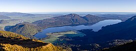
Lake Kaniere with Mt Graham in the middle
Highest point
Elevation 829 m (2,720 ft)
Coordinates 42°50′12″S171°06′15″E / 42.83664°S 171.10415°E / -42.83664; 171.10415
Naming
Defining authority New Zealand Geographic Board
Geography
New Zealand (relief map).png
Red triangle with thick white border.svg
Mount Graham
CountryNew Zealand
Region West Coast
Territorial authority Westland District
Topo map Land Information New Zealand  NZ Topo50, BV19

Mount Graham is a mountain in the West Coast Region of New Zealand with an elevation of 829 metres above sea level. [1] Lake Kaniere is immediately east of Mount Graham. It is also a prime spot for hunting Red deer during the breeding season. [2] The mountain is covered in dense bush which makes it hard to reach the summit.

Related Research Articles

<span class="mw-page-title-main">Aoraki / Mount Cook</span> Mountain in New Zealand

Aoraki / Mount Cook is the highest mountain in New Zealand. Its height, as of 2014, is listed as 3,724 metres. It sits in the Southern Alps, the mountain range that runs the length of the South Island. A popular tourist destination, it is also a favourite challenge for mountain climbers. Aoraki / Mount Cook consists of three summits: from south to north, the Low Peak, the Middle Peak and the High Peak. The summits lie slightly south and east of the main divide of the Southern Alps, with the Tasman Glacier to the east and the Hooker Glacier to the southwest. Mount Cook is ranked 10th in the world by topographic isolation.

<span class="mw-page-title-main">Chamois</span> Species of antelope

The chamois or Alpine chamois is a species of goat-antelope native to the mountains in Southern Europe, from the Pyrenees, the Alps, the Apennines, the Dinarides, the Tatra to the Carpathian Mountains, the Balkan Mountains, the Rila–Rhodope massif, Pindus, the northeastern mountains of Turkey, and the Caucasus. It has also been introduced to the South Island of New Zealand. Some subspecies of chamois are strictly protected in the EU under the European Habitats Directive.

<span class="mw-page-title-main">Aoraki / Mount Cook National Park</span> National park in New Zealand

Aoraki / Mount Cook National Park is a national park located in the central-west of the South Island of New Zealand. It was established in October 1953 and takes its name from the highest mountain in New Zealand, Aoraki / Mount Cook. The area of the park is 707 km2 (273 sq mi), and it shares a border with Westland Tai Poutini National Park along the Main Divide of the Southern Alps. The national park consists of reserves that were established as early as 1885 to protect the area's significant landscape and vegetation. Glaciers cover 40% of the park, including the county's largest glacier, Haupapa / Tasman Glacier. In 1990, the park was included in the area designated as the Te Wāhipounamu World Heritage Site. The park is managed by the Department of Conservation (DOC) alongside Ngāi Tahu, the iwi who are mana whenua in the region.

<span class="mw-page-title-main">Mount Aspiring / Tititea</span> Mountain in New Zealand

Mount Aspiring / Tititea is New Zealand's 23rd-highest mountain. The peak's altitude of 3,033 metres (9,951 ft) makes it the country's highest outside the Aoraki / Mount Cook region.

<span class="mw-page-title-main">Mount Cook Village</span> Town in New Zealand

Mount Cook Village, officially Aoraki / Mount Cook, is located within New Zealand's Aoraki / Mount Cook National Park at the end of State Highway 80, only 15 kilometres (9.3 mi) south of the summit of the country's highest mountain, also called Aoraki / Mount Cook, in the Southern Alps.

The Dennistoun Glacier is a glacier, 50 nautical miles long, draining the northern slopes of Mount Black Prince, Mount Royalist and Mount Adam in the Admiralty Mountains of Victoria Land, Antarctica. It flows northwest between the Lyttelton Range and Dunedin Range, turning east on rounding the latter range to enter the sea south of Cape Scott.

<span class="mw-page-title-main">Mount Hikurangi (Gisborne District)</span> Mountain in New Zealand

Mount Hikurangi is a 1,752 m (5,748 ft) peak in the eastern corner of New Zealand's North Island, about 80 kilometres (50 mi) north of Gisborne, and 50 kilometres (31 mi) southwest of the East Cape Lighthouse. On a spur of the Raukumara Range in the Waiapu Valley, it is the North Island's highest non-volcanic peak.

Blue Mountains are a range of rugged hills in West Otago, in southern New Zealand. They form a barrier between the valleys of the Clutha and Pomahaka Rivers. They lie between the towns of Tapanui and Lawrence and rise to 1019 metres (3280 ft).

<span class="mw-page-title-main">Lendenfeld Peak</span> Mountain in New Zealand

Lendenfeld Peak, in the past also Mount Lendenfeld, is the eighth highest named summit in New Zealand and in Aoraki / Mount Cook National Park.

<span class="mw-page-title-main">Braeburn Range</span> Mountains in New Zealand

The Braeburn Range is a mountain range in the Tasman Region of New Zealand's South Island. It lies to the west of Lake Rotoroa and much of the eastern flank of the range is within the Nelson Lakes National Park. The range runs south-southeast, with a westwards curve at the northern end and several westward-trending spurs.

<span class="mw-page-title-main">Pirongia Forest Park</span>

Pirongia Forest Park is a protected area 30 km southwest of Hamilton, New Zealand. It covers 167.7 square kilometres (64.7 sq mi) across four blocks of land - Pirongia, Te Maunga O Karioi Block, and the small Mangakino Block and Te Rauamoa Block. The park encompasses Mount Pirongia west of Pirongia and Mount Karioi near the coast southwest of Raglan. Wairēinga / Bridal Veil Falls Scenic Reserve is located nearby, but is separate to Pirongia Forest Park.

<span class="mw-page-title-main">Mount Sefton</span> Mountain in New Zealand

Mount Sefton is a mountain in the Aroarokaehe Range of the Southern Alps of New Zealand, just 12 kilometres (7.5 mi) south of Aoraki / Mount Cook. To the south lies Mount Brunner, and to the north The Footstool, both more than 400 metres (1,300 ft) shorter.

<span class="mw-page-title-main">Norman Hardie</span> New Zealand climber (1924–2017)

Norman David Hardie was a New Zealand climber who was one of the climbers on the 1955 British Kangchenjunga expedition who first reached the summit of the 8,586-metre (28,169 ft) mountain, the third-highest mountain in the world.

<span class="mw-page-title-main">La Perouse (New Zealand)</span> Mountain in South Island, New Zealand

La Perouse, originally called Mount Stokes, is a mountain in New Zealand's Southern Alps, rising to a height of 3,078 metres (10,098 ft).

Mount Whitcombe is a mountain in New Zealand's Southern Alps, rising to a height of 2,650 metres (8,690 ft).

<span class="mw-page-title-main">Murchison Mountains</span> Mountains in Fiordland National Park in New Zealand

The Murchison Mountains are a group of mountains in Fiordland National Park in New Zealand. It is the location where the South Island takahē, a type of bird presumed extinct, was rediscovered in 1948. The highest mountain is Mount Lyall at 1,892 metres (6,207 ft).

<span class="mw-page-title-main">Mount Haast (Westland District)</span> Mountain in Westland District, New Zealand

Mount Haast is a mountain summit located in the Southern Alps / Kā Tiritiri o te Moana, in the Westland District of New Zealand. The mountain was named after the German-born geologist Julius von Haast by James Mackay (1831–1912).

Mount Harper / Mahaanui is a mountain in Canterbury, New Zealand, within the foothills of the Southern Alps / Kā Tiritiri o te Moana. The mountain is the tallest point of the Harper Range, which is separated from the nearby Ben Macleod and Tara Haoa ranges to the south by the Rangitata River, and from the Moorhouse Range to the east by the Pudding valley. A number of small lakes lie to the north of Mahaanui, most notably including Lake Clearwater.

<span class="mw-page-title-main">Mount Haidinger</span> Mountain in New Zealand

Mount Haidinger is a mountain of the Southern Alps, located in Aoraki / Mount Cook National Park. It has a double peak, with the northern peak being nine meters lower than the southern peak.

References

  1. LINZ's 1:50,000 map at the interactive topographic map of New Zealand site
  2. "Kokatahi-Toaroha hunting". www.doc.govt.nz. Retrieved 28 June 2023.