
Taumatawhakatangihangakoauauotamateaturipukakapikimaungahoronukupokaiwhenuakitanatahu is a hill near Pōrangahau, south of Waipukurau in southern Hawke's Bay, New Zealand. The height of the hill is 305 metres (1,001 ft). The hill is notable primarily for its unusually long name, which is of Māori origin; it is often shortened to Taumata for brevity. It has gained a measure of fame as it is the longest place name found in any English-speaking country, and possibly the longest place name in the world, according to World Atlas. The name of the hill has also been listed in the Guinness World Records as the longest place name. Other versions of the name, including longer ones, are also sometimes used.

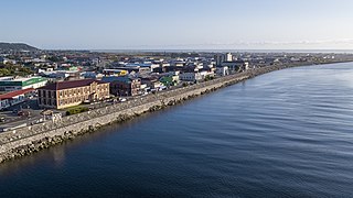
Whanganui, also spelt Wanganui, is a city in the Manawatū-Whanganui region of New Zealand. The city is located on the west coast of the North Island at the mouth of the Whanganui River, New Zealand's longest navigable waterway. Whanganui is the 19th most-populous urban area in New Zealand and the second-most-populous in Manawatū-Whanganui, with a population of 42,800 as of June 2023.
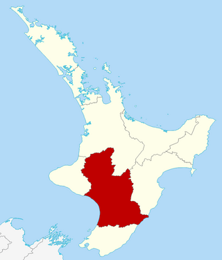
Manawatū-Whanganui is a region in the lower half of the North Island of New Zealand, whose main population centres are the cities of Palmerston North and Whanganui. It is administered by the Manawatū-Whanganui Regional Council, which operates under the name Horizons Regional Council.

Think Big was an interventionist state economic strategy of the Third National Government of New Zealand, promoted by the Prime Minister Robert Muldoon (1975–1984) and his National government in the early 1980s. The Think Big schemes saw the government borrow heavily overseas, running up a large external deficit, and using the funds for large-scale industrial projects. Petrochemical and energy related projects figured prominently, designed to utilise New Zealand's abundant natural gas to produce ammonia, urea fertiliser, methanol and petrol.
Greymouth is the largest town in the West Coast region in the South Island of New Zealand, and the seat of the Grey District Council. The population of the whole Grey District is 14,250, which accounts for 43% of the West Coast's inhabitants. The Greymouth urban area had an estimated population of 8,340. A large proportion of the District, 65%, is part of the Conservation Estate owned and managed by the Department of Conservation making Greymouth a natural centre for walkers and trampers.
Big River or Big Rivers may refer to:
Awarua Point is located on the southwestern coast of New Zealand's South Island, at the northern end of Big Bay, 40 kilometres (25 mi) north of Milford Sound / Piopiotahi, and 15 kilometres (9.3 mi) north of the mouth of the Hollyford River / Whakatipu Kā Tuka.

The Whanganui River is a major river in the North Island of New Zealand. It is the country's third-longest river, and has special status owing to its importance to the region's Māori people. In March 2017 it became the world's second natural resource to be given its own legal identity, with the rights, duties and liabilities of a legal person. The Whanganui Treaty settlement brought the longest-running litigation in New Zealand history to an end.
The Cascade River is a river of the South Island of New Zealand. It flows north for 30 kilometres (19 mi) from its source in Mount Aspiring National Park in the Southern Alps, forming a deep valley between the Olivine Range and Red Hills Range. From the end of this valley it turns west to cross a low-lying swampy floodplain before entering the Tasman Sea close to Cascade Point, a headland halfway between Big Bay and Jackson Bay.
The Eastern Hohonu River is a river of New Zealand. It rises in the Hohonu Range, an outlying range of the Southern Alps 28 kilometres southeast of Greymouth, flowing north then east before reaching its outflow into Lake Brunner. It is named the Eastern Hohonu River to differentiate it from the nearby Big Hohonu River, which is also called the Greenstone River.
The Jerry River is a river of the southwestern South Island of New Zealand. It flows northwest into the Gorge River, which flows into the Tasman Sea between Jackson Bay and Big Bay.
The Big River is a river in the Grey District, in the West Coast region of New Zealand's South Island. It is a tributary of the Grey River.

The Paddle Steamer Waimarie is a historic riverboat based on the Whanganui River in New Zealand. She is the only coal–fired paddle steamer still operating in New Zealand. Waimarie was built in 1899 by Yarrow & Co. in London and transported to New Zealand in kitset form to be assembled at Whanganui. She operated on the Whanganui River for 49 years before being laid up. In 1952 she sank at her moorings and lay in the mud for the next 40 years.
Big Bay, also known as Awarua Bay, is a deep indentation in the southwestern coast of New Zealand's South Island, 40 kilometres north of Milford Sound and immediately to the north of Martins Bay. The bay is eight kilometres in width, and extends eight kilometres into the South Island, making an almost square indentation in the island's coastline. Its northern end is Awarua Point. Immediately beyond Long Reef, the rocky point at the southern end, is the mouth of the Hollyford River and Martins Bay. Big Bay has a sandy beach named Three Mile Beach. The Awarua River enters the bay at the northern end of the beach.
The Hope River is a river in the southern part of the West Coast region of New Zealand, being the southernmost of three rivers named Hope in the South Island. It flows west for 15 kilometres, reaching the Tasman Sea 25 kilometres north of Big Bay.
The Greenstone River / Hokonui, also known as the Big Hohonu River, is a river on the West Coast of New Zealand's South Island. It rises in the Hohonu Range, an outlying range of the Southern Alps / Kā Tiritiri o te Moana, roughly 30 kilometres (19 mi) southeast of Greymouth. The river flows northwest for its entire length, eventually joining the same river valley as the larger Taramakau River near the town of Kumara. From here, the two rivers flow roughly parallel for around 5 kilometres (3.1 mi) before the Greenstone / Hokonui joins the Taramakau just shy of the latter's mouth in the Tasman Sea. The area surrounding the river was historically home to gold mining operations, following the discovery of payable amounts of gold in 1864. The township of Greenstone was established on the river in the wake of this discovery, with other industries including a sawmill soon being established.

The Big Muddy Creek is an estuarine tidal inlet of the Auckland Region of New Zealand's North Island. It flows south from its tributary rivers, the Nihotupu Stream and the Island stream in the Waitākere Ranges which are dammed at the Lower Nihotupu Reservoir, towards the Manukau Harbour.


