
Sir Johann Franz Julius von Haast was a German-born New Zealand explorer, geologist, and founder of the Canterbury Museum in Christchurch.

Haast is a small town in the Westland District on the West Coast of New Zealand's South Island. The township is beside the Haast River, 3 kilometres (2 mi) south of Haast Junction, on State Highway 6. The Haast region is in Te Wahipounamu – The South West New Zealand World Heritage, a UNESCO World Heritage Site designated in 1990.

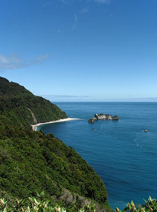
Jackson Bay / Okahu is a gently curving 24-kilometre (15 mi) bay on the southern West Coast of the South Island of New Zealand. It faces the Tasman Sea to the north, and is backed by the Southern Alps. It contains the settlements of Hannahs Clearing, Waiatoto, Neils Beach, and the fishing village of Jackson Bay at its western end. The bay is the southernmost terminus of the West Coast's roads.

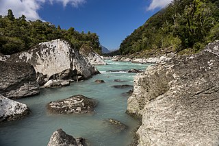
The Haast River / Awarua is a river on the West Coast of the South Island of New Zealand. The Māori name for the river is Awarua. It drains the western watershed of the Haast Pass. The Haast River is 100 kilometres (62 mi) in length, and enters the Tasman Sea near Haast township. The river's main tributary is the Landsborough River.
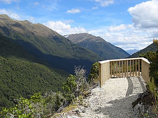
Haast Pass / Tioripatea is a mountain pass in the Southern Alps of the South Island of New Zealand. Māori used the pass in pre-European times.

Lake Hāwea is New Zealand's ninth largest lake located on the South Island in the Otago Region at an altitude of 348 m. It covers 141 km2 and is 392 m deep.
The Turnbull River is a short river on the West Coast of New Zealand's South Island. It flows northwest from the Southern Alps for 22 kilometres (14 mi), entering the Tasman Sea at the northern end of Jackson Bay, 10 kilometres (6.2 mi) south of Haast. The Turnbull shares its mouth with the Okuru River.
Knights Point is on the West Coast of New Zealand's South Island.
Haast is a German family name. It may refer to:
The Burke River is a river of New Zealand's South Island, located in Mount Aspiring National Park. It flows east for 19 kilometres (12 mi) from close to the Mueller Pass, reaching the Haast River 10 kilometres (6 mi) south of the Haast Pass.
The Maori River is a river of the West Coast Region of New Zealand's South Island. It flows from several sources in the Mataketake Range east of Haast, passing through the small Tawharekiri Lakes before becoming a tributary of the Waita River, which flows into the Tasman Sea 15 kilometres north of Haast.

The Moeraki River is a river of the West Coast Region of New Zealand's South Island. It flows west from the Southern Alps, veering northwest as it approaches the coast. It flows into the eastern end of the small Lake Moeraki before flowing out the western end to reach the Tasman Sea 20 kilometres northeast of Haast.
The Ngatau River is a river of the West Coast region of New Zealand's South Island. It flows north-west from its sources in the Southern Alps to meet the Okuru River 20 kilometres (12 mi) south-east of Haast. The river's entire length is within Mount Aspiring National Park.
The Waiatoto River is a river of the West Coast of New Zealand's South Island. Formed from several small rivers which are fed by glaciers surrounding Mount Aspiring / Tititea, it flows north along a valley flanked in the west by the Haast Range before turning northwest to reach the Tasman Sea 20 kilometres (12 mi) southwest of Haast. Much of the river's length is within Mount Aspiring National Park.
The Greymouth Star, formerly the Greymouth Evening Star, is a daily newspaper published in Greymouth and circulated on the West Coast of New Zealand's South Island from Westport to Haast.

Tauparikākā Marine Reserve is a marine reserve located offshore about 20 kilometres (12 mi) north of Haast on the West Coast of New Zealand's South Island. It covers the area immediately offshore from Ship Creek, which is also known as Tauparikākā in Māori.
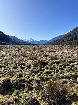
Pleasant Flat is an alluvial floodplain of the Haast River in the Haast Pass on New Zealand's South Island. A former stopping place for travellers crossing the pass before the building of the highway, it now has a campsite and picnic shelter. It has a notable view of Mount Hooker to the northeast.

Roaring Billy Falls is a waterfall in Mount Aspiring National Park, Westland District, New Zealand. It is located in the Haast River valley, around 30 km (19 mi) inland from Haast, near Eighteen Mile Bluff on State Highway 6. The falls are a 30-metre-high (98 ft) cascade on The Roaring Billy stream. The bottom of the cascade is at an elevation of around 80 metres (262 ft) where it flows into the Haast River.

Thunder Creek Falls is a waterfall in Mount Aspiring National Park, Westland District, New Zealand. It is located in the Haast River valley, around 52 kilometres (32 mi) inland from Haast, near the Gates of Haast bridge on State Highway 6. The falls are about 28 metres (92 ft) high and the base is at an elevation of around 120 metres (390 ft) where it flows into the Haast River.

Ship Creek is a small river that flows into an area of coastal swamp forest on the West Coast of New Zealand's South Island. Ship Creek is approximately 11 km (6.8 mi) long and flows northwest from catchment areas on the slopes of Bald Hill, reaching the Tasman Sea around 20 km (12 mi) north-east of Haast. Near the mouth of Ship Creek, there are short walks around dune lakes and ancient kahikatea swamp forest.


