
The Tadorninae is the shelduck-sheldgoose subfamily of the Anatidae, the biological family that includes the ducks and most duck-like waterfowl such as the geese and swans.

The mallard or wild duck is a dabbling duck that breeds throughout the temperate and subtropical Americas, Eurasia, and North Africa. It has been introduced to New Zealand, Australia, Peru, Brazil, Uruguay, Argentina, Chile, Colombia, the Falkland Islands, and South Africa. Belonging to the subfamily Anatinae of the waterfowl family Anatidae, mallards live in wetlands, eat water plants and small animals, and are social animals preferring to congregate in groups or flocks of varying sizes.

Aythya is a genus of diving ducks, with twelve species currently accepted. The genus was described in 1822 by the German zoologist Friedrich Boie, with the type species being greater scaup. The name Aythya comes from the Ancient Greek word αἴθυιᾰ, which referred to an unknown diving-bird.

The blue duck or whio is a member of the duck, goose and swan family Anatidae endemic to New Zealand. It is the only member of the genus Hymenolaimus. Its exact taxonomic status is still unresolved, but it appears to be most closely related to the tribe Anatini, the dabbling ducks.

The Whanganui National Park is a national park located in the North Island of New Zealand. Established in 1986, it covers an area of 742 km2 bordering the Whanganui River. It incorporates areas of Crown land, former state forest and a number of former reserves. The river itself is not part of the park, but is a popular paddling route titled the Whanganui Journey, one of New Zealand's "Great Walks". The New Zealand Department of Conservation highlights Whanganui National Park as being the National Park most closely tied to human settlement.

The brown teal is a species of dabbling duck of the genus Anas native to New Zealand. For many years it had been considered to be conspecific with the flightless Auckland and Campbell teals in Anas aucklandica; the name "brown teal" has also been largely applied to that entire taxon. Common in the early years of European colonisation, the "brown duck" was heavily harvested as a food source. Its numbers quickly fell, especially in the South Island, and in 1921 they became fully protected. Captive breeding and releasing into predator-controlled areas has seen good localised populations re-introduced around the country in recent years.

The Australasian shoveler is a species of dabbling duck in the genus Spatula. It ranges from 46 to 53 cm. It lives in heavily vegetated swamps. In Australia it is protected under the National Parks and Wildlife Act 1974. They occur in southwestern and southeastern Australia, Tasmania, and New Zealand. The male has a blue-grey head with a vertical white crescent in front of the eyes.
Salvadori's teal or Salvadori's duck, is a species of bird endemic to New Guinea. It is placed in the monotypic genus Salvadorina.

The Sedgwick County Zoo is an AZA-accredited wildlife park and major attraction in Wichita, Kansas, United States. Founded in 1971, with the help of the Sedgwick County Zoological Society, the zoo has quickly become recognized both nationally and internationally for its support of conservation programs and successful breeding of rare and endangered species. Having over 3,000 animals of nearly 400 species, the zoo has slowly increased its visitors and now ranks as the number one outdoor tourist attraction in the state.

The blue-billed duck is a small Australian stiff-tailed duck, with both the male and female growing to a length of 40 cm (16 in). The male has a slate-blue bill which changes to bright-blue during the breeding season, hence the duck's common name. The male has deep chestnut plumage during breeding season, reverting to a dark grey. The female retains black plumage with brown tips all year round. The duck is endemic to Australia's temperate regions, inhabiting natural inland wetlands and also artificial wetlands, such as sewage ponds, in large numbers. It can be difficult to observe due to its cryptic nature during its breeding season through autumn and winter. The male duck exhibits a complex mating ritual. The blue-billed duck is omnivorous, with a preference for small aquatic invertebrates. BirdLife International has classified this species as Least concern. Major threats include drainage of deep permanent wetlands, or their degradation as a result of introduced fish, peripheral cattle grazing, salinization, and lowering of ground water.

The Pere Marquette River is a river in Michigan in the United States. The main stream of this river is 63.9 miles (102.8 km) long, running from Lake County south of Baldwin into the Pere Marquette Lake, and from there into Lake Michigan.
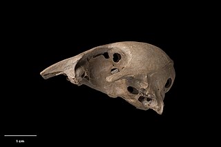
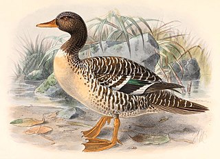
The New Zealand stiff-tailed duck is an extinct duck species from New Zealand which is known only from subfossil remains. It was first described as a distinct species by Trevor H. Worthy in 2005.
The blue duck is a species of duck, endemic to New Zealand.
Teal is a blue-green color .
The Cobungra River, a perennial river of the North-East Murray catchment of the Murray-Darling basin, is located in the East Gippsland and Alpine regions of Victoria, Australia.
Anglers Rest is a locality in Victoria, Australia. It is on the Omeo Highway, 28.5 kilometres (17.7 mi) north of Omeo in the Shire of East Gippsland, almost totally surrounded by the Alpine National Park.

Little Wanganui is a dairy-farming village on the West Coast of the South Island of New Zealand, on the Little Wanganui River. It is 77 kilometres (48 mi) north of Westport and 21 kilometres (13 mi) south of Karamea, at the opposite end of the Karamea Beach. The settlement has a pub, community hall, and volunteer fire brigade, and in 2013 the population was 207. There is a surfing beach, and the Little Wanganui River is popular for whitebaiting and fishing for brown trout.

Victoria Forest Park, is situated on the West Coast of the South Island of New Zealand. At 2,069 square kilometres (799 sq mi) it is New Zealand's largest forest park. The park is administered by the Department of Conservation (DOC).
Manuherikia is a genus of extinct species of ducks from the Miocene of New Zealand. It was described from fossil material of the Saint Bathans Fauna, in the lower Bannockburn Formation of the Manuherikia Group, found by the Manuherikia River in the Central Otago region of the South Island. The genus name comes from the name of the geological formation in which the fossils were found and, ultimately, from the Manuherikia River and its valley.
Matanas enrighti is an extinct duck from the Miocene of New Zealand. It was described from fossil material collected from a Saint Bathans Fauna site near Mata Creek, in the lower Bannockburn Formation of the Manuherikia Group, in the Manuherikia River valley in the Central Otago region of the South Island.


