
Alexandra is a town in the Central Otago district of the South Island of New Zealand. It is on the banks of the Clutha River, on State Highway 8, 188 kilometres (117 mi) by road from Dunedin and 33 kilometres (21 mi) south of Cromwell. The nearest towns to Alexandra via state highway 8 are Clyde seven kilometers to the northwest and Roxburgh forty kilometers to the south. State highway 85 also connects Alexandra to Omakau, Lauder, Oturehua, Ranfurly and on to Palmerston on the East Otago coast.

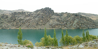
The Clutha River, officially Clutha / Mata-Au, is the second longest river in New Zealand and the longest in the South Island. It flows south-southeast 338 kilometres (210 mi) through Central and South Otago from Lake Wānaka in the Southern Alps / Kā Tiritiri o te Moana to the Pacific Ocean, 75 kilometres (47 mi) south west of Dunedin. It is the highest volume river in New Zealand, and the swiftest, with a catchment of 21,960 square kilometres (8,480 sq mi), discharging a mean flow of 614 cubic metres per second (21,700 cu ft/s). The Clutha River is known for its scenery, gold-rush history, and swift turquoise waters. A river conservation group, the Clutha Mata-Au River Parkway Group, is working to establish a regional river parkway, with a trail, along the entire river corridor.

The Clyde Dam, New Zealand's third largest hydroelectric dam, is built on the Clutha River near the town of Clyde. It is owned and operated by Contact Energy.

Think Big was an interventionist state economic strategy of the Third National Government of New Zealand, promoted by the Prime Minister Robert Muldoon (1975–1984) and his National government in the early 1980s. The Think Big schemes saw the government borrow heavily overseas, running up a large external deficit, and using the funds for large-scale industrial projects. Petrochemical and energy related projects figured prominently, designed to utilize New Zealand's abundant natural gas to produce ammonia, urea fertilizer, methanol and petrol.

Cromwell is a town in Central Otago in the Otago region of New Zealand.
Central Otago is located in the inland part of the Otago region in the South Island of New Zealand. The motto for the area is "A World of Difference".

The Kawarau River is a river in the South Island of New Zealand. It drains Lake Wakatipu in northwestern Otago via the lake's Frankton Arm. The river flows generally eastwards for about 60 kilometres (37 mi) and passes through the steep Kawarau Gorge until it joins Lake Dunstan near Cromwell. Before the construction of the Clyde High Dam, the Kawerau joined the Clutha River in a spectacular confluence at Cromwell. The Shotover River enters the Kawerau from the north; the Nevis River enters it from the south. With many rapids and strong currents, the river can be dangerous and has claimed many lives: it is also popular for bungy jumping and kayaking.
The Cromwell Gorge is a deep gorge on the Clutha River in the Otago region of New Zealand's South Island. It stretches for 20 km south of the town of Cromwell towards Alexandra. It is one of three substantial river gorges in Central Otago, the others being the Kawarau Gorge to the west of Cromwell, and the Roxburgh Gorge downstream from Alexandra.

Clyde, formerly Dunstan, is a small town in Central Otago, New Zealand with a population of 1023 in 2018. It is located on the Clutha River, between Cromwell and Alexandra.

The Roxburgh Dam is the earliest of the large hydroelectric projects in the lower half of the South Island of New Zealand. It lies across the Clutha River / Mata-Au, some 160 kilometres (99 mi) from Dunedin, some 9 kilometres (5.6 mi) to the north of the town of Roxburgh. The settlement of Lake Roxburgh Village is close to the western edge of the dam.

Lake Hāwea is New Zealand's ninth largest lake.
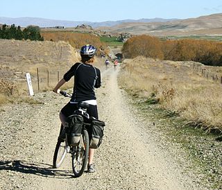
The Otago Central Rail Trail is a 150-kilometre walking, cycling and horse riding track in the South Island of New Zealand. A pioneering project for New Zealand, the successful rail trail joined the New Zealand Cycle Trail umbrella organisation in 2012, having been one of the inspirations for it.

Wedderburn is a community in Central Otago, New Zealand. It is located 15 kilometres northwest of Ranfurly, and was at one time close to the centre of a thriving gold and coal mining area. The name of Wedderburn was given to the area by John Turnbull Thomson, and is one of the names in his infamous "Thomson's Barnyard", wedder being Northumbrian dialect form of the word wether, meaning a castrated sheep.

The Otago Central Railway (OCR) or in later years Otago Central Branch Railway, now often referred to as the Taieri Gorge Railway, was a secondary railway line in Central Otago, in the South Island of New Zealand.

The Cromwell chafer beetle is a flightless beetle in the family Scarabaeidae. It is found in just one spot in Central Otago, New Zealand, which is now a beetle reserve.

State Highway 8 is one of New Zealand's eight national highways. It forms an anticlockwise loop through the southern scenic regions of the Mackenzie Basin and Central Otago, starting and terminating in junctions with State Highway 1. Distances are measured from north to south.
Lowburn is a small settlement in Central Otago, in the South Island of New Zealand. It is located close to the shores of the man-made Lake Dunstan, which was formed by the building of the Clyde Dam. Lowburn lies between the towns of Wanaka and Cromwell.
The Clutha Mata-Au River Parkway Group, New Zealand, was formed in October 2003, and is an Incorporated Society, with Charitable and Donee Status. The Group was set up in response to land development issues along the Clutha Mata-Au River corridor, much of which has high scenic and recreational values. The project aims to establish a regional river parkway, including a river trail, along the entire 338 km river corridor from Lake Wānaka to the Pacific Ocean.
The Save Aramoana Campaign was formed in 1974 to oppose a proposed aluminium smelter at Aramoana in New Zealand.

The Southern Lakes is an unofficial name given to an area of the southern South Island of New Zealand. Despite being an unofficial designation, the term Southern Lakes is sometimes used by organisations such as the New Zealand Meteorological Service and Automobile Association. Though exact definitions vary, the area encompasses parts of western Southland and Central Otago, and is occasionally extended to include the Mackenzie Basin of inland Canterbury, a total of roughly 28,000 to 35,000 square kilometres.


