West Otago is the local name given to part of the region of Otago, New Zealand, lying close to the border with Southland. It is administratively connected to South Otago, but is geographically separated from it by a range of hills known as the Blue Mountains. The largest settlements in West Otago are Tapanui and Heriot, and other localities within the area include Moa Flat, Edievale, Merino Downs, and Waikoikoi. The area described as West Otago is sometimes extended to include Lawrence and Beaumont. The ghost town of Kelso also lies within West Otago. Other notable features of the area include Conical Hill and Landslip Hill, the latter being a major fossil-bearing formation.

The Manuherikia River is located in Otago in the South Island of New Zealand. It rises in the far north of the Maniototo, with the West Branch draining the eastern side of the St Bathans Range, and the East Branch draining the western flanks of the Hawkdun Range. The river continues southwest through the wide Manuherikia Valley to its confluence with the Clutha River at Alexandra. During the 1860s the Manuherikia was one of the centres of the Central Otago Gold Rush.
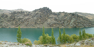
The Cromwell Gorge is a deep gorge on the Clutha River in the Otago region of New Zealand's South Island. It stretches for 20 km south of the town of Cromwell towards Alexandra. It is one of two substantial river gorges in Central Otago, the other being the Kawarau Gorge, located to the west of Cromwell.

Gabriel's Gully is a locality in Otago, New Zealand, three kilometres from Lawrence township and close to the Tuapeka River.
The Nevis River is in Otago, New Zealand. It flows north for 40 kilometres (25 mi) through rough country before meeting the Kawarau River, of which it is a tributary. A prominent rock outcrop close to this junction is known as the Nevis Bluff.
Roxburgh is a small New Zealand town of about 600 people in Central Otago. It is in Teviot Valley on the banks of the Clutha River, 40 kilometres (25 mi) south of Alexandra in the South Island. State Highway 8, which links Central Otago with Dunedin city, passes through the town. Roxburgh is well known for its Roxdale fruit and "Jimmy's Pies."
Beaumont is a small town in inland Otago, in the South Island of New Zealand. It is located on the Clutha River six kilometres southeast of Raes Junction, between Roxburgh and Balclutha. Beaumont is connected to Milton and Roxburgh by State Highway 8.
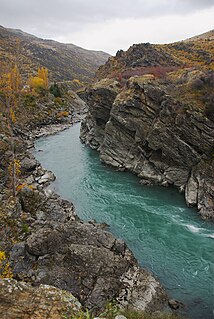
The Kawarau Gorge is a major river gorge, located in Central Otago, in the South Island of New Zealand. The Kawarau River flows through the gorge, which is located between the towns of Queenstown and Cromwell, and part of the route of State Highway 6 also follows the gorge.

The Beaumont River is a river in the Central Otago district of New Zealand. It is a tributary of the Clutha River, merging with it just upstream of the small town of Beaumont.
The Camelot River is a river of Fiordland National Park, New Zealand. It is formed from the confluence of the Elaine Stream and Cozette Burn and flows west into the Gaer Arm of Bradshaw Sound. The estuary is protected by the Kutu Parera Marine Reserve.
The Cust River is a river in the Canterbury Region of New Zealand. It flows east across the upper Canterbury Plains from its source north of the town of Oxford, New Zealand, flowing into the Cam River / Ruataniwha close to the town of Rangiora. The small town of Cust lies on the banks of the river. The lower part of the river, to the south-west of Rangiora, is diverted into a channel and called the "Main Drain". The channel was built in 1862 to drain the swampy land between Rangiora and the Waimakariri River, and when it was enlarged in 1868 it accidentally captured the Cust.
The Little Pomahaka River is a river of New Zealand, a tributary of the Pomahaka River which it joins east of the Whitecoomb Range.
The Whitestone River is a river in New Zealand, a tributary of the Mararoa River. It has been identified as an Important Bird Area by BirdLife International because it supports breeding colonies of the endangered black-billed gull.
The Earnscleugh or Fraser River is a river of the Otago Region of New Zealand. It arises in the Old Man Range and flows north-east to the Fraser Dam, then south-east to the Clutha River about 4 km west of Alexandra. The name Earnscleugh is given to the upper reaches of the river. The lower reaches are called the Fraser River, after one of the owners of Earnscleugh Station, William Fraser, who introduced rabbits to the area.
Ophir is a small settlement in Central Otago, New Zealand, located between Alexandra and Ranfurly close to the east bank of the Manuherikia River. The settlement of Omakau is located on the opposite bank, 3 kilometres (1.9 mi) to the northwest.

Duranbah is a town located in north-eastern New South Wales, Australia, in the Tweed Shire.
Becks is a small settlement in the Otago Region of the South Island of New Zealand. It is located on State Highway 85, some 16 kilometres (9.9 mi) north-east of Omakau, and just west of where the State Highway crosses the Manuherikia River. It lies on the 45th parallel south.

Teviot Brook is a waterway in South East Queensland, Australia. It rises in the Main Range at Carneys Creek and joins the Logan River at Cedar Grove. It is part of the Clarence Moreton Basin, a sedimentary basin on the easternmost part of the Australian continent.


