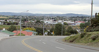
Balclutha is a town in South Otago, lying towards the end of the Clutha River, on the east coast of the South Island of New Zealand. It is about halfway between Dunedin and Gore on the Main South Line railway, State Highway 1 and the Southern Scenic Route. Balclutha has a population of 4,340, and is the largest town in South Otago.

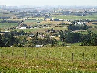
Middlemarch is a small town in the Otago region of New Zealand's South Island. It lies at the foot of the Rock and Pillar Range of hills in the broad Strath-Taieri valley, through which flows the middle reaches of the Taieri River. Since local government reorganisation in the late 1980s, Middlemarch and much of the Strath-Taieri has been administered as part of Dunedin city, the centre of which lies some 80 km to the southeast. Middlemarch is part of the Taieri electorate, and is currently represented in parliament by Ingrid Leary. Middlemarch has reticulated sewerage but no reticulated water supply. A description of 1903, that "[T]he summer seasons are warm, but not enervating, and the winters cold, but dry" is still true today.

Oban is the principal settlement on Stewart Island / Rakiura, the southernmost inhabited island of the New Zealand archipelago. Oban is located on Halfmoon Bay, on Paterson Inlet. It has aircraft connections with Invercargill and a ferry service to Bluff.

Kurow is a small town in the Waitaki District, New Zealand. It is located on the south bank of the Waitaki River, 60 kilometres (37 mi) northwest of Oamaru.

Naseby is a small town, formerly a borough, in the Maniototo area of Central Otago, New Zealand. It is named after a village in Northamptonshire, England. Previous names of the township were Parker's, Hogburn and Mt Ida. The town catch phrase is "2000 feet above worry level" indicating its altitude. Naseby is 395 km from Christchurch and 143 km from Dunedin.

Tapanui is a small town in West Otago in New Zealand's South Island, close to the boundary with Southland region.

Clyde, formerly Dunstan, is a small town in Central Otago, New Zealand with a population of 1,260 in June 2023. It is located on the Clutha River, between Cromwell and Alexandra.

Glenorchy is a small settlement at the northern end of Lake Wakatipu in the South Island region of Otago, New Zealand. It is approximately 45 km (28 mi) by road or boat from Queenstown, the nearest large town. There are two pubs, a café and a range of small shops in the town catering mainly to tourists but also to the small resident population. There is also a small airstrip which caters to small planes.

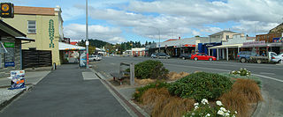
Ranfurly is a town in the Central Otago District of Otago, New Zealand. Located 110 kilometres north of Dunedin, it lies in the dry rough plain of Maniototo at a moderately high altitude close to a small tributary of the Taieri River. It operates as a service town for the local farming community. The town was formerly known as Eweburn, one of the "farmyard" names bestowed by former Otago Chief Surveyor John Turnbull Thomson on many small streams and locations in the district. The modern name honours the Fifth Earl of Ranfurly, who served as Governor of New Zealand (1897–1904) at the time of the extension of the Otago Central Railway to the area. Ranfurly is well known for its Art Deco buildings, such as its hotel and the milk bar.

Lake Roxburgh is an artificial lake, created by the Roxburgh Dam, the earliest of the large hydroelectric projects in the southern South Island of New Zealand. It lies on the Clutha River, some 160 km (99 mi) from Dunedin. It covers an area of some 6 km2 (2.3 sq mi), and extends for nearly 30 km (19 mi) towards the town of Alexandra. The town of Roxburgh lies 5 kilometres (3.1 mi) south of the Dam.
Roxburgh is a small New Zealand town of about 600 people in Central Otago. It is in Teviot Valley on the banks of the Clutha River, 40 kilometres (25 mi) south of Alexandra in the South Island. State Highway 8, which links Central Otago with Dunedin city, passes through the town. Roxburgh is well known for its Summer fruit and "Jimmy's Pies."
The small town of Herbert, formerly Otepopo, lies in North Otago, New Zealand, 91 kilometres (57 mi) north of Dunedin and 22 kilometres (14 mi) south-west of Oamaru. It lies on the edge of the Herbert Forest.

Lumsden is a town in Southland, New Zealand. Lying in a gap in the surrounding hills, Lumsden is the location of a major junction on State Highway 6. Lumsden is 81 kilometres north of Invercargill, 106 kilometres south of Queenstown, 59 kilometres west of Gore and 77 kilometres east of Te Anau.

Taieri Mouth is a small fishing village at the mouth of the Taieri River, New Zealand. Taieri Island (Moturata) lies in the ocean several hundred metres off the river's mouth.

Millers Flat is a small town in inland Otago, in the South Island of New Zealand. It is located on the Clutha River, 17 kilometres south of Roxburgh. Fruit growing is the main industry in the area. Most of the town lies on the north bank of the Clutha; the main road, State Highway 8, passes close by on the river's other bank. The Roxburgh Branch railway used to pass through the town; it was opened to Millers Flat in 1925 and was the terminus for approximately two and a half years, until the section to Roxburgh was opened. The line was closed in 1968, though the town's station platform and some of the railway formation still exist.

Owaka is a small town in the Clutha District of South Otago, in the South Island of New Zealand. It is the largest community in the rugged, forested Catlins area, close to the border with Southland, some 35 km (22 mi) south of Balclutha on the Southern Scenic Route.
Orari is a small town in the South Canterbury region of New Zealand's South Island, roughly midway between Ashburton to the north, and Timaru to the south it is the northernmost town of South Canterbury.

Wairau Valley is the valley of the Wairau River in Marlborough, New Zealand and also the name of the main settlement in the upper valley. State Highway 63 runs through the valley. The valley opens onto the Wairau Plain, where Renwick and Blenheim are sited. The Alpine–Wairau Fault runs along the length of the valley.
Waitarere Beach is a small settlement in the Horowhenua District of the Manawatū-Whanganui region of New Zealand's North Island. It is located on the South Taranaki Bight, 14 kilometres northwest of Levin, and 17 kilometres southwest of Foxton, both distances being by road.
Harwood is a rural settlement on the northern side of the Otago Peninsula. It is within the boundaries of Dunedin city in New Zealand.

