
Cairns is a city in the Cairns Region, Queensland, Australia. It is on the east coast of Far North Queensland. The city is the 5th-most-populous in Queensland and ranks 14th overall in Australia.

Raes Junction is a small settlement in New Zealand, located at the intersection of State Highways 8 and 90, in the lower South Island. The highways which meet at the junction are the main routes to the Clutha valley for travellers from Dunedin and Invercargill respectively.

Balmain, New South Wales is a suburb in the Inner West of Sydney, New South Wales, Australia. Balmain is located 6 km west of the Sydney central business district, in the local government area of the Inner West Council. It sits on a small peninsula that juts out of Sydney Harbour, directly opposite Milsons Point.
Albion is an inner north-eastern suburb of the City of Brisbane, the state capital of Queensland, Australia.

Fortitude Valley is a suburb of central Brisbane, the state capital of Queensland, Australia. The suburb lies immediately northeast of the Brisbane central business district, and is one of the hubs of Brisbane's nightlife, renowned for its nightclubs, bars and adult entertainment. At the 2016 Australian Census Fortitude Valley recorded a population of 6,978. In the 1950s, the suburb was the largest shopping precinct outside a central business district in Australia.

Rooty Hill is a suburb of Sydney, in the state of New South Wales, Australia. Rooty Hill is located 42 kilometres west of the Sydney central business district, in the local government area of the City of Blacktown and is part of the Greater Western Sydney region.

Muswellbrook is a town in the Upper Hunter Region of New South Wales, Australia, about 243 km (151 mi) north of Sydney and 127 km (79 mi) north-west of Newcastle.

The Sydney central business district is the main commercial centre of Sydney, the state capital of New South Wales and the most populous city in Australia. It extends southwards for about 3 km (2 mi) from Sydney Cove, the point of first European settlement in which the Sydney region was initially established. Due to its pivotal role in Australia's early history, it is one of the oldest established areas in the country.

Alexandria is an inner-city suburb of Sydney, New South Wales, Australia. Alexandria is located 4 kilometres south of the Sydney central business district and is part of the local government area of the City of Sydney. The postcode is 2015.

Berrima is a historic village in the Southern Highlands of New South Wales, Australia, in Wingecarribee Shire. The village, once a major town, is located on the Old Hume Highway between Canberra and Sydney. It was previously known officially as the Town of Berrima. It is close to the three major towns of the Southern Highlands; Mittagong, Bowral and Moss Vale.

Mount Victoria is a small township in the Blue Mountains of New South Wales, Australia. It is the westernmost village in the City of Blue Mountains, located about 120 kilometres (75 mi) by road from the Sydney central business district and at an altitude of about 1,052 metres (3,451 ft) AHD . The settlement had a population of 823 people at the 2011 Census.

St Marys is a suburb in western Sydney, in the state of New South Wales, Australia. It is 45 kilometres west of the Sydney central business district, in the local government area of the City of Penrith.

Millers Flat is a small town in inland Otago, in the South Island of New Zealand. It is located on the Clutha River, 17 kilometres south of Roxburgh. Fruit growing is the main industry in the area. Most of the town lies on the north bank of the Clutha; the main road, State Highway 8, passes close by on the river's other bank. The Roxburgh Branch railway used to pass through the town; it was opened to Millers Flat in 1925 and was the terminus for approximately two and a half years, until the section to Roxburgh was opened. The line was closed in 1968, though the town's station platform and some of the railway formation still exist.

The Balclutha Road Bridge, which spans the Clutha River in Balclutha, South Otago, New Zealand, is one of the best-known road bridges in New Zealand's South Island. The bridge is often simply known as "The Clutha Bridge", despite the fact that there are numerous bridges across the country's second longest river.
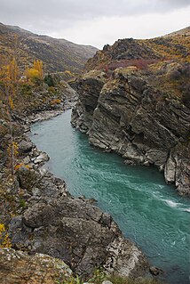
The Kawarau Gorge is a major river gorge, located in Central Otago, in the South Island of New Zealand. The Kawarau River flows through the gorge, which is located between the towns of Queenstown and Cromwell, and part of the route of State Highway 6 also follows the gorge.

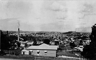
Ipswich is the innermost suburb of Ipswich, Queensland, Australia. The suburb situated on the Bremer River.

Sussex Street is a street in the central business district of Sydney in New South Wales, Australia. It runs north-south along the western side of the city, between Hickson Road and Hay Street. It is in the local government area of the City of Sydney. The street is 1.7 kilometres (1.1 mi) long. It was named in honour of Prince Augustus Frederick, Duke of Sussex, the sixth son of King George III.

Toowoomba City is the central suburb of Toowoomba, Queensland, Australia, containing its central business district.
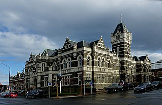
The Dunedin Law Courts is a notable historic building in central Dunedin in the South Island of New Zealand. They are located at the corner of Lower Stuart Street and Anzac Square, directly opposite the city's historic railway station.


