Otago is a region of New Zealand located in the southern half of the South Island administered by the Otago Regional Council. It has an area of approximately 32,000 square kilometres (12,000 sq mi), making it the country's second largest local government region. Its population was 246,000 in June 2022.

Alexandra is a town in the Central Otago district of the South Island of New Zealand. It is on the banks of the Clutha River, on State Highway 8, 188 kilometres (117 mi) by road from Dunedin and 33 kilometres (21 mi) south of Cromwell. The nearest towns to Alexandra via state highway 8 are Clyde seven kilometers to the northwest and Roxburgh forty kilometers to the south. State highway 85 also connects Alexandra to Omakau, Lauder, Oturehua, Ranfurly and on to Palmerston on the East Otago coast.

Arrowtown is a historic gold mining town in the Otago region of the South Island of New Zealand. Arrowtown is located on the banks of the Arrow River approximately 7.5 km from State Highway 6. Arrowtown is located 19.5 kilometres to the east of Queenstown. As well as the route via State Highway 6 at Arrow Junction, there is also road access directly to Queenstown via Arthurs Point and a third route via the picturesque Lake Hayes.
Naseby is a small town, formerly a borough, in the Maniototo area of Central Otago, New Zealand. It is named after a village in Northamptonshire, England. Previous names of the township were Parker's, Hogburn and Mt Ida. The town catch phrase is "2000 feet above worry level" indicating its altitude. Naseby is 395 km from Christchurch and 143 km from Dunedin.
Central Otago is an area located in the inland part of the Otago region in the South Island of New Zealand. The motto for the area is "A World of Difference".

The Manuherikia River is located in Otago in the South Island of New Zealand. It rises in the far north of the Maniototo, with the West Branch draining the eastern side of the St Bathans Range, and the East Branch draining the western flanks of the Hawkdun Range. The river continues southwest through the wide Manuherikia Valley to its confluence with the Clutha River at Alexandra. During the 1860s the Manuherikia was one of the centres of the Central Otago Gold Rush.

The Maniototo Plain, usually simply known as The Maniototo, is an elevated inland region in Otago, New Zealand. The region roughly surrounds the upper reaches of the Taieri River and the Manuherikia River. It is bounded by the Kakanui Range to the north and the Rock and Pillar Range to the southeast. It has a harsh, dry climate, ranging from over 30 °C in mid-summer to -15 °C in mid-winter.

The Otago Gold Rush was a gold rush that occurred during the 1860s in Central Otago, New Zealand. This was the country's biggest gold strike, and led to a rapid influx of foreign miners to the area – many of them veterans of other hunts for the precious metal in California and Victoria, Australia.

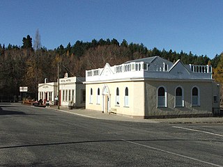
St Bathans, formerly named Dunstan Creek, is a former gold and coal mining town in Central Otago, New Zealand. The settlement was a centre of the Otago Gold Rush, but mining has since long ceased. It is now largely a holiday retreat due to the preservation of many of its historic buildings.

Ranfurly is a town in the Central Otago District of Otago, New Zealand. Located 110 kilometres north of Dunedin, it lies in the dry rough plain of Maniototo at a moderately high altitude close to a small tributary of the Taieri River. It operates as a service town for the local farming community. The town was formerly known as Eweburn, one of the "farmyard" names bestowed by former Otago Chief Surveyor John Turnbull Thomson on many small streams and locations in the district. The modern name honours the Fifth Earl of Ranfurly, who served as Governor of New Zealand (1897–1904) at the time of the extension of the Otago Central Railway to the area. Ranfurly is well known for its Art Deco buildings, such as its hotel and the milk bar.

Omakau is a settlement in Central Otago, New Zealand, located between Alexandra and Ranfurly on the northwest bank of the Manuherikia River. The smaller settlement of Ophir, New Zealand is located on the opposite bank, three kilometres to the southeast.

Hyde is a locality in Otago, New Zealand, located in the Strath-Taieri. It is close to the northern end of the Rock and Pillar Range on State Highway 87 between Middlemarch and Ranfurly. Hyde is best known as the site of the Hyde railway disaster of 4 June 1943, in which 21 people were killed when an express train on the Otago Central Railway derailed at high speed in a cutting near the town. At the time, it was the worst railway accident in New Zealand's history; it has only been passed by the Tangiwai disaster of 24 December 1953, which claimed the lives of 151 people. The site of the Hyde disaster can now be walked as part of the Otago Central Rail Trail and a monument, a 2.5 m high cairn, stands as a memorial to the victims.
The township of Oturehua is in the Ida Valley of the Maniototo, in Central Otago, in the South Island of New Zealand.
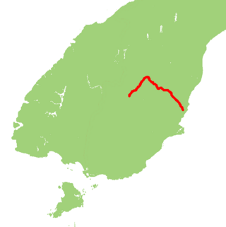
State Highway 85 (SH 85) is a South Island state highway in New Zealand, servicing the Maniototo Plains and the North and Central Otago regions of the South Island between the major settlements of Alexandra and Palmerston. It is wholly two lane and passes through some of the most extreme climatic regions in New Zealand. The highway is known colloquially as "The Pigroot". Though there is no definitive explanation for this name, A. W. Reed, in his book Place Names of New Zealand, mentions an incident during John Turnbull Thomson's survey of inland Otago in which local wild pigs were so unafraid of humans that a huge boar approached his party and rubbed its nose against that of Thomson's horse.
The Ida Valley lies east of the Manuherikia Valley in Central Otago, New Zealand. At an altitude of around 500 m (1,600 ft), the 40 km long flat and wide valley is a relatively dry region with cold winters and hot summers, much like the rest of Central Otago. The majority of agricultural production in the Ida Valley is lamb, including merino, and also stud cattle.
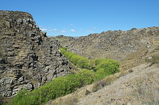
The Poolburn Gorge is a gorge located in the Central Otago region of the South Island of New Zealand, 4 km east of the small settlement of Lauder. The Ida Burn flows through the 2.5 km long canyon across the Raggedy Range between the Ida Valley and the Manuherikia Valley. There are no public roads through the gorge; only the track of the former Otago Central Railway, now used as the Otago Central Rail Trail, follows the river on the southern flanks of the gorge.

Becks is a small settlement in the Otago Region of the South Island of New Zealand. It is located on State Highway 85, some 16 kilometres (9.9 mi) north-east of Omakau, and just west of where the State Highway crosses the Manuherikia River. It lies on the 45th parallel south.

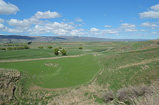
Poolburn Reservoir, also known as Poolburn Dam, is a reservoir in Central Otago, New Zealand. Built during the Great Depression for irrigation but also as an employment initiative, the water is used by farmers in the Ida Valley.
Poolburn is a small rural settlement in Central Otago, in the South Island of New Zealand. It is located in the Ida Valley nine kilometres to the southeast of Ophir. It has a primary school, a former hotel, a community hall, a sports ground, tennis courts and a (closed) church. It has nearby historic gold mine workings at the eastern foot of the Raggedy Range.


