Education
The local children are educated at Maniototo Area School in the nearby town of Ranfurly. Children catch a free school bus to the school, which caters for students aged 5–18.

Waipiata is an historic place on the Otago Central Rail Trail, in Central Otago, New Zealand. Waipiata is also the name of many New Zealand coastal vessels, steamers, freighters and steamships. [1]
Waipiata became a thriving township as the Otago Central Railway line snaked across the Maniototo Plain. A school opened in 1891. The nearby village of Kokonga was the railway camp.
In 1914 the Waipiata Sanatorium, a private facility owned by Dr George Byres was constructed, a few kilometres south of Waipiata near the old Hamiltons gold field. In the early 1920s Dr Byres' facility was taken over by the Hospital Board and continued for a long period as a sanatorium for tuberculosis patients. The sanatorium closed in 1961 and the buildings became a corrective and training centre for the Justice Department until 1979, after which the government sold the site. Today it remains a privately owned property. [2]
A factory with 78 employees processed rabbits from 1901 at Coneys Creek (Green Bridge) until a factory was built in Waipiata. This operated until a slump in prices closed it by the 1930s. The buildings were later used for a variety of purposes, e.g. as a woolshed and as a concrete works. Waipiata today has an hotel, a bowling green, tennis courts, a domain, a library, a large public hall and private and holiday homes. The iron bridge, known locally as the 'Green Bridge', was built in 1896. Timber from the original bridge was used for the side rails and decking. It is the only flood-free road crossing of the Taieri River in the Maniototo. Considerable money has been spent rebuilding both the north and south abutments. It has recently been repainted its original green colour. The Central Otago District Plan Schedule 19.4 includes the Green Bridge, the War Memorial and Hamiltons Cemetery in its register of heritage buildings, places, sites and objects. Hamiltons Cemetery has been restored and a memorial plaque put in place to record all those buried there. There is an information kiosk on site. A book released in August 2008, "Old Waipiata" by Jim Sullivan, [3] features pictures and stories up until about 1950.
Grahame Sydney, one of New Zealand's most successful landscape painters, has long been captivated by the local landforms and views. Cook House is an example, Demolition at Waipiata is another.
New Zealand domestic and International visitors cycling the Otago Central Rail Trail pass through Waipiata.
Special care is required in the summer as the temperatures can rise above 40 °C, but the days can also be cold and wet, more suited to hard-core bikers than casual cyclists. Spring is often a windy time with a cold bite in the mornings. The weather is better in late spring. Summer has very hot days, which are long, so that biking in the cooler parts of the day avoids the heat. In Autumn the weather is more settled without the temperature extremes and forest fires of the other seasons. Late autumn colours appear in mid to late April. This is the busiest time on the trail.
"The Miocene Waipiata Volcanic Field (WVF) is an eroded phreatomagmatic volcanic field. Pyroclastic rocks of most of the Waipiata vents record initial phreatomagmatic explosive activity fuelled by groundwater followed by Strombolian-style eruptions. The longest vent alignment, traceable in 30 km, coincides with and is parallel to the largest fault zone in the Otago region, the NW-SE trending Waihemo- fault zone."
Geological examination of the Lherzolite xenolith bearing flows from the east Otago province with regard to the crystal fractionation of upper mantle magmas, results; "The limited data support the contention that the asthenosphere below southern New Zealand and western Antarctica is essentially homogeneous over a scale of hundreds of kilometres." Royal Society of New Zealand bulletin 23:344-365.
Taieri Lake lies near Waipiata in the Maniototo district.
There is fishing at Rutherford's Dam, above Waipiata, on private property. This is an irrigation dam built to collect and store water during the summer. All fishing methods may be used at all sites. Fishing
The NZ Sheepbreeders Association runs the annual Rabobank New Zealand Ewe Hogget Competition. Local winners of the 'other breed' categories in 2004 were: John & Sally Andrews, Waipiata, Ranfurly. Breed - Composite. RAS
Register of Community Drinking-Water Supplies in New Zealand; » Waipiata Tavern Bore.
For Waipiata topographic info see Map 260 H42 Waipiata - LINZ
The local community produced a Community Plan in 2008 setting development priorities for the area. The community sees roading, local history and water supplies as key community issues. A regular newsletter is produced which can be viewed at the community webpage. .
The local children are educated at Maniototo Area School in the nearby town of Ranfurly. Children catch a free school bus to the school, which caters for students aged 5–18.
| Climate data for Waipiata (1951–1980) | |||||||||||||
|---|---|---|---|---|---|---|---|---|---|---|---|---|---|
| Month | Jan | Feb | Mar | Apr | May | Jun | Jul | Aug | Sep | Oct | Nov | Dec | Year |
| Mean daily maximum °C (°F) | 20.9 (69.6) | 21.0 (69.8) | 18.5 (65.3) | 14.9 (58.8) | 10.3 (50.5) | 7.0 (44.6) | 6.4 (43.5) | 9.1 (48.4) | 12.5 (54.5) | 15.0 (59.0) | 17.0 (62.6) | 19.3 (66.7) | 14.3 (57.8) |
| Daily mean °C (°F) | 14.7 (58.5) | 14.5 (58.1) | 12.7 (54.9) | 9.5 (49.1) | 5.6 (42.1) | 2.9 (37.2) | 2.2 (36.0) | 4.3 (39.7) | 7.1 (44.8) | 9.4 (48.9) | 11.2 (52.2) | 13.3 (55.9) | 9.0 (48.1) |
| Mean daily minimum °C (°F) | 8.4 (47.1) | 7.9 (46.2) | 6.9 (44.4) | 4.1 (39.4) | 0.9 (33.6) | −1.2 (29.8) | −2.0 (28.4) | −0.5 (31.1) | 1.6 (34.9) | 3.7 (38.7) | 5.3 (41.5) | 7.2 (45.0) | 3.5 (38.3) |
| Average rainfall mm (inches) | 50 (2.0) | 37 (1.5) | 48 (1.9) | 35 (1.4) | 35 (1.4) | 27 (1.1) | 23 (0.9) | 23 (0.9) | 23 (0.9) | 36 (1.4) | 44 (1.7) | 43 (1.7) | 424 (16.8) |
| Source: NIWA [4] | |||||||||||||
Otago is a region of New Zealand located in the southern half of the South Island administered by the Otago Regional Council. It has an area of approximately 32,000 square kilometres (12,000 sq mi), making it the country's second largest local government region. Its population was 257,200 in June 2024.

Alexandra is a town in the Central Otago district of the South Island of New Zealand. It is on the banks of the Clutha River, on State Highway 8, 188 kilometres (117 mi) by road from Dunedin and 33 kilometres (21 mi) south of Cromwell. The nearest towns to Alexandra via state highway 8 are Clyde seven kilometres to the northwest and Roxburgh forty kilometres to the south. State highway 85 also connects Alexandra to Omakau, Lauder, Oturehua, Ranfurly and on to Palmerston on the East Otago coast.

Middlemarch is a small town in the Otago region of New Zealand's South Island. It lies at the foot of the Rock and Pillar Range of hills in the broad Strath-Taieri valley, through which flows the middle reaches of the Taieri River. Since local government reorganisation in the late 1980s, Middlemarch and much of the Strath-Taieri has been administered as part of Dunedin city, the centre of which lies some 80 km to the southeast. Middlemarch is part of the Taieri electorate, and is currently represented in parliament by Ingrid Leary. Middlemarch has reticulated sewerage but no reticulated water supply. A description of 1903, that "[T]he summer seasons are warm, but not enervating, and the winters cold, but dry" is still true today.

Naseby is a small town, formerly a borough, in the Maniototo area of Central Otago, New Zealand. It is named after a village in Northamptonshire, England. Previous names of the township were Parker's, Hogburn and Mt Ida. The town catch phrase is "2000 feet above worry level" indicating its altitude. Naseby is 395 km from Christchurch and 143 km from Dunedin.

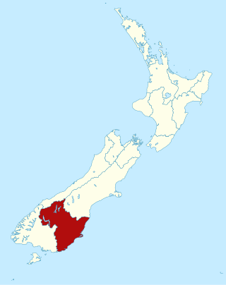
Central Otago is an area located in the inland part of the Otago region in the South Island of New Zealand. The motto for the area is "A World of Difference".

The Taieri River is the fourth-longest river in New Zealand and is in Otago in the South Island. Rising in the Lammerlaw Range, it initially flows north, then east around the Rock and Pillar range before turning southeast, reaching the sea 30 kilometres (19 mi) south of Dunedin.

The Maniototo Plain, usually simply known as The Maniototo, is an elevated inland region in Otago, New Zealand. The region roughly surrounds the upper reaches of the Taieri River and the Manuherikia River. It is bounded by the Kakanui Range to the north and the Rock and Pillar Range to the southeast. It has a harsh, dry climate, ranging from over 30 °C in mid-summer to -15 °C in mid-winter.
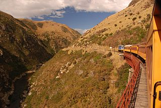
Dunedin Railways is the trading name of Dunedin Railways Limited, an operator of a railway line and tourist trains based at Dunedin Railway Station in the South Island of New Zealand. The company is a council-controlled trading organisation wholly owned by Dunedin City Council through its holding company Dunedin City Holdings Limited.

Ranfurly is a town in the Central Otago District of Otago, New Zealand. Located 110 kilometres north of Dunedin, it lies in the dry rough plain of Maniototo at a moderately high altitude close to a small tributary of the Taieri River. It operates as a service town for the local farming community. The town was formerly known as Eweburn, one of the "farmyard" names bestowed by former Otago Chief Surveyor John Turnbull Thomson on many small streams and locations in the district. The modern name honours the Fifth Earl of Ranfurly, who served as Governor of New Zealand (1897–1904) at the time of the extension of the Otago Central Railway to the area. Ranfurly is well known for its Art Deco buildings, such as its hotel and the dairy.

The Strath Taieri is a large glacial valley and river plateau in New Zealand's South Island. It is surrounded by the rugged hill ranges to the north and west of Otago Harbour. Since 1989 it has been part of the city of Dunedin. The small town of Middlemarch is located at its southern end.
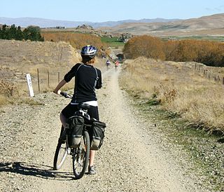
The Otago Central Rail Trail is a 150-kilometre walking, cycling and horse riding track in the South Island of New Zealand. A pioneering project for New Zealand, the successful rail trail joined the New Zealand Cycle Trail umbrella organisation in 2012, having been one of the inspirations for it.

Wedderburn is a community in Central Otago, New Zealand. It is located 15 kilometres northwest of Ranfurly, and was at one time close to the centre of a thriving gold and coal mining area. The name of Wedderburn was given to the area by John Turnbull Thomson, and is one of the names in his infamous "Thomson's Barnyard", wedder being Northumbrian dialect form of the word wether, meaning a castrated sheep.

Patearoa is a small settlement in inland Otago in New Zealand's South Island. It is located 20 kilometres southwest of Ranfurly, in the Maniototo and was originally known as Sowburn. Andrew Buchanan was an early runholder in Patearoa.

The Rock and Pillar Range, is a range of high hills is located in the Maniototo, an area of inland Otago, New Zealand. The range is surrounded on three sides by the Taieri River, which has its source in the Lammerlaw Range. The river flows out across the scroll plain at Paerau, along the north west flanks of the Rock and Pillar Range before almost doubling back on itself at Waipiata and flowing back along the eastern side past Hyde through the Strath-Taieri. The town of Middlemarch lies close to the Taieri River to the east of the range, and Patearoa lies to the northwest.

The Otago Central Railway (OCR) or in later years Otago Central Branch Railway, now often referred to as the Taieri Gorge Railway, was a secondary railway line in Central Otago, in the South Island of New Zealand.

Hyde is a locality in Otago, New Zealand, located in the Strath-Taieri. It is close to the northern end of the Rock and Pillar Range on State Highway 87 between Middlemarch and Ranfurly. Hyde is best known as the site of the Hyde railway disaster of 4 June 1943, in which 21 people were killed when an express train on the Otago Central Railway derailed at high speed in a cutting near the town. At the time, it was the worst railway accident in New Zealand's history; it has only been passed by the Tangiwai disaster of 24 December 1953, which claimed the lives of 151 people. The site of the Hyde disaster can now be walked as part of the Otago Central Rail Trail and a monument, a 2.5 m high cairn, stands as a memorial to the victims.
The Dunback and Makareao Branches were two connected branch line railways, part of New Zealand's national rail network. Located in the Otago region of the South Island, both lines were 15 kilometres (9.3 mi) in length and shared the first 11 kilometres (6.8 mi). The Dunback Branch, also known as the Waihemo Branch, opened in 1885 and closed in 1968; the Makareao Branch, also known as the Inch Valley Railway or the Inch Valley Branch, opened in 1900 and operated for 89 years to 1989.

Maniototo Area School is an area school in Ranfurly, Central Otago, New Zealand, serving students aged 5–18. Founded in 1879, it has 154 students as of August 2024. The school has a strong sporting tradition and an academic programme bolstered by video conferencing lessons and the OtagoNet project.

State Highway 87 (SH 87) is a state highway in New Zealand servicing the Taieri Plains and the Strath-Taieri Valley in Otago, connecting Mosgiel to Kyeburn on the eastern flank of the Maniototo Plains.
Kyeburn is a small settlement in Otago, in the South Island of New Zealand. It lies on the Maniototo, a wide, high plain stretching from the end of the Strath-Taieri valley.